Issue Date: Sunday, July 5th, 2020
Issue Time: 9:15AM MDT
— Flooding is NOT expected today
There is some very dry air to our west and southwest, which will start to fill in over the state as the 500mb High shifts slightly to the west throughout the day. That means the moisture tap from the south will be shut off, and storm coverage will begin to decrease across the state. Storm motion will also become more southwesterly due to the location of the High. The dry air has already started to work its way into western Colorado at the mid and upper levels of the atmosphere, and a downtick in moisture is expected throughout the day from west to east. There will be enough residual moisture for another round of scattered storms over the mountains this afternoon (favoring mountains east of the Continental Divide), but coverage and rain rates are expected to decrease for the most part. As the storms roll off the high terrains, coverage of storms over the adjacent plains is also expected to lessen. A couple storms will likely be able survive over the elevated regions of the Cheyenne Ridge and Palmer Ridge, but most other storms will produce only light rainfall and gusty outflow winds as they dissipate. Although some local, moderate rain rates are likely under the stronger storms, they should remain below flood threat criteria.
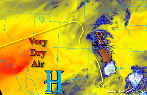
Additional scattered thunderstorms will be possible over the far southeast corner of the state as the disturbance marked in the water vapor image below (orange “X”) moves counterclockwise around the high. Storms are not anticipated to become as severe due to limited shear, but some gusty outflow winds and smaller-end hail will still be possible in the pulse-like storms. Wetting rainfall and high, localized rain totals will be possible over the area with higher dew points still intact, which is great news for the ongoing drought (Baca County was recently upgraded to the D4 category). However, with the dry soils/growing crops and small heavy rainfall cores, flooding is not expected outside of some nuisance field ponding. Therefore, no flood threat will be issued.
Today’s Flood Threat Map
For more information on today’s flood threat, see the map below. If there is a threat, hover over the threat areas for more details, and click on burn areas to learn more about them. For Zone-Specific forecasts, scroll below the threat map.

Zone-Specific Forecasts:
San Juan Mountains, Central Mountains, Northern Mountains, Southeast Mountains, & Front Range:
Best chance for wetting rainfall from storms today will be along and east of the Continental Divide (Front Range & Southeast Mountains). Weaker storms will less coverage are expected over the western high terrains as the dry air moves overhead. Max 1-hour rain rates up to 0.15 inches (west) and 0.75 inches (east) will still be possible. Most storms over the eastern mountains will produce only 0.20 to 0.40 inches. Storms will have less coverage than yesterday as well, but will be capable of producing some brief, gusty outflow winds. Confidence is much lower that a storm will form over a burn area this afternoon, and rain rates are not likely to meet flooding thresholds. None the less, follow NWS Pueblo for all burn area flash flood warnings. Flooding is not forecast.
Primetime: 1PM to 10:30PM
Southeast Plains, Northeast Plains, Palmer Ridge, Raton Ridge, & Urban Corridor:
Storms will likely dissipate as they move off the mountains except over elevated ridges (Palmer and Cheyenne). Max 1-hour rain rates up to 0.90 inches will be possible with most storms producing only 0.50 inches. With southwesterly steering flow, storms are not anticipated to make it into the eastern plains. Additional storms will be possible over the far Southeast Plains associated with a disturbance moving south around the High. Severe weather parameters are on the low-end, so the main threat will be very localized heavy rainfall and strong outflow winds. Outside of nuisance field ponding, flooding is not anticipated.
Primetime: 2PM to 10PM
Northwest Slope, San Luis Valley, Grand Valley, & Southwest Slope:
It’s going to be dry and hot today with isolated, weak storms possible over the higher terrains of Rio Blanco/Garfield Counties and the Grand Valley. Storms will likely only produce sprinkles, but isolated totals up to 0.20 inches (north) will be possible. High temperatures will flirt with the 100F mark over the western valleys with 80Fs forecast for the San Luis Valley. Flooding is not forecast.