Issue Date: Sunday, July 12th, 2020
Issue Time: 9:40AM MDT
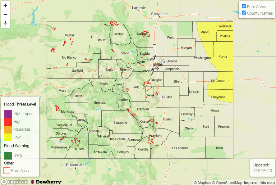
— A LOW flood threat has been issued for the Southeast Plains and eastern Raton Ridge
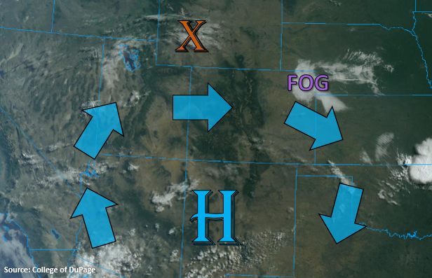
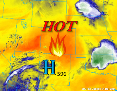
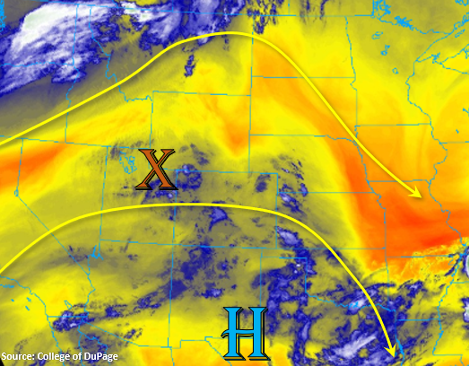
Today will be quite the pattern change from the last couple of days. Moisture has returned to the state, which can be seen by the blue plume below. This moisture is helping create some morning fog and cloud cover over eastern Colorado where dew points are in the 50Fs and 60Fs. It’s also a bit windy over the eastern plains with south winds gusting between 25 and 35 mph. PW has risen to 0.64 inches over Grand Junction, which will mean that afternoon and evening storms will return to the forecast. Mid-level energy traveling around the High, including the shortwave marked with the orange “X” below, will allow a little better coverage of scattered storms over the lower elevations as well. As the shortwave (marked below) traverses eastward, it will help spark scattered storms over the Front Range and Southeast Mountains in conjunction with the diurnal flow. Inverted-V soundings indicate that storms that form will be capable of producing brief, gusty winds in addition to some lightning. Rainfall accumulations should be low, so flooding in not expected. As storms move into the adjacent plains, a little higher accumulation is anticipated along the Palmer and Raton Ridge.
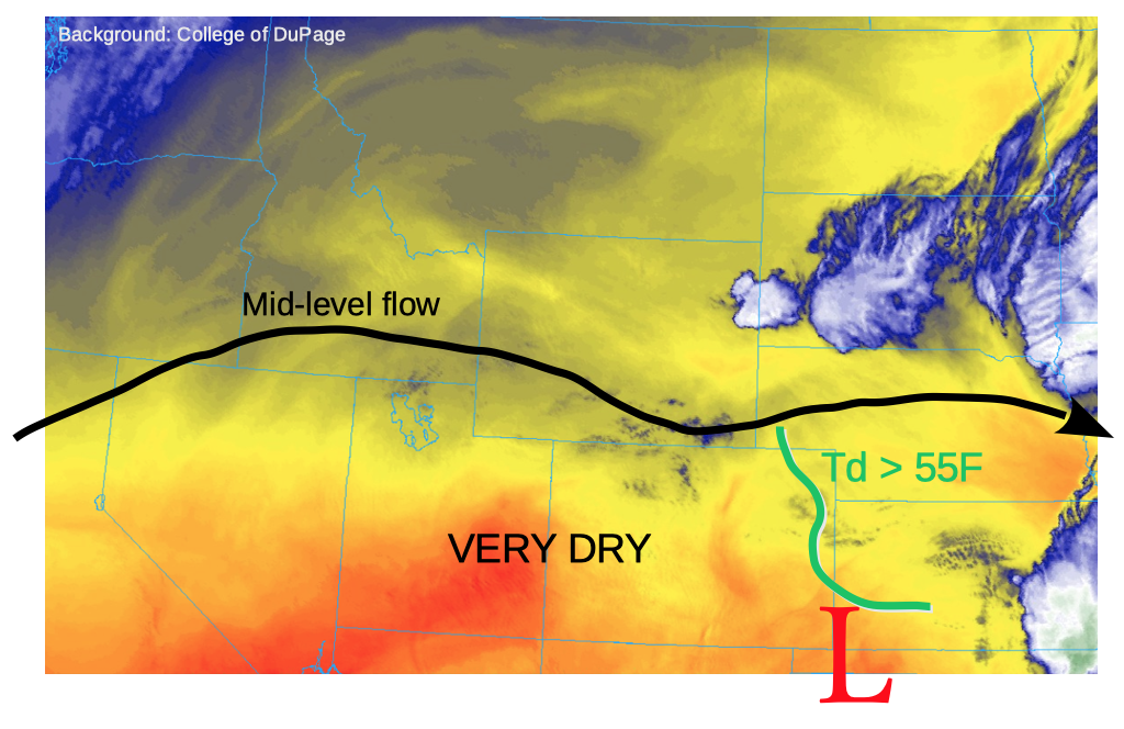
Over eastern Colorado a lee trough sets up, which will create a dry line type feature over the eastern plains and mix out moisture back to its west. With dew points in the 60Fs to the east of this line, storms that move into the area or fire along the dry line will be capable of producing local, heavy rainfall even with moderate storm motion to the southeast. A few severe storms are likely with the main threats being large hail (up to 2 inches) and strong outflow winds, but a weak tornado may also be possible. A Low flood threat has been issued for the area from about 4PM to 11PM.
A second wave of weak storms will likely arrive to the western border later tonight. Upper dynamics associated with the shortwave to our northwest and mid-level energy rotating around the high will allow light rainfall to continue over the Northern, Central and San Juan Mountains through tomorrow morning. Flooding is not expected from these storms.
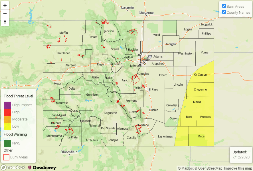
Today’s Flood Threat Map
For more information on today’s flood threat, see the map below. If there is a threat, hover over the threat areas for more details, and click on burn areas to learn more about them. For Zone-Specific forecasts, scroll below the threat map.
Zone-Specific Forecasts:
Southeast Plains, Northeast Plains, Palmer Ridge, Raton Ridge, & Urban Corridor:
A Low flood threat has been issued for the Southeast Plains as high dew points in the area will allow the severe thunderstorms to drop heavy rainfall. Max 1-hour rain rates just under 2 inches will be possible. The flash flood threats include flooding of local streams, roads, and low-lying areas. Local field ponding will also be possible. Large hail (up to 2 inches) and damaging outflow winds (up to 60 mph) will be possible under the severe storms that form with an outside chance of a weak tornado. The flood threat will start around 4PM and end around 11PM with lighter rainfall lingering a couple more hours.
Back west, as storms move off the mountains, max 1-hour rain rates will increase slightly to about 0.75 inches over the Palmer and Raton Ridges. Rain totals will be a bit lower over the lower elevation regions with surface moisture mixing out east throughout the day. Flooding is not anticipated with these storms.
Primetime: 1:30PM to 12AM
San Juan Mountains, Central Mountains, Northern Mountains, Front Range, Southeast Mountains, Northwest Slope, Grand Valley, Southwest Slope, & San Luis Valley:
The Grand Valley will have its first wave of storms arriving just after 11AM this morning, so expect some light showers and storm accumulation/coverage increasing by later this afternoon. Max 1-hour rain rates up to 0.15 inches will be possible over the lower elevations with the main threat from storms being gusty winds and lightning. Over the higher elevations, isolated 24-hour totals up to 0.25 inches will be possible with more general rainfall totals in the 0.10 to 0.20 inch range. Again, the main threat from the afternoon/evening storms will be wind gusts up to 45 mph, but dangerous lightning will also be possible (beware hikers). Over the eastern mountains, low-level moisture looks a little better, so max 1-hour rain rates up to 0.40 inches will be possible. The overnight storms over the western mountains mentioned in the discussion aren’t expected to drop much rainfall, and increased cloud cover will likely keep low temperatures a little higher than they would normally be. Flooding is not expected.
Primetime: 11AM to Ongoing