Issue Date: Saturday, July 11th, 2020
Issue Time: 8:55AM MDT
— Flooding is NOT expected today
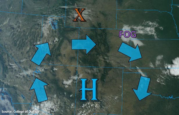
The visible satellite imagery below is showing some fog this morning over the northeast corner of the state where dew points are in the 60Fs. A little mixing and daytime heating should burn the fog off fairly quickly. Dry, westerly flow will continue over the state today with not much movement in the High from yesterday. This will again mix out the surface moisture from west to east throughout the day and place the higher dew points over the far eastern plains/southeast corner this afternoon. Some moisture has begun to make its way northward on the west side of the high (Utah, Arizona), and a disturbance over Wyoming (orange “X”) will swing south this afternoon with counterclockwise motion. This will help increase cloud cover across the norther border, but a decent cap at 700mb should keep storms from forming.
The cap may be able to break over the elevated regions of the Palmer and Raton Ridge, but even if a thunderstorm or two is able to pop, rain rates should be low enough to avoid flooding issues. With PW at 0.24 inches over Grand Junction (another daily record low), rainfall is not anticipated over western Colorado either.
Today’s Flood Threat Map
For more information on today’s flood threat, see the map below. If there is a threat, hover over the threat areas for more details, and click on burn areas to learn more about them. For Zone-Specific forecasts, scroll below the threat map.

Zone-Specific Forecasts:
Front Range, Southeast Mountains, Southeast Plains, Northeast Plains, Palmer Ridge, Raton Ridge, San Luis Valley, & Urban Corridor:
Temperatures over the plains will be slightly cooler today after a weak cold front moved through the area last night. It will be hard to notice the cooling as highs are still anticipated to be in the 90Fs. With dew points in the 50Fs over the far Southeast Plains and temperatures in the mid-90Fs, it’s to feel muggy once again. Expect cloud cover to increase across the northern border as the aforementioned disturbance moves south, which will bring a little relief from the afternoon heat. Thunderstorms are not anticipated over this area with the cap.
If a storm or two can break the cap over the Palmer Ridge and Raton Ridge, max 1-hour rain rates up to 0.50 inches will be possible along with gusty outflow winds. There is a better chance that only increased cloud cover occurs, but if the initial storms can produce a decent outflow boundary, it may be enough to help the subsequent cumulus break the cap. Flooding is not forecast.
San Juan Mountains, Central Mountains, Northern Mountains, Northwest Slope, Grand Valley, & Southwest Slope:
Fire danger is elevated over the region as it has been very dry, it will continue to be dry, and fuels are exceptionally dry. The spread of rapid fire growth is less today, since surface wind speeds should remain below 10 mph. Thus, there is no Red Flag Warning, but still use caution with open flames and avoid burning. As for temperatures, it’s going to be hot again. The Grand Valley could reach 100F+, so similar to yesterday with maybe even a slight uptick in the afternoon highs. Rainfall is not anticipated, but some broken afternoon cloud cover is likely over the higher elevations.