Issue Date: Thursday, July 9th, 2020
Issue Time: 10:10AM MDT
— A LOW flood threat has been issued for parts of the Northeast Plains
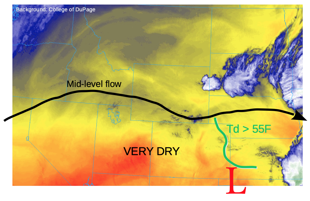
This morning’s water vapor imagery, below, shows a nearly zonal mid and upper-level flow is in place across the Rocky Mountain states. Very dry air is noted in Utah that will spread into western and central Colorado once again, limiting cloud cover and pushing temperatures above average again.
Things get more interesting farther east. A large cluster of storms is noted over South Dakota, which has sent a large-scale moist outflow boundary southwestward into eastern Colorado this morning. How moist? The Burlington observation station (Kit Carson County) is reporting a dew point of 63F under a low cloud deck. Meanwhile, the PW at Denver this morning was a meager 0.39 inches, well below normal, with a surface dewpoint of 33F! Farther east, the PW at North Platte (NE) was 0.88 inches, while Goodland (KS) measured an impressive 1.47 inches. In short, there exists a very sharp moisture gradient today across eastern Colorado. Furthermore, a surface low was noted over the western Oklahoma panhandle, which will re-develop further west in consistency with the warm season diurnal cycle in Colorado. This will help advect some of the aforementioned moisture back in the state. Instability, as measured by CAPE, will be in around 1,500 J/kg, though this number will be highly sensitive to the boundary layer moisture. A CAPE up to 3,000 J/kg would not be out of the question along the Kansas border. With 0-6km vertical wind shear increasing to 40+ mph today, there will be plenty of instability and dynamics to support rotating supercells. Large hail, up to 2.25 inches will be possible. The main limitation today will be the presence of a boundary layer cap that should limit storm coverage to the isolated/widely scattered variety.
Finally, regarding the threat of heavy rainfall, dewpoints above 55F are expected to persist along the NE/KS borders, with PW over 1 inch or even higher likely, at least locally. Our high resolution is suggested 40-60% chance of precipitation, though, it’s a setup where if storms fire, they will be capable of very heavy rainfall (along with the aforementioned severe weather). It appears the high-resolution guidance is underestimating rainfall rates today though precipitation chances look reasonable. Thus, a Low Flood threat is warranted for a small part of the Northeast Plains for this afternoon and into the overnight hours for isolated flash flooding and field/street flooding.
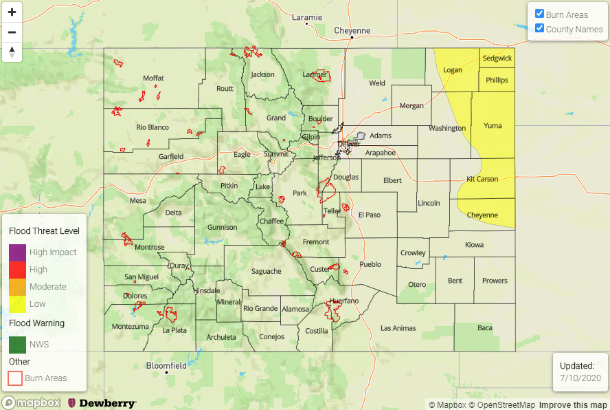
Today’s Flood Threat Map
For more information on today’s flood threat, see the map below. If there is a threat, hover over the threat areas for more details, and click on burn areas to learn more about them. For Zone-Specific forecasts, scroll below the threat map.
Zone-Specific Forecasts:
Palmer Ridge, Northeast Plains, Southeast Plains:
Sunny west, with low clouds early out east. Temperatures warming up quick with isolated to scattered showers and thunderstorms likely this afternoon. Max 1-hour rain rate up to 1.9 inches along the Kansas border warrants a small area with a Low flood threat. Main hazards will be isolated flash flooding with field and street flooding likely under the strongest storms. Hail up to 2.25 inches will also be possible, along with tornadoes, mainly of the landspout variety given the low humidity below the cloud base.
Primetime: 3PM to 1AM
Front Range, Urban Corridor, Southeast Mountains, Raton Ridge, Central Mountains, Northern Mountains, Northwest Slope, Grand Valley, Southwest Slope, San Juan Mountains, San Luis Valley:
Mostly sunny and very hot today with temperatures continuing to run up to 10F above normal. An isolated thunderstorm cannot be ruled out for far eastern areas over the Urban Corridor. However, max 1-hour rainfall will be below 0.5 inches and gusty winds are the bigger threat with these storms. Flooding is not expected today.
Primetime: 1PM to 9PM