Issue Date: Thursday, July 16th, 2020
Issue Time: 10:30AM MDT
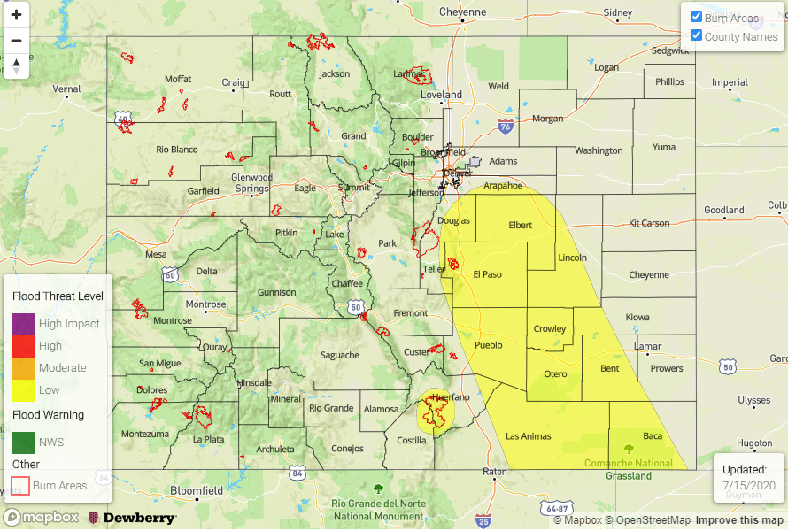
— A LOW flood threat has been issued for parts of the Front Range, Palmer Ridge, Southeast Mountains, Raton Ridge, Southeast Plains and San Juan Mountains
— A LOW flood threat has been issued for the 416 burn scar
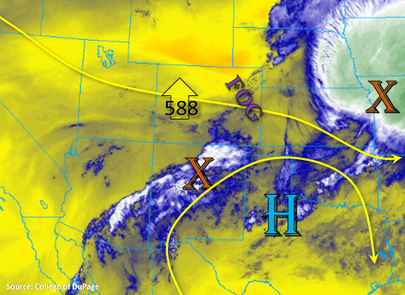
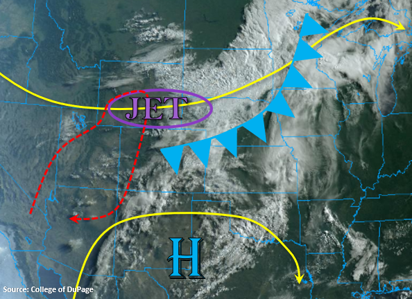
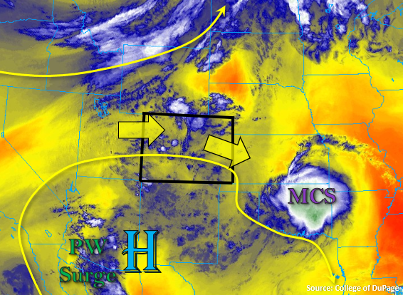
This morning’s visible satellite image, below, reminds us that monsoon season is here, even if its start has been modest. Within the clockwise flow around a strengthening upper-level ridge over Texas is an embedded rather strong but small-scale shortwave. Its southerly origin is a common feature of monsoon dynamics. It is already causing mainly mid and high clouds with some light showers over the Four Corners region. It is anticipated to slowly move across the southeast quadrant of Colorado today, causing scattered to numerous shower and thunderstorm activity for the third day in a row. Flood threat aside, no complaints for a region that has been plagued by a worsening drought.
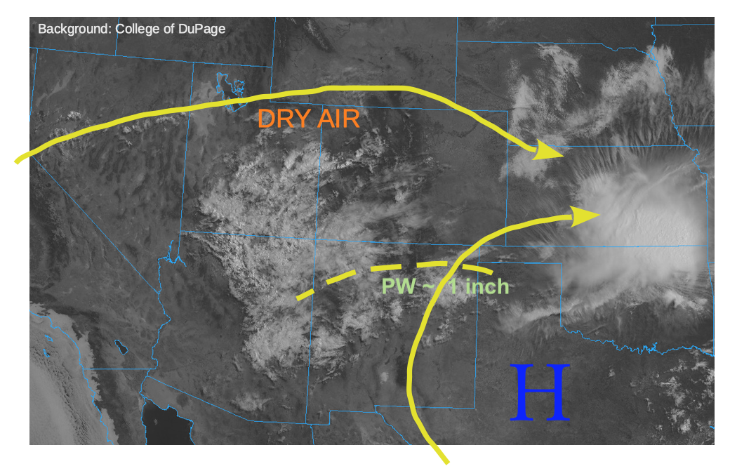
Taking a closer look at heavy rainfall parameters, a PW of 0.59 inches was measured at Denver this morning, which is below normal for this time of year. The Grand Junction radiosonde launch was not successful, but we estimate a PW of about 0.5 inches there, also below seasonal normal. However, the PW at North Platte, Nebraska (1.21 inches), Dodge City, Kansas (1.35 inches), and Albuquerque, New Mexico (1.00 inch) were all at or above seasonal normal. This implies that a strong moisture gradient exists to our south and east. Most notable is the value from Albuquerque, since that is where today’s air mass will be coming from. Importantly, it appears model initialization is underestimating the moisture content in northern New Mexico today, with model estimate PW of about 0.85-0.90 inches at Albuquerque, about 15% below the observed value.
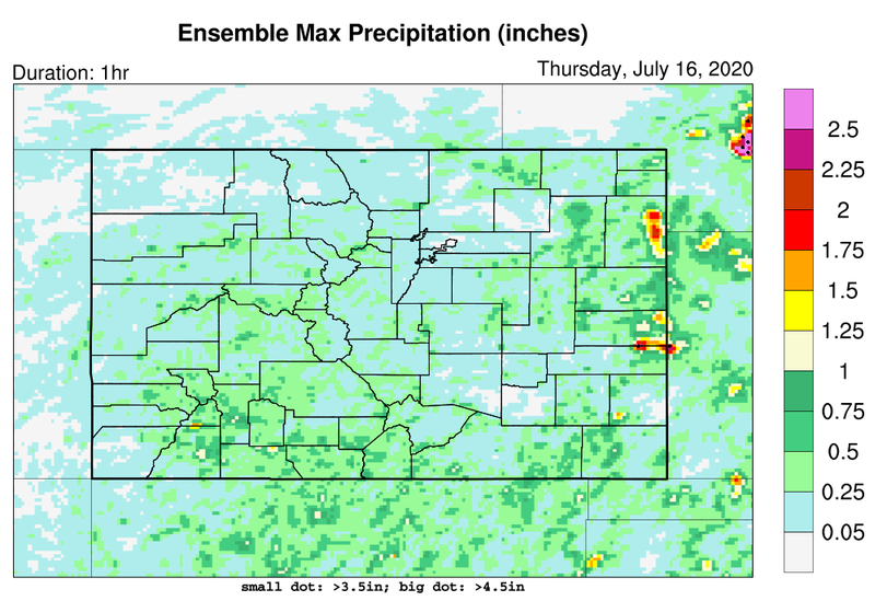
A look at our high-resolution guidance today shows underwhelming maximum 1-hour rainfall intensity (see below). Keeping in mind guidance is almost always biased high across the San Juan Mountains, it appears that guidance is underestimating rain intensity east of the Continental Divide. This is likely because of the propensity to mix out low-level moisture too quickly at this point in the summer. Accounting for this, we are issuing a Low flood threat for a large portion of southeast Colorado, but also including the eastern part of the San Juan mountains today. The 416 burn scar is also under a Low threat, because of the potential for multiple bursts of short-term heavy rainfall that will elevate the threat for mud flows.
East of the Continental Divide, large hail will also be possible with the strongest storms along with a slight chance of tornadoes.
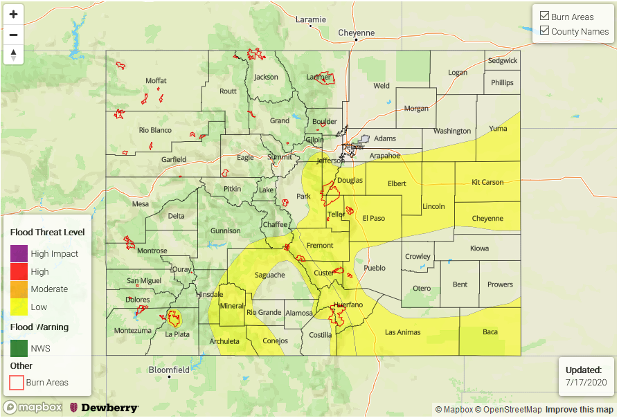
Today’s Flood Threat Map
For more information on today’s flood threat, see the map below. If there is a threat, hover over the threat areas for more details, and click on burn areas to learn more about them. For Zone-Specific forecasts, scroll below the threat map.
Zone-Specific Forecasts:
San Juan Mountains, San Luis Valley, Southeast Mountains, Palmer Ridge, Southeast Plains, Raton Ridge:
Increasing clouds with scattered to numerous showers and thunderstorms likely by noon. First over the higher terrain, then spreading eastward by mid-afternoon. Max 1-hour rainfall up to 2.2 inches out east and 1.4 inches in the higher terrain, except up to 1.1 inches in the San Juan Mountains. We expect several rounds of storms today, lasting later than normal into the evening due to the upper-level dynamical support. A Low flood threat has been issued by isolated flash flooding, street and field flooding, as well as mud flows and debris slides over steeper terrain. The 416 burn scar is also included in this Low threat. Large hail will be possible with the strongest cells, especially in eastern areas below about 6,500 feet.
The Fountain Creek basin will need to be watched carefully this afternoon, as it has received several days of heavy rainfall, causing saturated soils. While we do not expect it to enter flood stage today, it may come close.
Primetime (San Juan Mountains): 11AM-11PM
Primetime (east of Continental Divide): 2PM-3AM
Grand Valley, Central Mountains, Front Range, Urban Corridor:
Becoming partly cloudy with isolated to scattered showers and thunderstorms possible this afternoon. Much warmer than Wednesday, with highs near seasonal normal today. Max 30-minute rainfall up to 0.7 inches (east of Continental Divide) and 0.5 inches (west of Continental Divide), but flooding is not expected today. Gusty winds will be possible with the strongest storms.
Primetime: 12PM-9PM
Northwest Slope, Northern Mountains:
Mainly sunny with a few clouds possible later today. Isolated storms will be possible, mainly above 8,000 feet. Max 1-hour rainfall up to 0.4 inches. Gusty winds up to 40mph will be possible with the strongest storms. Flooding is not expected today.