Issue Date: Tuesday, July 14th, 2020
Issue Time: 9:30AM MDT
— A MODERATE flood threat has been issued for the Southeast Plains
— A LOW flood threat has been issued for the Palmer Ridge and portions of the Urban Corridor, Northeast Plains, and eastern Raton Ridge
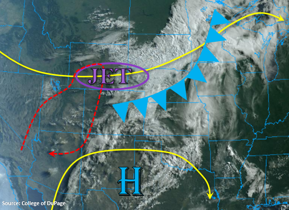
Not much change in the overall synoptic set up from yesterday. The trough will continue to pass to our north and the high will be pushed south, so Colorado will remain under westerly flow aloft. Taking a look at the water vapor imagery below, there are some subtle changes with the details. First, the jet will sit just north of the border. This will help produce faster, westerly surface winds over western Colorado and the mountains. PW will continue to drop off over western Colorado as a drier air mass is entrained, and with relative humidity values falling between 10 and 15%, critical fire weather is anticipated. A Red Flag Warning has been issued for the region in red below. Mid-level energy will continue to move across the western border, so weak storms are forecast again across the western high terrains. Overall, rainfall totals and coverage are expected to decrease, and strong outflow winds (50 mph) should be anticipated once again.
Back to the east, a cold front has started to drop south over the plains. This will help return low level moisture, which can be seen by the increase in cloud cover on its north side. Additionally, there will finally be a break in the hot temperatures over the northeast quadrant of the state, and afternoon highs are expected to drop off ~15F! The front will continue to drop south through tonight, and very high dew points will fill in over the eastern plains (60F). With plenty of lift from shortwaves moving through the flow overnight and concentrated lift along the front, a Moderate and Low flood threat have been issued. While the northeast corner of the state is expected to remain capped today, the Low threat has been extended back west to pick up any overnight convection firing over the Cheyenne Ridge due to extra dynamics in the area.
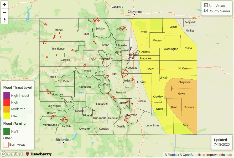
Today’s Flood Threat Map
For more information on today’s flood threat, see the map below. If there is a threat, hover over the threat areas for more details, and click on burn areas to learn more about them. For Zone-Specific forecasts, scroll below the threat map.
Zone-Specific Forecasts:
Southeast Plains, Northeast Plains, Palmer Ridge, Raton Ridge, & Urban Corridor:
A Moderate flood threat has been issued for the Southeast Plains as the cold front drops south overnight through the area. Storm totals just over 2.5 inches are possible, which would cause local stream flooding, road flooding, and flooding of low-lying areas. Additionally, severe thunderstorms are expected to develop over the plains, and these storms will be capable of producing 60 mph gusts and large, damaging hail. In the Low threat area (east), max 1-hour rain rates up to 1.50 will be possible with totals just over an inch forecast over the Palmer Ridge. Storm motion will be more easterly this afternoon and overnight, and the flood threat is expected to end just after midnight.
Primetime: 1PM to 1AM
San Juan Mountains, Central Mountains, Northern Mountains, Front Range, & Southeast Mountains:
It has started to dry out west of the Continental Divide, but there will still be some moisture left for some high-based, convection over the high mountain peaks with shortwaves moving through the flow. Expect coverage of storms to decrease when compared to yesterday as well. The main threat from the stronger storms that form will be again be outflow winds (50 mph gusts), and max 1-hour rain rates will decrease to 0.25 inches (north/central) and 0.15 inches (south).
Over the eastern mountains, coverage of storm coverage will be greatest along the Divide (north), northern Southeast Mountains, and Front Range/Palmer Ridge intersect. Max 1-hour up to 0.50 inches (north foothills) and 0.15 inches (south) are forecast. Flooding is not expected, and light showers may linger over the Central Mountains through 11PM.
Primetime: 12:30PM to 11PM
Northwest Slope, Grand Valley, Southwest Slope, & San Luis Valley:
Critical fire weather is forecast for these western regions with spotty critical fire weather anticipated for the San Luis Valley. Westerly winds will pick up to 10 to 15 mph by noon with gusts up to 30 mph. Relative humidity will drop off to 10 to 15%, so conditions will be favorable for the rapid ignition, growth and spread of fires. NWS Grand Junction has issued a Red Flag Warning, and please use caution with open flames. Rainfall is not forecast, and high temperatures should reach the mid to upper 90Fs over the lower elevations with high 80Fs for the San Luis Valley.