Issue Date: Wednesday, July 15th, 2020
Issue Time: 9:30AM MDT
— A LOW flood threat has been issued for the southern Urban Corridor, Palmer Ridge, Southeast Plains and Raton Ridge
— A LOW flood threat has also been issued for the Spring Creek burn area
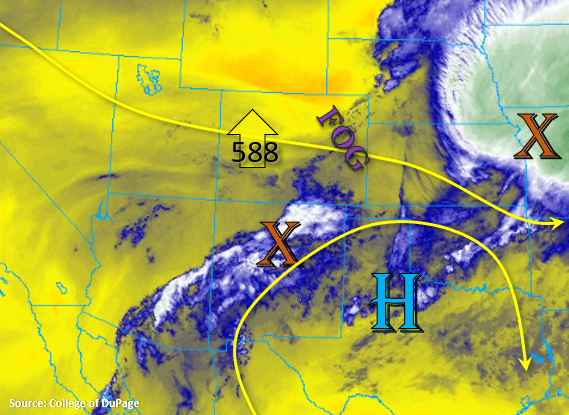
A large MCS can be seen to our east in the image below (orange “X” over KS/MO), which originated from the cluster of storms over the Southeast Plains yesterday. Today, the high will start to strengthen over Texas and push the 5880m height contour northward, so Colorado will be under moderate west/southwest flow aloft. This morning, there is quite a bit of fog over the eastern Plains, Palmer Ridge, and portions of the Urban Corridor. This should start to break up over the next couple of hours with a little daytime heating. The fog indicates that there is still plenty of low-level moisture still over eastern Colorado, and the sounding at Denver measured PW at 0.69 inches (note that the balloon popped at about 9km). Slightly higher PW values are present over southeast Colorado, and easterly flow at the surface this afternoon will keep surface moisture in place for another round of scattered afternoon storms. Looks like a cap across northern Colorado will keep rainfall chances low, so the storm activity this afternoon will generally along and south of I-70.
With the high to the southeast, mid-level energy and moisture from New Mexico (orange “X”) should move north across the southern border. Therefore, storms are also expected to return to the San Juan and Central Mountains this afternoon, and rainfall chances also increase for the San Luis Valley with more westerly steering flow. Due to higher moisture in the area, rain rates up to 0.5 inches will be possible over the Southeast Mountains. Therefore, a Low flood threat has been issued for the Spring Creek burn area. As the storms move off the mountains, rain rate efficiencies are predicted to increase due to an uptick in low-level moisture and better dynamics. So expect growing coverage of thunderstorms with a few becoming severe, and storms steering more to the southeast over the plains. A Low flood threat has been issued for urban flooding, road flooding, and flooding of low-lying areas.
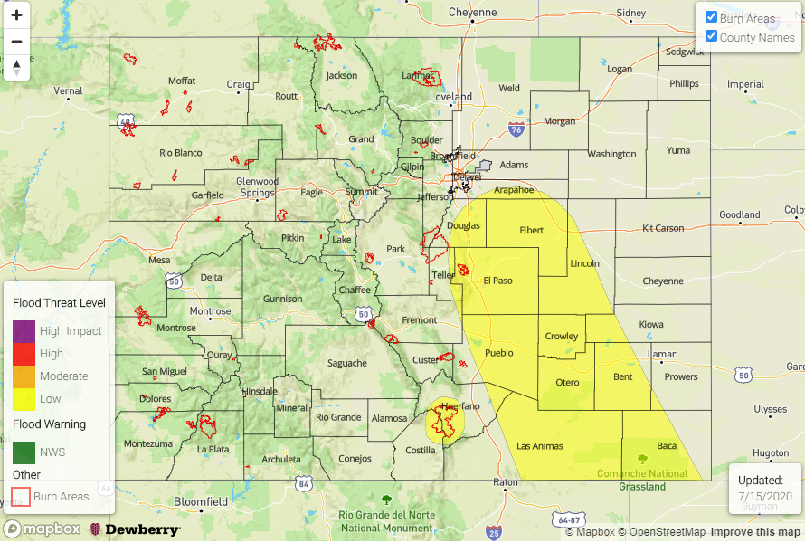
Today’s Flood Threat Map
For more information on today’s flood threat, see the map below. If there is a threat, hover over the threat areas for more details, and click on burn areas to learn more about them. For Zone-Specific forecasts, scroll below the threat map.
Zone-Specific Forecasts:
Southeast Plains, Palmer Ridge, Raton Ridge, & Urban Corridor:
A Low flood threat has been issued for the adjacent eastern plains this afternoon, and a few severe thunderstorms will be likely. Max 1-hour rain rates up to 1.9 inches will be possible in the threat area, so urban flooding, road flooding, and small stream flooding will be possible. There should be plenty of time for Fountain Creek to recover from the storms yesterday, but always a good idea to keep an eye on this one during heavy rainfall events. Severe thunderstorms that form will be capable of producing severe hail and strong outflow winds. Be sure to follow NWS Pueblo for the latest on storm warnings. Rainfall should start to come to an end just after midnight. High temperatures will drop off a bit behind the cold front, but rise 5-10F over the northern Urban Corridor and portions of the Palmer Ridge.
Primetime: 1:30PM to 12AM
San Juan Mountains, Central Mountains, Front Range, San Luis Valley, & Southeast Mountains:
Best chance for thunderstorms and rainfall today will be south of I-70. Max 1-hour rain rates just over 0.50 inches will be possible with totals decreasing over the San Luis Valley. Isolated totals (along the edges of the valley) up to 0.25 inches will be possible by tomorrow with more general totals in the 0.10 to 0.15 range. Storms will again be capable of producing gusty outflow winds and dangerous lightning if hiking.
Primetime: 12:30PM to 1AM
Northern Mountains, Northwest Slope, Grand Valley, Southwest Slope, & Northeast Plains:
These areas should remain dry today with high temperatures increasing over the Northern Mountains and Northeast Plains (5-10F). Other regions high temperatures will be about the same as yesterday, which is still above average for this time of year. Widespread fire danger will decrease today due to an increase in moisture and lighter surface winds. However, spotty fire weather conditions may still occur over the Northwest Slope this afternoon.