Issue Date: Friday, July 24th, 2020
Issue Time: 11:00AM MDT
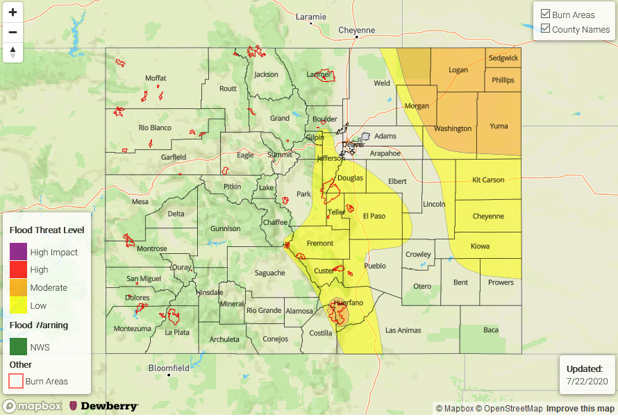
— A MODERATE flood threat has been issued for the Northeast Plains, Decker burn area, & 416 burn area
— A LOW flood threat has been issued for the Southwest Slope, San Juan Mountains, Grand Valley, Central Mountains, Northern Mountains, Southeast Mountains, San Luis Valley, Front Range, Urban Corridor, Palmer Ridge, Spring Creek burn area, & Lake Christine burn area
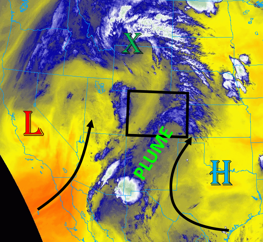
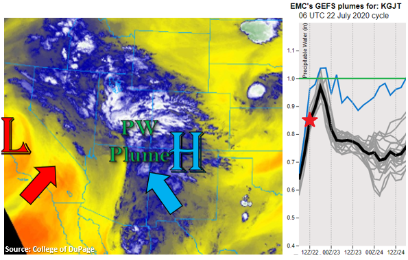
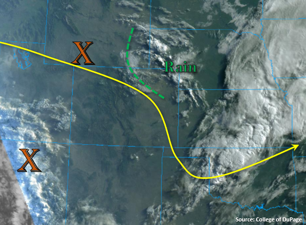
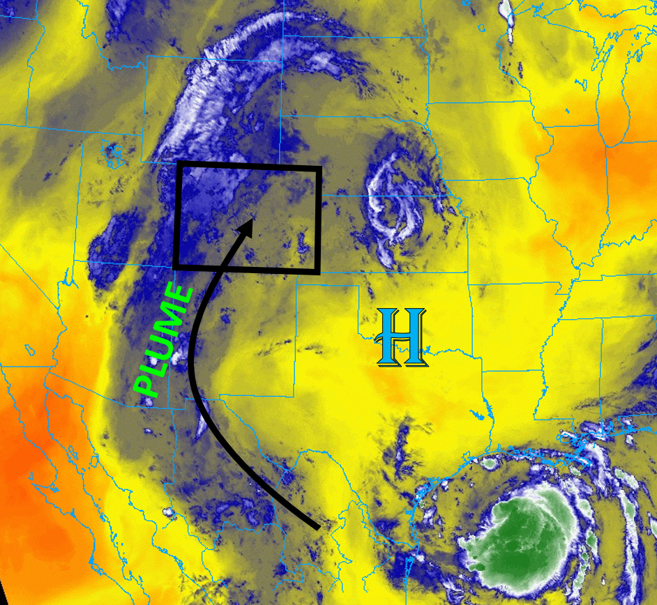
A plume of monsoon moisture can be seen draped across Colorado on the satellite water vapor image today (below) as a high pressure ridge is in place over the central plains of the US, which is continuing to pump moisture northward. This plume of moisture has boosted PW to 1.08 inches at Grand Junction and 1.06 inches at Denver in this morning’s soundings. A closer look at the Grand Junction sounding shows most of the entire depth of the troposphere is nearly saturated. The national radar image this morning shows showers over the western and northern part of the state, indicating some large-scale lift from stronger winds aloft is driving the precipitation. Surface dew points are in the 50Fs and low 60F across much of the state, with the 60Fs along the eastern plains and into the northern Urban Corridor. This low-level moisture is expected to largely remain in place today, which will provide the majority of the fuel for rainfall as clouds and early morning showers will likely cut down on strong surface heating for much of the western part of the state. This will limit the amount of instability over the mountains. Moderate southwesterly upper-level flow will cause storms and showers to track from southwest to northeast across the state today, which will limit the amount of time individual storms will be able to produce rain over an area. However, storms will track over the same locations throughout the day, increasing total 24-hour rain accumulation. As storms develop and track near the northeast corner of the state, heavy rainfall will be possible with the high low-level moisture present there.
Strong instability will not be able to build over much of the mountains today due to increased cloud cover and rain showers, especially over the northwestern corner of the state. However, over the far northeastern plains, higher instability is expected due to increased surface moisture as the lee trough supports moist south-southeasterly winds over the area. This instability, combined with some increased wind shear, could allow some severe thunderstorms to develop over the Northeast Plains. There is also the possibility of storms training in the area, so a Moderate flood threat has been issued. These severe storms could also produce gusty winds and hail.
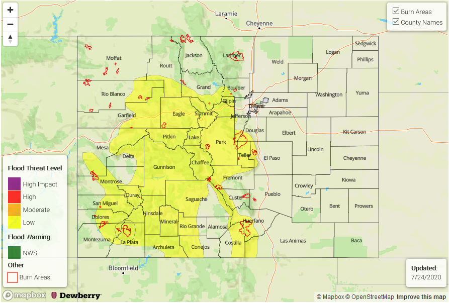
Today’s Flood Threat Map
For more information on today’s flood threat, see the map below. Hover over the threat areas for more details, and click on burn areas to learn more about them. For Zone-Specific forecasts, scroll below the threat map.
Zone-Specific Forecasts:
Southwest Slope, San Juan Mountains, Grand Valley, Northwest Slope, Central Mountains, Northern Mountains, Southeast Mountains, San Luis Valley, Front Range, Urban Corridor, Palmer Ridge, & Northeast Plains:
Showers and thunderstorms will track over the area from southwest to northeast for much of the day and into the overnight hours. This will allow precipitation to train over the same areas for extended periods. Max 1-hour rain rates up to 1 inch are possible where stronger storms can fire (in the clearings), and isolated 24-hour rain totals exceeding 1 inch are likely for the San Juan Mountains, northeastern Central Mountains, western Front Range, and southeastern Northern Mountains. The Lake Christine, and Spring Creek burn areas are also under a Low flood threat due to the abundance of moisture. A moderate flood threat is expected over the Decker and 416 burn areas due to increased likelihood of heavy 24-hour rain totals over 1 inch. If a stronger storm can form over a burn area, flooding of local streams, debris slides, and mud flows would be possible.
A couple severe storms are possible over the Northeast Plains, which could also produce strong winds and small hail. A Moderate flood threat has been issued for the area. Max 1-hour rain rates up to 1.5 inches will be possible. Threats from flooding include road flooding, field ponding, and local stream flooding.
Primetime: 11AM to 6AM
Southeast Plains & Raton Ridge:
Mostly sunny and warm today with high temperatures around 5F above normal. The monsoon moisture and upper-level energy will largely stay north and west of the area, limiting the chances for storms to develop. An isolated thunderstorm along the western Raton Ridge is not out of the question, but rain rates should stay below 0.75 in/hr.