Issue Date: Thursday, July 23rd, 2020
Issue Time: 09:45AM MDT
— A LOW flood threat has been issued for the Southwest Slope, San Juan Mountains, Southeast Mountains, Central Mountains, Grand Valley, Northwest Slope, Northern Mountains, and Front Range, including the 416 burn area
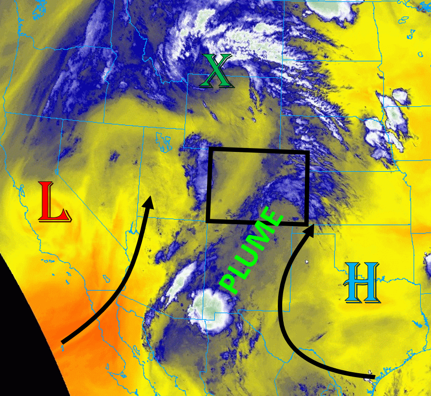
Colorado is situated between a trough along the US West Coast and a high pressure ridge to the east, as seen in the image below, which is allowing continued monsoonal moisture to be pumped northward into Colorado. The shortwave that moved through yesterday has moved north of Colorado (see image below), but the moisture that it brought is lingering across the state. PW from the Grand Junction sounding this morning is sitting at 1.01 inch, which is above the 90th percentile for the date. PW is slightly lower at 0.82 inch in Denver, but still above average. Additionally, dew points are in the low to mid 50Fs in the valleys of western Colorado as well as along the plains east of the Continental Divide. This moisture will allow plenty of instability to build, especially over the mountains. Upper-level southerly flow will generally weaken today, allowing storms to drift slowly northward and increasing the possibility of extended rainfall over areas. Due to the high chance of storms over the mountains, max rain rates up to 1 in/hr, and the potential for rainfall over a prolonged period, a Low flood threat has been issued for portions of the Southwest Slope, San Juan Mountains, Southeast Mountains, Central Mountains, Grand Valley, Northwest Slope, Northern Mountains, and Front Range.
Eastern Colorado will see some scattered thunderstorms develop this afternoon, but flooding is not expected. Dew points east of the Continental Divide are in the 50Fs, but surface moisture will decrease slightly during the day. Southerly winds will prevail over much of the plains of eastern Colorado, which will not be able to transport higher moisture from the east into western parts of the plains. Some isolated thunderstorms may be able to drop some heavy rain in the Southeast and Northeast Plains, but chances for storms are 50/50 today. Temperatures will be near normal east of the Continental Divide.
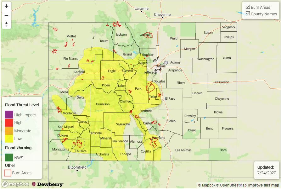
Today’s Flood Threat Map
For more information on today’s flood threat, see the map below. Hover over the threat areas for more details, and click on burn areas to learn more about them. For Zone-Specific forecasts, scroll below the threat map.
Zone-Specific Forecasts:
Southwest Slope, San Juan Mountains, Grand Valley, Northwest Slope, Central Mountains, Northern Mountains, Southeast Mountains, San Luis Valley, & Front Range:
Scattered thunderstorms will develop by noon over much of the high terrain, with higher chances for storms farther south. Max 1-hour rainfall up to 1 inch is possible over the Southwest Slope and San Juan Mountains, with 0.75 in/hr expected for mountain locations farther north and east. A Low flood threat is expected today over the higher terrain, including the 416 burn scar. Showers will likely linger well into the evening as continued moisture and energy is pumped into southern Colorado, which could boost 24-hour rain totals over the 1 inch mark for much of southwest Colorado.
Primetime: 12PM to Midnight
Northeast Plains, Urban Corridor, Palmer Ridge, Southeast Plains, & Raton Ridge:
Near-normal temperatures and some isolated thunderstorms are possible this afternoon and evening. Max 1-hour rain rates up to 1 inch are possible over isolated locations, but chances for storms are 50/50. The highest chances for storms are over the Palmer and Raton Ridge. Storms will move northeasterly off these ridge locations into the Northeast and Southeast Plains. Flooding is not expected today.
Primetime: 1PM to Midnight