Issue Date: Wednesday, July 22nd, 2020
Issue Time: 9:30AM MDT
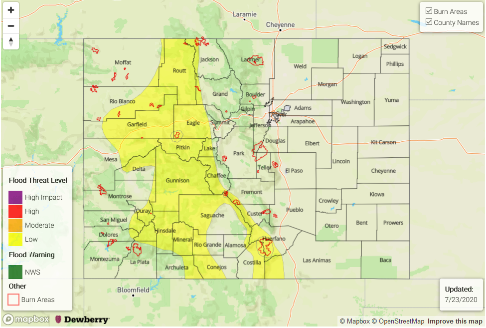
— A LOW flood threat has been issued for the Northern, Central, Southeast, and San Juan Mountains as well as portions of the Northwest Slope and Grand Valley. This threat area includes the Lake Christine, Decker, and Spring Creek burn areas.
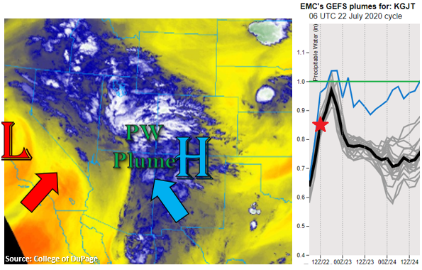
The flow around a Low, off the coast of California, and a High, over the southern border, are producing a well-defined subtropical moisture plume, which can be seen in the water vapor imagery below. Slight movement in the High has quickly elevated moisture values over western Colorado. This morning’s sounding measured PW at 0.85 inches (red star, right), which is up about 75% from last night! PW is forecast to reach close to an inch by this evening (GEFS plume forecast, right) as the High continues to be slightly displaced to the east by an incoming shortwave embedded in the southwest flow (over western Utah). This moisture and mid-level energy paired with the diurnal, upslope flow will return numerous showers and thunderstorms to western Colorado and the mountains today. Higher amount of rainfall are anticipated over the southern high terrains (including the Southeast Mountains), but the valleys, including the San Luis Valley, should also expect a little rainfall as the storms move off the mountains with the SSE steering flows.
Two factors will affect the rain rates today. The first is the heavy cloud cover over western Colorado, which may limit the area of instability for stronger thunderstorms. The other is a dry boundary layer, which may (initially) cause some extra evaporation of the rainfall. Nonetheless, trailing storms and a few stronger thunderstorms could accumulate totals capable of producing flooding. Thus, a Low flood threat has been issued. The Low flood threat includes the Lake Christine, Decker, and Spring Creek burn areas as rain rates in the area up to 0.50 inches will be possible with the stronger thunderstorms that develop.
Back to the west, surface moisture will begin to mix out over the adjacent plains and drier air will move into the eastern plains as the ridge begins to build overhead. Storm motion may push a couple storms into the immediate adjacent plains, mostly west of the I-25 corridor, but more wind than rain is anticipated with the storms.
Today’s Flood Threat Map
For more information on today’s flood threat, see the map below. If there is a threat, hover over the threat areas for more details, and click on burn areas to learn more about them. For Zone-Specific forecasts, scroll below the threat map.
Zone-Specific Forecasts:
Southeast Mountains, San Juan Mountains, Central Mountains, Northwest Slope, Grand Valley, Southwest Slope, Northern Mountains, & San Luis Valley:
The heavy rainfall threat has shifted back to the west and the mountains. Over the southern mountains (San Juans & Southeast), multiple rounds of rainfall may produce some flooding issues with totals up to 1.25 inches possible by morning. Where the sun can break through and build some instability for stronger thunderstorms, max 1-hour rain rates up to 0.75 inches will be possible. Further north, there is a better chance for some stronger thunderstorms. Max 1-hour rain rates up to 0.75 inches and a quick 0.50 inches in 30-min could cause localized flash flooding issues. Storms up north could also produce small hail and strong outflow winds today. A Low flood threat has been issued for the area, which includes the Lake Christine, Decker, and Spring Creek burn area. The valleys will also likely receive some rainfall today as storms move off the high terrains. Isolated totals up to 0.25 inches are not out of the question.
Primetime: 11AM to 1AM
Front Range, Raton Ridge, Southeast Plains, Palmer Ridge, Northeast Plains, & Urban Corridor:
The plains should stay quiet this afternoon with SSE steering winds, general subsidence, and a drying air mass, which will allow temperatures to quickly rise throughout the day. A few storms will be possible over the Front Range near the Divide, and isolated max 1-hour rain rates up to 0.40 inches will be possible with most storms producing, at most, around 0.25 inches. As storms move into the adjacent plains, expect strong outflow winds (up to 45 mph) to develop with a large dew point depression. The elevated regions of the Palmer and Raton Ridge may see isolated totals up to 0.20 inches, but most areas will receive below 0.15 inches.
Primetime: 1:30PM to Midnight