Issue Date: Tuesday, July 21st, 2020
Issue Time: 9:05AM MDT
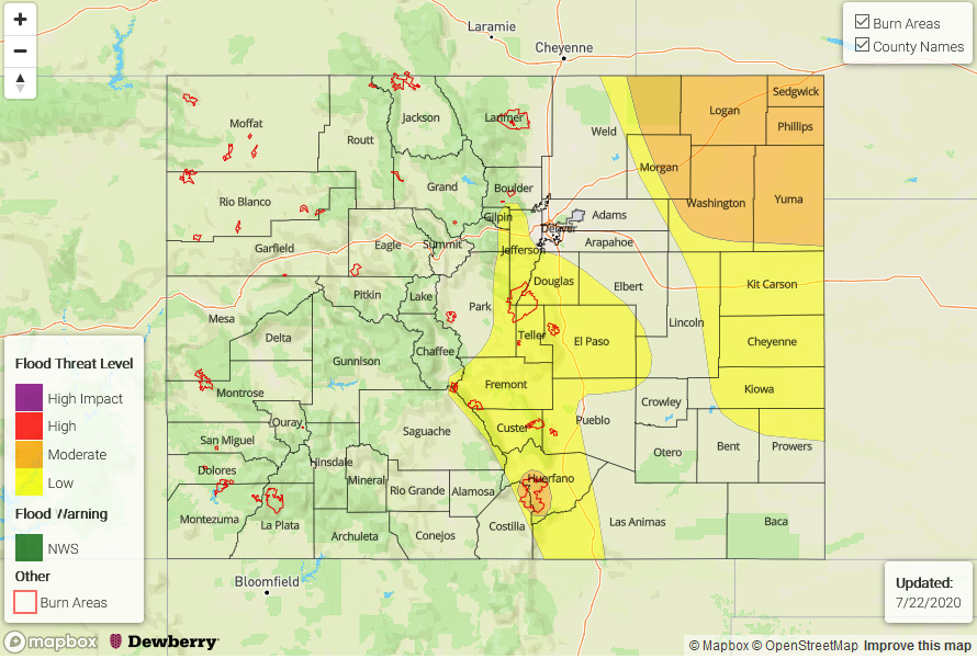
— A MODERATE flood threat has been issued for the Northeast Plains and Spring Creek burn area
— A LOW flood threat has been issued for the Southeast Mountains, southern Front Range, southern Urban Corridor, western Raton Ridge, Southeast Plains, and portions of the Palmer Ridge
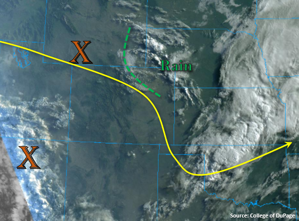
There are some morning showers to start the day over the far Northeast Plains, which are marked in the visible satellite imagery below. A moisture boundary has been pushed back west, and can be seen along the foothills (green dashed line). This has helped increase PW values across the area. Denver’s sounding didn’t quite make it past 12km this morning, but PW was still measured at 0.95 inches with a lot deeper moisture near the surface than the last few days. This should allow for more efficient rain rates this afternoon over the foothills and adjacent plains, rather than the high-based, windy convection we’ve seen the last couple of days. With flow aloft weaker, steering flow over eastern Colorado is also forecast to decrease, which should allow for some heavy rainfall accumulations this afternoon and evening favoring the southern high terrains and Palmer Ridge.
Afternoon surface winds are expected to turn east/southeasterly by early afternoon, and that will help reinforce and increase surface moisture, as well as help produce better shear values than yesterday. Today, a shortwave (orange “X” in WY) will move through the weak northwesterly flow aloft and help spark some widespread showers and thunderstorms over eastern Colorado. This means there will be a chance for some severe thunderstorms this afternoon and evening as storms track southeast. The best chances for a severe storm looks to be along and east of Highway 71. Initially, storms look capped over the Northeast Plains this afternoon, but storms from the north should track into the area by this evening and have no trouble producing some heavy rainfall, large hail, and another round of damaging wind gusts. A Low flood threat has been issued for the southern mountains/adjacent plains, which includes the Decker burn area. The slower steering winds and higher moisture pooled along the foothills also means there is an increased threat for flash flooding, mud flows and debris slides over the Spring Creek burn area. A Moderate flood threat has been issued for the area due to higher confidence 1 to 2-hour rain totals in the area will exceed 0.50 inches.
Back to the west, the best moisture looks to be over Utah and Arizona (the other orange “X”), but some residual moisture is expected to spark another round of high-based storms over the San Juan and eastern Central Mountains. Storms will again be capable of producing brief, strong winds and dangerous lightning with only light rainfall accumulations forecast. A second wave of energy (and moisture) looks to arrive to the Southwest Slope by early tomorrow morning, so some light rainfall over the southwest corner may be possible Wednesday morning.
Today’s Flood Threat Map
For more information on today’s flood threat, see the map below. If there is a threat, hover over the threat areas for more details, and click on burn areas to learn more about them. For Zone-Specific forecasts, scroll below the threat map.
Zone-Specific Forecasts:
Front Range, Southeast Mountains, Raton Ridge, Palmer Ridge, Urban Corridor, Northeast Plains, & Southeast Plains:
Looking at two areas of convection and heavy rainfall today. The first will be across the southern Front Range, Palmer Ridge, and Southeast Mountains. Sitting storms will likely produce rainfall totals just over 1 inch, and isolated totals up to 1.3 inches will be possible, which could cause flash flooding issues over urban areas as well as the steeper terrains. So, a Low flood threat has been issued, which includes the Decker burn area. Max 1-hour rain rates will likely exceed 0.50 inches over the burn area, so a Moderate flood threat has been issued. Threats include flash flooding of local streams and debris slides over the steeper terrains.
As storms move into higher moisture, instability, and upper level dynamics east, a few severe thunderstorms will be possible. The main threats will be local heavy rainfall (max 1-hour rain rates up to 2 inches), large hail, and another round of damaging wind gusts. A Low flood threat has been issued for the area. Additional storms this evening look to track across the border into an area that is expected to have very high dew points and instability (Northeast Plains). Max 1-hour rain rates up to 2.25 inches will be possible, which would cause local flash flooding issues. A Moderate flood threat has been issued for these severe thunderstorms that develop. Storms should end just before midnight.
Primetime: 5PM to 11PM
Northwest Slope, San Juan Mountains, Central Mountains, Grand Valley, Southwest Slope, Northern Mountains, & San Luis Valley:
Rinse and repeat patter for the San Juan Mountains and eastern Central Mountains. Max 1-hour rain rates up to 0.25 inches will be possible (southern San Juans) with most totals around 0.15 inches from the isolated storms that develop. Storms will again be capable of producing very strong wind gusts. The next plume of moisture arrives to the southwest corner by early tomorrow morning, so some light rainfall may be possible. Flooding is not forecast.
Primetime: 1PM to 9PM