Issue Date: Tuesday, July 28th, 2020
Issue Time: 10:55AM MDT
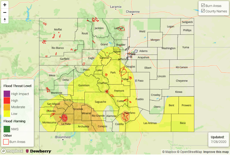
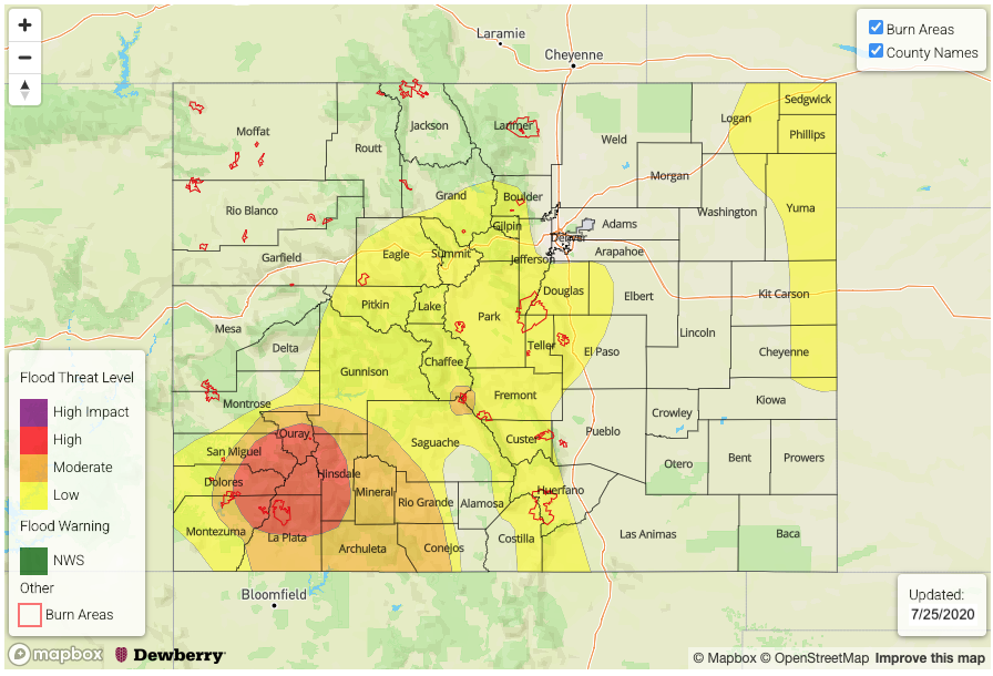
— A MODERATE flood threat has been issued for the Spring Creek burn area
— A LOW flood threat has been issued for the eastern Northern Mountains, eastern Central Mountains, Front Range, southern Urban Corridor, eastern San Juan Mountains, Southeast Mountains, Raton Ridge, Palmer Ridge, Northeast Plains, and Southeast Plains. This includes the Decker burn area.
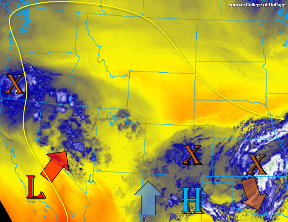
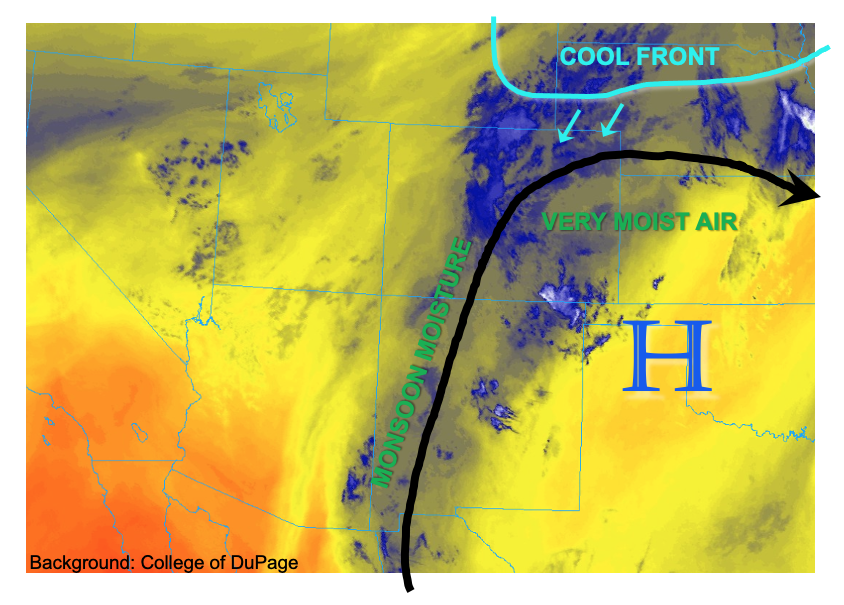
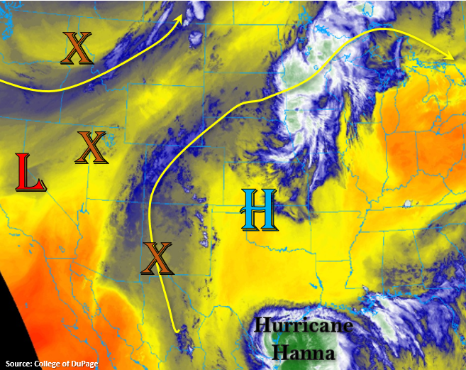
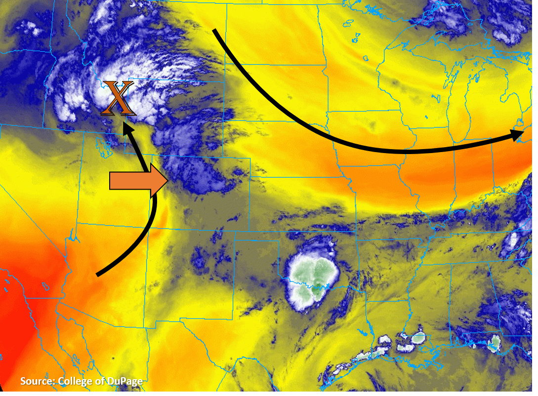
Today, Colorado is located just downstream of a shortwave trough (orange “X”), which will move from west to east across the state today and increase chances for more rain. Portions of this shortwave are causing lift and generating showers over the northwestern part of the state this morning, which are visible on the water vapor satellite image below. As this shortwave moves eastward during the day today, it will continue to cause rising motion and help initiate more storms over the mountains. The most widespread coverage looks to be north, associated with this feature, but more scattered storms are expected over the southern high terrain. These storms are expected to intensify as the wave moves eastward and into the plains of eastern Colorado this afternoon where higher moisture will exist.
The monsoon moisture that has been focused over Colorado the last several days is still in place, which can be seen by the blue shading on the water vapor satellite image below. PW remains above normal in the Denver (0.93 inch) and Grand Junction (0.98 inch) soundings this morning, and dew points remain in the 50Fs for many valley locations of the mountainous west and along the plains east of the Divide. However, behind the trough, drier air is moving in quickly, which will limit shower activity over western Colorado and the western mountains after the wave moves through. Over the eastern San Juan Mountains, the scattered storms may be able to produce slightly higher rain rates. Due to saturate soils and 4-day totals over 3 inches, a half inch in an hour or two span may help trigger mud flows and runoff into already high local rivers and streams.
Mid and upper-level winds will be increasing today as the shortwave moves across Colorado. This will cause storm motions to be fairly quick (20-40 mph), especially over the northwestern part of the state. However, this increased wind shear will likely allow storms to go more upscale and organize, especially over the eastern plains. Additionally, outflow boundaries from storms could help trigger additional convection in a high moisture environment. With more diurnal heating expected in this area, additional instability could build and provide additional fuel for heavy rain. So a Low flood threat has been issued over the Palmer & Raton Ridge and portions of the Northeast & Southeast Plains.
The Low threat has been extended over the Southeastern Mountains due to heavy rainfall the last few days helping to saturate soils. An additional 0.75 inches will be possible today, which could be enough to trigger isolated mud flows and debris slides if storms track over the more unstable soils. A Moderate flood threat has been issued for the Spring Creek burn area due to storms potentially being able to drop a quick 0.50 inches of rainfall over already unstable soils. Storms will push into the plains by early evening, so this is not an overnight threat for the burn area.
Today’s Flood Threat Map
For more information on today’s flood threat, see the map below. Hover over the threat areas for more details, and click on burn areas to learn more about them. For Zone-Specific forecasts, scroll below the threat map.
Zone-Specific Forecasts:
Northern Mountains, Central Mountains, San Juan Mountains, Southeast Mountains, & Front Range:
Numerous showers and thunderstorms are expected to develop over the high terrain and quickly move east. Max 1-hour rain rates up to 0.5 inch are possible over the high terrain near the Continental Divide. Due to multiple storms tracking over the same area, 0.75 inch of rain over a couple hours is possible. This falling on already moist soils, especially over the southern Front Range, could cause flash flooding and debris slides over steep terrain. A Low flood threat is expected over these high terrain regions.
Due to plenty of antecedent rain over the Spring Creek, a moderate flood threat is expected. Storms that fire over these locations could cause flash flooding, debris slides, and mud flows.
Primetime: 11AM to 8PM
Urban Corridor, Raton Ridge, Palmer Ridge, Northeast Plains, & Southeast Plains:
Over the plains east of the mountains, max 1-hour rain rates up to 1 inch are possible as storms go upscale and tap into increased moisture. Downslope winds just east of the Continental Divide will limit storm strength over the northern Urban Corridor. Storms should favor the higher Palmer & Raton Ridges, but outflow boundaries could initiate additional storms over the Northeast/Southeast Plains. A Low flood threat has been issued for these areas.
Primetime: 12PM to 11PM
Southwest Slope, Grand Valley, San Luis Valley, & Northwest Slope:
Some showers and storms may fire over the higher terrain, but flooding is not expected today due to drier air moving in aloft and storms moving east of these regions quickly. Max 1-hour rain rates should stay under 0.5 (0.25) inches for mountain (valley) locations.