Issue Date: Monday, July 27th, 2020
Issue Time: 10:45AM MDT
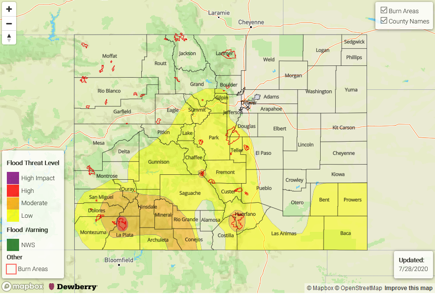
— A HIGH flood threat has been issued for the 416 burn area
— A MODERATE flood threat has been issued for the San Juan Mountains and the Spring Creek/Decker burn areas
— A LOW flood threat has been issued for the Central Mountains, southern Front Range, Southeast Mountains, Raton Ridge, and Southeast Plains
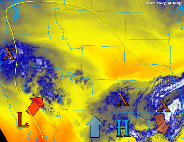
Fairly heavy cloud cover and fog over eastern Colorado to start the day, but some drier air has start to work its way into the mid-levels from the north. This can be visibly seen in the water vapor imagery (below) over northwest Colorado. An upper level trough and associated vorticity maximums (orange X’s in eastern CO/KS) will start to move slowly to the SSE throughout the day. This feature will produce more northerly flow across the northern border and eastern plains, and will help put a cap on afternoon convection over the majority of the eastern plains. PW values have also dropped slightly because of this at Grand Junction and Denver (0.92 inches and 0.85 inches, respectively). Still expecting some scattered storms to fire over eastern Colorado further south with the vorticity maximum/convergence area, and along the Raton Ridge. With slow steering winds, higher moisture in the area, and possible increased runoff from rainfall yesterday, a Low flood threat has been issued.
The shifting Low will cause the more southerly flow aloft over western Colorado to become more southwesterly. In turn, this will pull in higher moisture and mid-level energy into the area, including the southern Southeast Mountains, for another round of widespread, afternoon rain. Clearer skies over northwest New Mexico indicated that some instability may be able to form over the San Juan and southern Southeast Mountains later this afternoon for some weak thunderstorms, which could produce higher rain rates. With the drier air to the north, widespread showers and weak thunderstorms should stay south of I-70 for the most part over western Colorado. Over the last 72-hours portions of the San Juan Mountains and elevated regions south of them have received between 1.5 inches to 2.5 inches (more isolated), and some observations are nearing 3 inches. With higher rain rates anticipated this afternoon over saturated soils (increased runoff), the Moderate flood threat has been re-issued. With south facing slopes again likely to receive the heaviest rainfall, a High threat for the 416 burn area due to increased likelihood for heavier rainfall today. Threats include flooding of smaller rivers and local streams as well as the continued threat for mud and debris flows. Again, the latter can occur even with the rainfall is over. Reminder, that as the rainfall continues to accumulate over this event, it will take less precipitation to cause flooding issues and mud flows/debris slides.
Tonight, the rain south over the western San Juan should shift east, to areas along and near the Continental Divide, as the Low over California starts to rotate around the High. This will bring overnight rainfall chances back to the northern Southeast Mountains, so a Low flood threat has been issued. Since the Spring Creek and Decker burn area already had flash flooding issues yesterday and received ample rainfall, a Moderate threat has been issued due to an increased risk in mud and debris flows as well as runoff if storms form or track overhead.
Today’s Flood Threat Map
For more information on today’s flood threat, see the map below. If there is a threat, hover over the threat areas for more details, and click on burn areas to learn more about them. For Zone-Specific forecasts, scroll below the threat map.
Zone-Specific Forecasts:
San Juan Mountains, Southeast Mountains, Southwest Slope, Central Mountains, Front Range, Raton Ridge, & San Luis Valley:
Some heavier, widespread rainfall will be possible again this afternoon over the southern and eastern San Juan Mountains. 1-2 hour totals up to 0.75 inches or a quick 0.5 inches in 30-min will be possible with the stronger storms that develop. By morning, rain totals up to 1.5 inches will be possible in the Moderate area. With saturated soils, there’s an increased risk for mud/debris flows as well as local river/stream flooding from rainfall today. A High threat has been issued for the 416 burn area due to both the afternoon rainfall possible and totals by morning. Continue to watch local rivers and streams closely. The Navajo River reached 4.72 ft yesterday, nearing it’s 5.1 ft record, so flows remain elevated and are expected to quickly increase in areas that receive the heaviest precipitation. 24-hour totals along the southern end/edges of the San Luis Valley could reach 0.5 inches.
Over the Central, southern Front Range, and Southeast Mountains, long-lasting rainfall will be likely again today and tonight. Totals over the Central Mountains, southern Front Range, and northern Southeast Mountains up to 1.25 inches will be possible by morning; thus, the Low flood threat with a Moderate flood threat over the Spring Creek burn area. Over the southern Southeast Mountains, some stronger storms will be possible this afternoon/evening. Max 1-hour rain rates up to 0.75 inches will be possible, so a Moderate flood threat has been issued for the Spring Creek burn area in case these brush the southern end of the scar.
Primetime: 11AM to 4AM – This is an overnight threat!
Northern Mountains, Northwest Slope, Grand Valley, Urban Corridor, Southeast Plains, Palmer Ridge, & Northeast Plains:
Best chance for flooding today will be over the Southeast Plains with most other areas over eastern Colorado remaining dry and cool. If some instability is able to build in the Southeast Plains, mid-level energy/convergence could help break the cap and produce some stronger thunderstorms. Totals up to 1.75 inches will be possible, and if storms track over areas that received some of the heavier rainfall yesterday, increased field ponding and flooding of low-lying roads will be possible. A Low flood threat has been issued.
Very scattered storms are possible over the northwest corner of the state this afternoon. Max 1-hour rain rates up to 0.25 inches will be possible over the elevated regions. As the Low over California rotates around the High, some mid-level energy will move across this area tomorrow morning bringing showers and cooler temperatures. Flooding is not expected.
Primetime:
11AM to 9PM (Southeast Plains)
12PM to ongoing (Northwest)