Issue Date: Saturday, July 25th, 2020
Issue Time: 10:15AM MDT
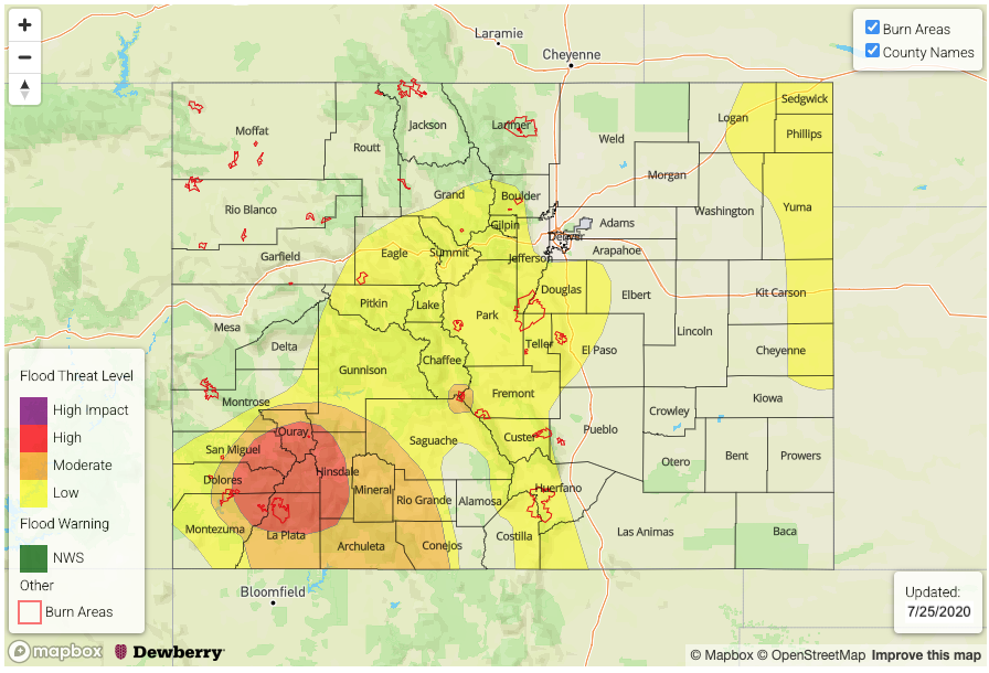
— A HIGH/MODERATE flood threat has been issued for the San Juan Mountains. This includes the 416 & Decker burn area. This threat continues overnight!
— A LOW flood threat has been issued for the Southwest Slope, Central Mountains, southern Front Range, Southeast Mountains, southern Urban Corridor and far Northeast/Southeast Plains. This includes the Lake Christine and Spring Creek burn areas.
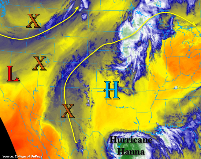
Western Colorado and the mountains are starting the day with heavy cloud cover. The moisture stream and embedded energy is continuing to stream in from the south, which is helping produce morning rainfall over portions of the Southwest Slope, Grand Valley, and Central Mountains. Western portions of the San Juan Mountains picked up another 0.50 to 1 inch yesterday (isolated totals closer to 1.5 inches), and gages in local streams and rivers are starting to rise. So, with steady rainfall continuing today and for the area, saturated soils will become a concern for increased runoff into local streams and mud/debris flows.
The evolution of the rainfall and storms will look similar to yesterday. Expect an uptick in rainfall coverage over the mountains by mid-day with the diurnal flow pattern. Extra mid-level energy is plenty (orange X’s), so rainfall is expected be widespread in the moisture rich environment. Then, storms will start to spill into the adjacent plains by early afternoon as Hurricane Hanna and passing trough to the north helps displace the High slightly westward. Additional storms will likely fire over the eastern plains as a shortwave moves through the flow with plenty of outflow boundaries in the area helping provide supplementary lift. A second wave of rainfall arrives for the overnight hours, and the axis of precipitation will shift eastward. This will put the northern Southeast Mountains and eastern San Juan Mountains under a flood threat overnight.
As for moisture and instability, not much change in the former. Soundings and dew points show elevated values, so this will keep rainfall efficiency higher. Instability will be limited over the mountains with the cloud cover, so stronger thunderstorms will again be most likely over the eastern plains. A Low flood threat has been issued for the eastern plains as training storms have caused localized flood issues the last couple of days. There is still the chance for isolated, weak thunderstorms over the mountains (slight breaks in the cloud cover), which would cause increased runoff with slightly higher rain rates. This is especially true if they track over an area with already saturated soils.
The main threat from this system over the southern mountains is the multiple days of steady rainfall. This will likely lead to flooding of local streams/creeks and mud flows/debris slides as the soil becomes unstable over the steeper terrains. A HIGH threat has been issued for the western San Juan Mountains for this reason, and highest rainfall totals are expected on the south facing slopes. This HIGH threat includes the 416 burn area. A Moderate threat has been issued for all of the San Juan Mountains and Decker burn area as the rainfall axis shifts to the east overnight.
Today’s Flood Threat Map
For more information on today’s flood threat, see the map below. If there is a threat, hover over the threat areas for more details, and click on burn areas to learn more about them. For Zone-Specific forecasts, scroll below the threat map.
Zone-Specific Forecasts:
San Juan Mountains, Southeast Mountains, Southwest Slope, & San Luis Valley:
Heavy rainfall will allow 48-hour totals to reach close to 3 inches over the western San Juan Mountains by morning. Small rock slides were already being reported yesterday, so the main threat over the next few days will be mud/debris flows from the saturated soils. Also, expect more rapid rises in local creeks/streams with the increased runoff. A HIGH flood threat has been issued for this region, which includes the 416 burn area.
As the plume of moisture and instability shifts east overnight, morning totals up to 1.25 inches will be possible over the northern Southeast Mountains and eastern San Juan Mountains. This could cause flash flooding issues over the Decker burn area, a Low/Moderate threat has been issued for this region. Looks like the San Luis Valley will also get some much needed rainfall, and isolated totals up to 0.50 inches are possible.
Primetime: 11AM to 8AM – This threat continues overnight!
Northern Mountains, Central Mountains, southern Southeast Mountains, Front Range, Raton Ridge, Southeast Plains, Palmer Ridge, Northeast Plains, & Urban Corridor:
Perhaps some better instability can build over these regions, and 1-2 hour totals up to 1 inch will be possible. A Low flood threat has been issued, which includes the Spring Creek and Lake Christine burn areas. Rather than an individual thunderstorm causing flash flooding, higher 24-hour totals may cause soils over the burn areas to become unstable.
Over the eastern plains (Northeast Plains & northern Southeast Plains), training storms will be possible again. These very high totals can cause local flash flooding issues as storms often continuously fire along outflow boundaries. Thus, the threat includes the high moisture area all along the eastern border as it is difficult to predict the outflow boundaries.
Primetime: 11AM to 8AM
Northwest Slope & Grand Valley:
These are the two areas that won’t see as much rainfall today, but light showers should be expected. Totals up to 0.50 inches will be possible along the higher terrains in both regions. So, over the Northwest Slope closer to mountains over the elevated plateaus. Flooding is not expected here.
Primetime: 11AM to 11PM