Issue Date: Sunday, July 26th, 2020
Issue Time: 10:15AM MDT
— A HIGH flood threat has been issued for the Spring Creek and Decker burn area
— A MODERATE flood threat has been issued for the 416 burn area
— A MODERATE/LOW flood threat has been issued for the Southeast Mountains and parts of the San Juan Mountains, Central Mountains, Front Range, Urban Corridor, Palmer Ridge, Southeast Plains, Northeast Plains and Raton Ridge
— Afternoon update possible today
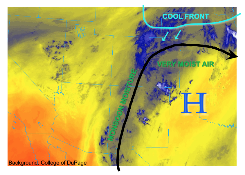
Today is expected to be one of the most active days for heavy rainfall across Colorado thus far this warm season. Let’s get right to the details. As shown in the water vapor image, below, many factors will be at play today, but as is often the case for Colorado, the most important one is by far moisture. This morning’s sounding analysis showed the following PW around the region: 1.24 inches at Denver, 1.02 inches at Grand Junction, 1.55 inches at Dodge City, 1.49 inches at North Platte (NE) and 1.25 inches at Albuquerque (NM). These values are well above seasonal normal, with a moist atmosphere extending from the surface to the tropopause. The high moisture content is the result of an extended plume of monsoonal moisture that has basically saturated the atmosphere from top to bottom over the past 48-72 hours. In addition to the monsoonal moisture, which typically favors areas west of the Continental Divide, a cool front is moving into eastern Colorado from the north. Although not particularly strong, it will provide just enough additional focus for boundary layer lift and increase storm coverage mainly over the Palmer Ridge and areas further south. Extremely heavy rainfall will be possible with this situation across the southeast quadrant of Colorado. A High flood threat is warranted for the Decker and Spring Creek burn scars with dangerous debris slides and mud flows possible over these areas, and just downhill from them. A Moderate flood threat is warranted for large parts of southeast Colorado, with the threat persisting well into the overnight hours. The only hesitation in going for a High flood threat is that cells are not expected to be particularly well organized, and the very heavy rainfall duration should generally be less than an hour. However, multiple rounds of very heavy rainfall are likely. Thus, an afternoon update will be possible today to address any increase in hazards.
In areas further west, the San Juan Mountains are again under a Moderate flood threat today as moist soils will contribute to increase runoff efficiency. With the consecutive days of heavy rainfall, the threat of mud flows and debris slides will increase today. Note that these can occur even when the rainfall is over.
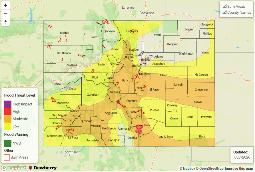
Today’s Flood Threat Map
For more information on today’s flood threat, see the map below. If there is a threat, hover over the threat areas for more details, and click on burn areas to learn more about them. For Zone-Specific forecasts, scroll below the threat map.
Zone-Specific Forecasts:
Southeast Mountains, Raton Ridge, Southeast Plains, Palmer Ridge, Northeast Plains:
Partly cloudy then scattered to widespread showers and thunderstorms forming over the higher terrain and then spreading into the lower elevations. Max 1-hour rainfall up to 3.1 inches (east0 and 1 inch (west). Max 3-hour rainfall up to 4.7 inches (east) and 2 inches (west). Flash flooding will be possible under the strongest cells, with debris slides and mud flows likely over the steeper terrain.
A High flood threat has been issued for the Decker and Spring Creek burn scars for this afternoon and evening. Dangerous mud flows will be possible over these areas.
A Moderate/Low flood threat has been issued for most of the region.
Note that isolated heavy rainfall will continue over the Southeast Plains well into the evening and overnight hours.
Primetime:
12pm-6am
San Juan Mountains, Southwest Slope, San Luis Valley, Central Mountains, Front Range, Urban Corridor, Northern Mountains, Grand Valley:
Partly cloudy then scattered to widespread showers and thunderstorms forming over the higher terrain and then spreading into the lower elevations. Max 1-hour rain rates up to 2.2 inches (east of the Continental Divide) and up to 1 inch (west of the Continental Divide).
A Moderate flood threat has been issued for isolated flash flooding, debris slides and mud flows in the San Juan Mountains and Central Mountains. Small stream flooding could be an issue over the San Juan Mountains, just like on Saturday.
Primetime:
12pm-9pm (west)
12pm-1am (east)
Northwest Slope:
Partly cloudy then isolated to scattered showers and thunderstorms possible this afternoon. Max 1-hour rainfall up to 0.6 inches. Flooding is NOT expected today.