FTB 08-25-2020: Increase in Afternoon Storm Coverage Over the Mountains

Issue Date: Tuesday, August 25th, 2020
Issue Time: 9:15AM MDT

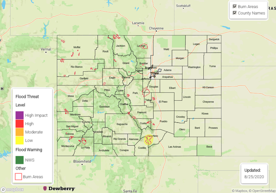
— A LOW flood threat has been issued for the Spring Creek burn area

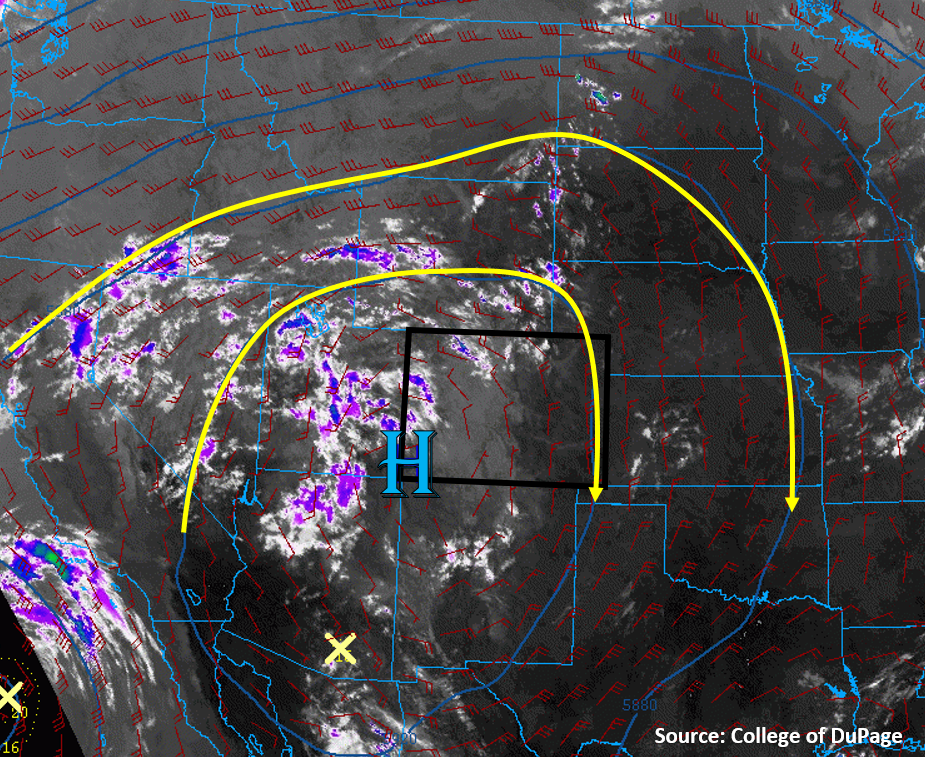
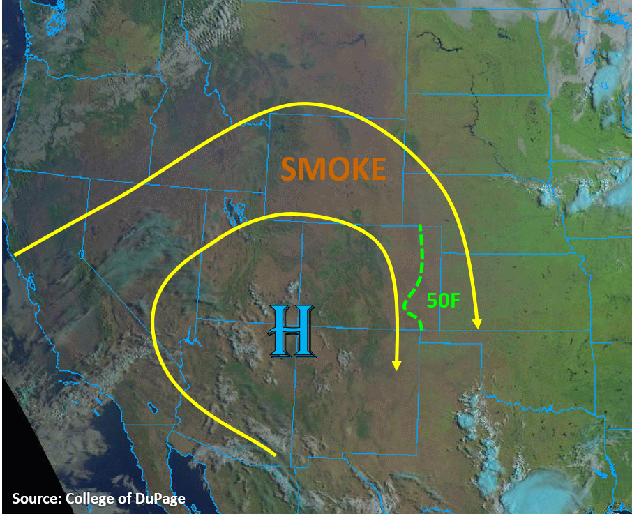
Today the pattern begins to shift slightly as some mid-level energy, associated with an incoming trough and remnants of Genevieve, start to move eastward. As these shortwaves move inland (area of cloud cover below), they should displace the ridge axis slightly eastward, which will start to pull some mid and upper level moisture into the state from the east (green oval). This means that rainfall efficiencies and coverage should start to increase with another round of scattered afternoon storms forecast over the mountains and western plateaus. The High itself doesn’t get displaced much, so expecting steering winds to be on the lower end again with the pop-like convection that forms over the higher terrains. CAPE also looks like it will increase when compared to yesterday, so there’s a better chance for some thunderstorms this afternoon over the mountains. While thunderstorms typically mean more wetting rainfall, some gusty outflow winds should also be expected (up to 40 mph) with the large dew point depressions along with lightning.

There will be a slightly greater PW surge over the southwest corner of the state as the High become oriented SW to NE, so expecting some higher totals in this area as well as over the southern Southeast Mountains. With higher totals and chances for precipitation forecast over the Southeast Mountains and Raton Ridge intersect, a thunderstorm could pop over the southern end of the Spring Creek burn area. A Low flood threat has been issued with isolated rain totals up to 0.70 inches possible, which could trigger some flash flooding and mud/debris flows onto Highway 12 if a storm forms overhead. Elsewhere, the rainfall should be gradual enough and heavier rainfall cores small enough that flooding is not expected.

Over the plains, a lee trough may produce a storm or two over the Northeast Plains if storms can break the cap. I would say the chances of this occurring are a little greater than the last couple of days with the extra mid-level lift moving into the area. Additionally, some storms could fire over the Cheyenne Ridge and move southeast across the border. Overall, storms should be on the weaker end, so flooding is not forecast.

Today’s Flood Threat Map

For more information on today’s flood threat, see the map below. If there is a threat, hover over the threat areas for more details, and click on burn areas to learn more about them. For Zone-Specific forecasts, scroll below the threat map.

Zone-Specific Forecasts:

Northern Mountains, Central Mountains, San Juan Mountains, Grand Valley, Southwest Slope, San Luis Valley, & Northwest Slope:

Increasing coverage of afternoon storms is expected over the mountains as well as the plateaus with some thunderstorms possible. It will likely be too dry to get much, if any, rainfall over the lower elevations, but the increased cloud cover should help a little with the heat. Isolated totals up to 0.2 inches (north), 0.5 inches (central), and 0.75 inches (south) will be possible by morning. Due to the large dew point depression and high DCAPE values, some strong outflow winds (up to 40 mph) will be possible along with lightning. Small hail may be possible with thunderstorms that form further south. Smoke will hang around with the lowest visibility expected over the Northwest Slope and Northern Mountains. Some lingering (light) precipitation is likely overnight as a second shortwave moves in from the west.

Primetime: 1PM to 3AM 

Southeast Mountains, Front Range, Palmer Ridge, Raton Ridge, Urban Corridor, Southeast Plains, & Northeast Plains:

Coverage of storms over the eastern mountains should increase this afternoon with max 1-hour rain rates up to 0.5 inches (north) and 0.75 inches (south) possible. Along with rainfall, gusty outflow winds and dangerous lightning are forecast. A Low flood threat has been issued for the Spring Creek burn area as chances increase for a storm forming over the southern end of the scar. The slow steering winds could also be an issue if a storm forms overhead.

As storms move off the mountains, the best chance for survival will be over the ridges with totals up to 0.3 inches possible. Additional storms may fire over the Northeast Plains either along a line of convergence (lee trough) or travel southeast from the Cheyenne Ridge. Max 1-hour rain rates up to 0.70 (east) will be possible, so flooding is not expected. Expect another day of hot temperatures all around.

Primetime: 12:30PM to Midnight

FTB 08-24-2020: Increased Moisture to Bring More Widespread Coverage of Storms over the Mountains

Issue Date: Monday, August 24th, 2020
Issue Time: 8:50AM MDT

— Flooding is NOT expected today

With little shift in the overall setup and ongoing fires, still plenty of smoke and haze across the state to start the morning (marked in the 7:45AM surface analysis below). A bit more moisture is also present as the remnants of Genevieve continue to move northward with PW measured at 0.73 and 0.65 inches at Grand Junction and Denver, respectively. Looking at dew points (green numbers below), Tds are still quite low with the 50F contour shown by the dashed green line. That means that this moisture is mostly located in the mid and upper levels of the atmosphere. So, while this increase in moisture will cause more coverage of storms over the mountains this afternoon, the dry sub-layer will limit the amount of precipitation reaching the ground, especially over western Colorado. The evaporation that will occur in this lower layer will also produce cooling and further sinking of the air, which will likely help produce some gusty outflow winds with the storms that do form. Slower steering winds with 500mb High anchored over the southwest border may allow for some higher accumulations, when compared to yesterday, but flooding is not expected. Expect most storms to dissipate as they move eastward off the mountains with the best chance for survival over the ridges.

Over the Northeast Plains another convergence line will set up associated with a surface low. Without an upper level jet or well-defined shortwave moving into the area this afternoon, it isn’t likely that storms will overcome the cap. However, a weak, isolated thunderstorms or two may be possible.

Today’s Flood Threat Map

For more information on today’s flood threat, see the map below. If there is a threat, hover over the threat areas for more details, and click on burn areas to learn more about them. For Zone-Specific forecasts, scroll below the threat map.

Zone-Specific Forecasts:

Front Range, Southeast Mountains, Palmer Ridge, Raton Ridge, Urban Corridor, Southeast Plains, Northeast Plains:

Best chance of storms today will be along and near the Continental Divide as well as over the Southeast Mountains. Max 1-hour rain rates up to 0.35 inches will be possible. Isolated totals up to 0.6 inches will be possible over the Northeast Plains and eastern Palmer Ridge if storms are able to fire or make it this far east off the mountains. With most storms dissipating as they move off the mountains, expect only trace amounts of rainfall along the I-25 corridor, so flooding is not expected. High temperatures will be similar to yesterday as the heat wave continues.

Primetime: 1PM to 9:30PM

Central Mountains, Northern Mountains, San Juan Mountains, Grand ValleySouthwest Slope, Northwest Slope, & San Luis Valley:

Although coverage of storms will increase, as well as relative humidity values, dry lightning and gusty outflow winds are a concern this afternoon. Best chance for wetting rainfall will be over the San Juan and eastern Central Mountains where isolated totals up to 0.4 inches (south) and 0.25 inches (north) will be possible. Elsewhere, expect only cloud cover and some brief sprinkles, so flooding is not expected. Air quality will continue to stay low and hot temperatures will continue.

FTB 08-23-2020: Weak Mountain Showers/Storms with Little Rainfall and Lots of Heat

Issue Date: Sunday, August 23rd, 2020
Issue Time: 09:25AM MDT

— Flooding is NOT expected today

Not much has changed in today’s weather setup compared to yesterday, as Colorado is still located under the high pressure ridge dominating the western US (see image below). The only difference today is that there is a little more mid-level moisture trapped within the anticyclonic flow around the center of the high pressure, which is showing up as more clouds (white, purple, & blue colors) in the IR satellite image below. This mid-level moisture is mostly over Utah currently, but it will circulate into Colorado today. What this means for Colorado is that more high-based mountains showers and isolated weak storms will develop with diurnal heating today. Soundings from Grand Junction and Denver indicate less moisture exists in the low-levels, with PW values similar to yesterday (0.52” to 0.57”). The lack of low-level moisture will keep the chance for precipitation over the high terrain. No flooding is expected today.

Dry air at the surface will allow temperatures to soar once again to near record levels across the state. Additionally, smoke from the numerous wildfires across the US West and Colorado will continue to lower air quality across Colorado today. Mixing of the boundary layer air with diurnal heating today will help improve surface air quality, but conditions will degrade overnight again.

Today’s Flood Threat Map

For more information on today’s flood threat, see the map below. Hover over the threat areas for more details, and click on burn areas to learn more about them. For Zone-Specific forecasts, scroll below the threat map.

Zone-Specific Forecasts:

Grand Valley, Northwest Slope, Northern Mountains, Central Mountains, Front Range, Southwest Slope, San Juan Mountains, Southeast Mountains, & San Luis Valley:

Diurnal heating will cause afternoon clouds and showers to develop over the high terrains this afternoon. A few locations may be able to develop enough instability for a few thunderstorms to fire, but rain rates should stay below 0.3 in/hr with these storms. The highest chances for showers and storms is again over the southern San Juan Mountains, where slightly higher dew points are present this morning. Storms could also produce some gusty winds up to 40 mph, which could impact wildfire containment efforts, but otherwise winds should stay fairly weak. No flooding is expected today.

Smoke will continue to impact the area and lower air quality. Outdoor activities should be limited today. Additionally, temperatures will be quite hot, with locations in the Grand Valley approaching the 100F mark. Be sure to stay hydrated.

Primetime: 12PM to 8PM

Northeast Plains, Urban Corridor, Palmer Ridge, Raton Ridge, & Southeast Plains:

Mostly sunny and hot with an isolated weak thunderstorm not out of the question during the afternoon and evening. Clouds from high-based storms drifting off the mountains could reduce sunshine over the Urban Corridor, but little to no rain accumulation is expected. Highest chances for rain will be over the Palmer Ridge, where max 1-hour rainfall up to 0.3 inches is possible. Flooding is not expected today.

Smoke continues to lower air quality, especially across the Urban Corridor. An Air Quality Alert has been issued by NWS, so driving gas/diesel vehicles and exercising outdoors is not recommended today. Temperatures will also rise into the upper 90Fs along the Urban Corridor and Northeast Plains, and into the low 100Fs along the Southeast Plains, potentially adding to the streak of record temperatures.

Primetime: 1PM to 8PM

FTB 08-22-2020: Weak Southern Mountains & Eastern Border Convection

Issue Date: Saturday, August 22nd, 2020
Issue Time: 09:45AM MDT

— Flooding is NOT expected today

Colorado is once again being influenced by the high pressure ridge over the US West. The center of the high pressure dome now sits over the 4 Corners area, which is transporting mainly smoke from California into eastern Colorado, as seen by the brown hue in the “natural” color satellite imagery below. This visible and IR satellite composite also shows that there are little to no clouds (white/blue colors) over or immediately upstream of Colorado, indicating mainly dry air is in place over the area. This morning’s soundings show that we are in a fairly dry airmass, with PW values near 0.5 inches. A bit more mid-level moisture is evident in the Grand Junction sounding, which will help some high-based showers and convection to develop over the central and southern mountains this afternoon. However, surface moisture remains weak, with the highest moisture lingering over the eastern plains (50Fs dew points). The placement of a lee trough over the eastern Colorado plains today will not allow strong upslope flow for western sections of the plains, but instead will allow some convergence near the Colorado/Kansas border. This will increase chances for a few isolated storms to fire in this area, which will have the best chances for moderate rain rates. Upper-level flow is generally weak over Colorado, but increases slightly from west to east. Even though these eastern border storms will have a bit more moisture and instability, the moderate upper-level flow will keep them moving into Kansas. Flooding is not expected today.

Air quality due to wildfire smoke is well into the unhealthy range this morning. With continued smoke streaming into the area, air quality issues will remain today.

Today’s Flood Threat Map

For more information on today’s flood threat, see the map below. Hover over the threat areas for more details, and click on burn areas to learn more about them. For Zone-Specific forecasts, scroll below the threat map.

Zone-Specific Forecasts:

Northeast Plains, Urban Corridor, Palmer Ridge, Raton Ridge, & Southeast Plains:

It will mainly be sunny and warm today, with temperatures approaching 100F over the Southeast Plains. A slight chance exists for a few storms to fire near the eastern Colorado border where a convergence boundary can produce enough lift to overcome the cap. Some surface moisture may be able to hang on (50F dew point) near the eastern border, which could allow up to an inch of rain to fall over a 2-hour period with storms that can anchor over the convergence boundary. However, moderate (10-20 mph) mid-level winds will push these storms southeast into Kansas. No flooding is expected with these eastern border storms.

Farther west, along the Urban Corridor and western portions of the Southeast Plains, a few clouds and storms may roll off the higher terrains into the region, but rain accumulations should be negligible along the Urban Corridor and up to 0.15 inches over the western Southeast Plains. No flooding is expected with these storms, but some gusty outflow winds up to 30 mph are possible.

Primetime: 1PM to 8PM

Grand Valley, Northwest Slope, Northern Mountains, Front Range, Central Mountains, Southwest Slope, San Juan Mountains, Southeast Mountains, & San Luis Valley:

Typical summertime heating will allow clouds and weak storms to form over the high terrains this afternoon. Some mid-level moisture trapped within the high pressure ridge will favor a higher chance for high-based storms over the central and southern mountains. Rain rates should remain below 0.2 in/hr for the Central Mountains and below 0.3 in/hr for the San Juan and Southeast Mountains as storms meander their way south. The highest likelihood storms and some accumulating rainfall is over the southern San Juan Mountains, where up to 0.5 inches of rain could fall over a few hours. No flooding is expected with these storms.

The Northern Mountains, Front Range, and Northwest Slope should mainly see clouds and smoke today. Luckily, surface winds will be weak today, so a Red Flag Warning was not issued today, but still be cautious if adventuring outdoors this weekend.

Primetime: 12PM to 8PM