Issue Date: Saturday, August 22nd, 2020
Issue Time: 09:45AM MDT
— Flooding is NOT expected today
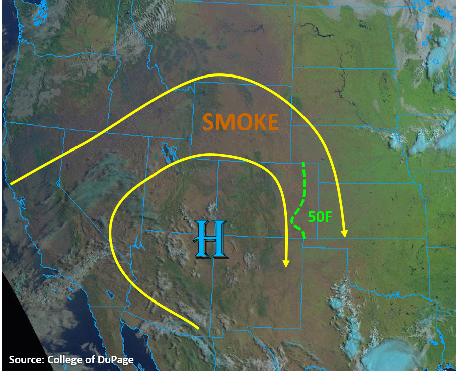
Colorado is once again being influenced by the high pressure ridge over the US West. The center of the high pressure dome now sits over the 4 Corners area, which is transporting mainly smoke from California into eastern Colorado, as seen by the brown hue in the “natural” color satellite imagery below. This visible and IR satellite composite also shows that there are little to no clouds (white/blue colors) over or immediately upstream of Colorado, indicating mainly dry air is in place over the area. This morning’s soundings show that we are in a fairly dry airmass, with PW values near 0.5 inches. A bit more mid-level moisture is evident in the Grand Junction sounding, which will help some high-based showers and convection to develop over the central and southern mountains this afternoon. However, surface moisture remains weak, with the highest moisture lingering over the eastern plains (50Fs dew points). The placement of a lee trough over the eastern Colorado plains today will not allow strong upslope flow for western sections of the plains, but instead will allow some convergence near the Colorado/Kansas border. This will increase chances for a few isolated storms to fire in this area, which will have the best chances for moderate rain rates. Upper-level flow is generally weak over Colorado, but increases slightly from west to east. Even though these eastern border storms will have a bit more moisture and instability, the moderate upper-level flow will keep them moving into Kansas. Flooding is not expected today.
Air quality due to wildfire smoke is well into the unhealthy range this morning. With continued smoke streaming into the area, air quality issues will remain today.
Today’s Flood Threat Map
For more information on today’s flood threat, see the map below. Hover over the threat areas for more details, and click on burn areas to learn more about them. For Zone-Specific forecasts, scroll below the threat map.

Zone-Specific Forecasts:
Northeast Plains, Urban Corridor, Palmer Ridge, Raton Ridge, & Southeast Plains:
It will mainly be sunny and warm today, with temperatures approaching 100F over the Southeast Plains. A slight chance exists for a few storms to fire near the eastern Colorado border where a convergence boundary can produce enough lift to overcome the cap. Some surface moisture may be able to hang on (50F dew point) near the eastern border, which could allow up to an inch of rain to fall over a 2-hour period with storms that can anchor over the convergence boundary. However, moderate (10-20 mph) mid-level winds will push these storms southeast into Kansas. No flooding is expected with these eastern border storms.
Farther west, along the Urban Corridor and western portions of the Southeast Plains, a few clouds and storms may roll off the higher terrains into the region, but rain accumulations should be negligible along the Urban Corridor and up to 0.15 inches over the western Southeast Plains. No flooding is expected with these storms, but some gusty outflow winds up to 30 mph are possible.
Primetime: 1PM to 8PM
Grand Valley, Northwest Slope, Northern Mountains, Front Range, Central Mountains, Southwest Slope, San Juan Mountains, Southeast Mountains, & San Luis Valley:
Typical summertime heating will allow clouds and weak storms to form over the high terrains this afternoon. Some mid-level moisture trapped within the high pressure ridge will favor a higher chance for high-based storms over the central and southern mountains. Rain rates should remain below 0.2 in/hr for the Central Mountains and below 0.3 in/hr for the San Juan and Southeast Mountains as storms meander their way south. The highest likelihood storms and some accumulating rainfall is over the southern San Juan Mountains, where up to 0.5 inches of rain could fall over a few hours. No flooding is expected with these storms.
The Northern Mountains, Front Range, and Northwest Slope should mainly see clouds and smoke today. Luckily, surface winds will be weak today, so a Red Flag Warning was not issued today, but still be cautious if adventuring outdoors this weekend.
Primetime: 12PM to 8PM