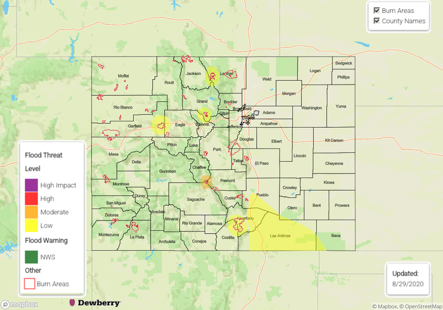
Issue Date: Saturday, August 29th, 2020
Issue Time: 10:40AM MDT
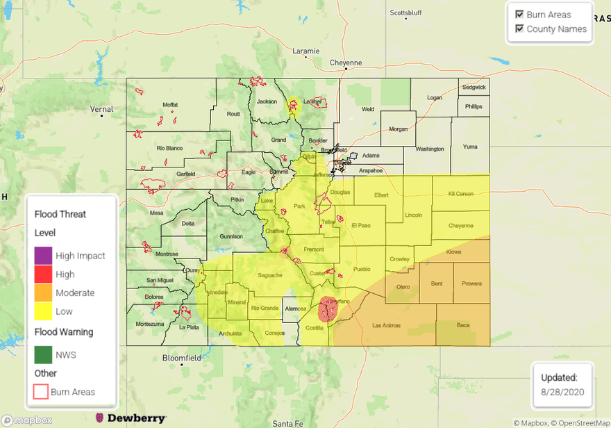
— A LOW flood threat has been issued for the Raton Ridge and southern Southeast Plains regions, as well as the Cameron Peak, Williams Fork, Grizzly Creek, and Spring Creek burn areas
— A MODERATE flood threat has been issued for the Decker burn area
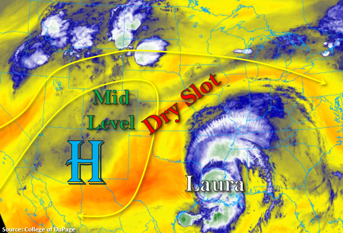
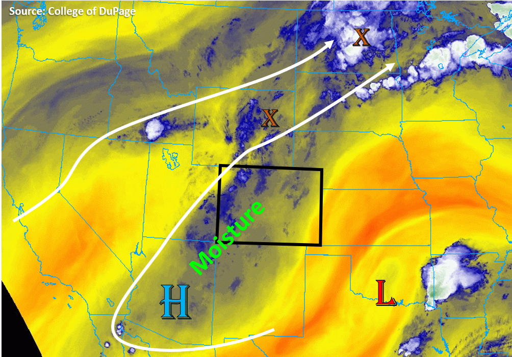
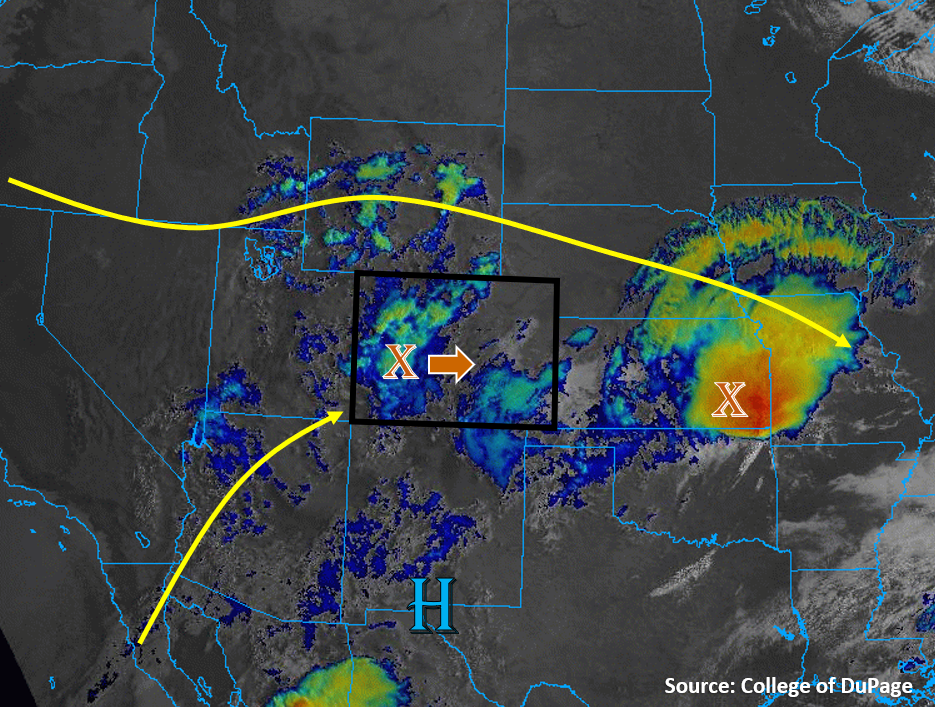
Abundant rainfall yesterday has added moisture to low-levels today, as surface dew points are in the 40Fs and 50Fs across the state, with 60Fs in southeast Colorado. The shortwave associate with the heavy rain over southeast Colorado yesterday can be seen moving through eastern Kansas this morning on the satellite image below (labelled with an “X”). Mid-level moisture also remains over Colorado today with a brief monsoonal flow setup. This has boosted PW values to 0.9 inches at Denver and Grand Junction when compared to this time yesterday. The bubble of moisture over the southwestern US is evident in the visible + IR “sandwich” satellite image this morning as the white, blue, and green colors (see image below). This moisture will allow widespread coverage of afternoon storms today.
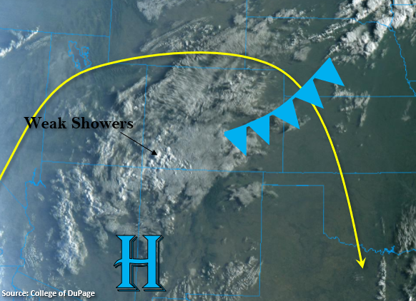
A batch of clouds and showers is moving through western Colorado this morning, which is associated with a piece of shortwave energy traveling through the flow. This shortwave will continue to move east during the day today, and it will be the focus of the heavier rainfall today. Mid-level winds are weak this morning over Colorado (10-15 mph), but winds will increase behind this shortwave later this afternoon (25-30 mph). This means storms that form earlier in the day will move slower, whereas storms later this afternoon should move east at a decent pace, which helps lower the chances for flooding. The clouds and showers over western Colorado will also act to keep temperatures cool and limit instability, so chances for heavy rainfall over the western slope are low today. The highest chances for heavy rainfall will be along the eastern mountains and plains where some daytime heating can increase instability before the shortwave moves overhead.
Due to plenty of moisture and some added lift from the shortwave, a Low flood threat has been issued for the Raton Ridge and southern Southeast Plains regions. Additionally, a Low flood threat has been issued for the more susceptible burn areas, including the Cameron Peak, Williams Fork, Grizzly Creek, and Spring Creek burn scars. A moderate flood threat has been issued for the Decker burn scar due to higher rain rates and increased coverage of storms.
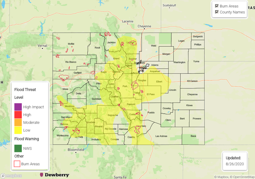
Today’s Flood Threat Map
For more information on today’s flood threat, see the map below. Hover over the threat areas for more details, and click on burn areas to learn more about them. For Zone-Specific forecasts, scroll below the threat map.
Zone-Specific Forecasts:
Northeast Plains, Urban Corridor, Front Range, Palmer Ridge, Raton Ridge, Southeast Mountains, & Southeast Plains:
Showers and clouds will move into the Front Range area by 11AM, which should limit storms early. A round of storms later in the day could move through, but rain rates should stay below 0.4 in/hr over the Front Range and Urban Corridor. A corridor of southerly flow adjacent to the high terrain will allow moisture to remain high along the plains adjacent to the mountains, but drier air along the northeast border of Colorado will cause storms to dissipate as they move farther east in the Northeast Plains. There is a chance a stronger storm may move southeast off the Cheyenne Ridge into the Northeast Plains, which could boost rain rates up to 0.9 in/hr, but these storms should move east fairly quickly due to increasing mid-level winds. No flooding is expected over these northern regions.
Storms will develop slightly later (by 1PM) over the Southeast Mountains as the shortwave moves east. Due to slightly higher surface moisture available over the Southeast Plains and some extra time for instability to build, the highest rain rates are expected there as storms move east off the mountains with the passing shortwave. Storms will likely grow upscale, further increasing coverage and rain rates. Max rain rates up to 1 in/hr are possible with the stronger storms that develop over the Palmer Ridge, Southeast Plains, and Raton Ridge. A cap should cause storms to struggle as they approach the eastern border. Due to the large amount of rain received over the Southeast Plains yesterday and the chance for some heavy downpours today, a Low flood threat has been issued for the Raton Ridge and southern portions of the Southeast Plains. Additionally, a Low flood threat has been issued for the Spring Creek burn area due to moist soils from yesterday’s rainfall and the high likelihood of storms moving across the area today with rain rates up to 0.5 in/hr possible.
Primetime: 11AM to 12AM
Grand Valley, Northwest Slope, Northern Mountains, Central Mountains, Southwest Slope, San Juan Mountains, & San Luis Valley:
Showers are moving through the Grand Valley, Central Mountains, and northern San Juan Mountains this morning, which will limit diurnal heating today for much of the area. However, once this batch of clouds and showers moves east, some afternoon storms will fire over the higher terrains. By then, some stronger mid-level winds will develop, so storms should not linger too long over areas. But, due to moderate surface and mid-level moisture, rain rates up to 0.7 in/hr are possible over the southern San Juan Mountains, where the highest surface dew points exists this morning (50Fs). Rain rates decrease further north and west, with up to 0.4 in/hr possible for the high elevations of the Central and Northern Mountains and the Flat Tops in the Northwest Slope. Due to the high likelihood of storms and moderate chances for rain rates over 0.25 in/hr, a Low flood threat has been issued for the new Cameron Peak, Williams Fork, and Grizzly Creek burn scars. A moderate flood threat has been issued for the Decker burn area, where slightly higher chances of receiving over 0.25 inches in an hour are expected. The Pine Gulch burn area should be far enough west that flooding rainfall is not expected, with rain rates under 0.2 in/hr. Flash flooding, mud flows, and debris slides are possible in these vulnerable burn scars.
Primetime: 10AM to 8PM