Issue Date: Wednesday, August 26th, 2020
Issue Time: 11:00AM MDT
— A LOW flood threat has been issued for the Northern Mountains, Front Range, Central Mountains, San Juan Mountains, Southeast Mountains, and Palmer Ridge.
— This threat includes recent burn areas: Spring Creek, 416, Decker, Lake Christine, Cameron Peak, and Williams Fork
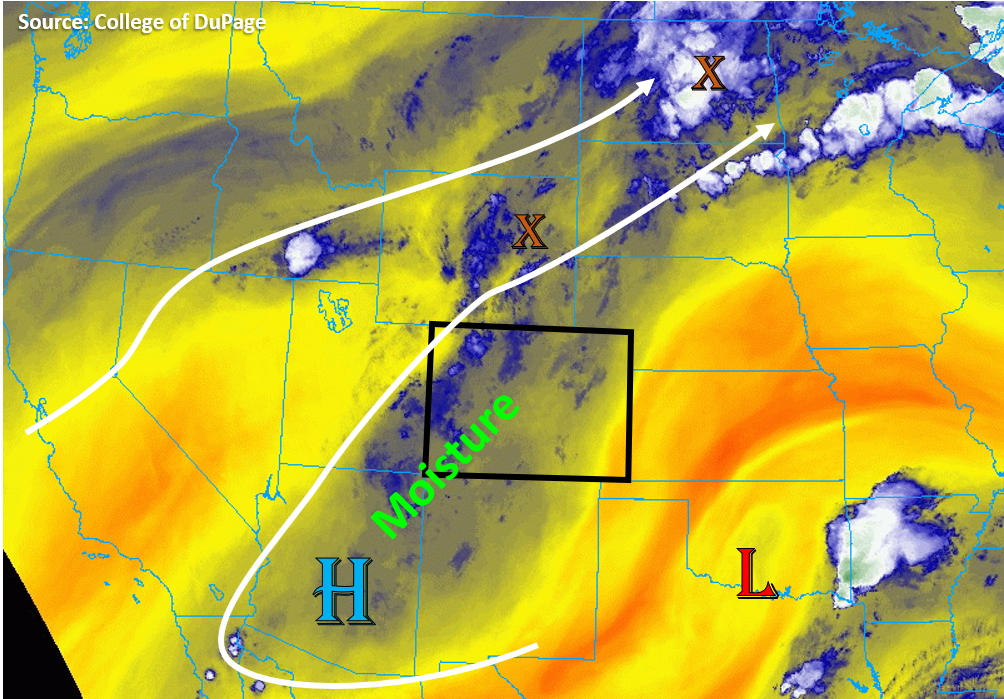
Moisture continues to increase under an elongated High pressure system that is sitting over Colorado today, which will further increase chances for thunderstorms and wetting rainfall over the high terrains. This plume of moisture is best visualized in this morning’s water vapor imagery by the increased blue colors (see image below). Soundings this morning for Denver and Grand Junction show that moisture continues mainly in the mid- and upper-levels with significant dew point depressions near the surface. However, surface moisture looks a little higher today due to the added moisture from precipitation yesterday, so this will mean an increase in rain totals. Increased instability from the extra moisture will allow for some more widespread thunderstorm development. Storms should form over most high terrains by noon, and will continue to have slow storm movements under the high, so this increases the chances for wetting rainfall as storms linger over the peaks for extended periods. Due to the possibility of 1-inch rain totals over a couple hours with increased moisture, a Low flood threat has been issued for most mountain regions. Additional storms may fire along the Palmer Divide with outflow boundaries providing lift to break the weaker cap. With slow storm motion and increased convergence, these storms may also produce some localized flooding issues. Gusty winds are also a possibility with storms today due to the inverted-V profiles.
A couple storms may also be possible over the Northeast Plains and near the Cheyenne Ridge, but with rain rates up to 1 in/hr, flooding is not expected.
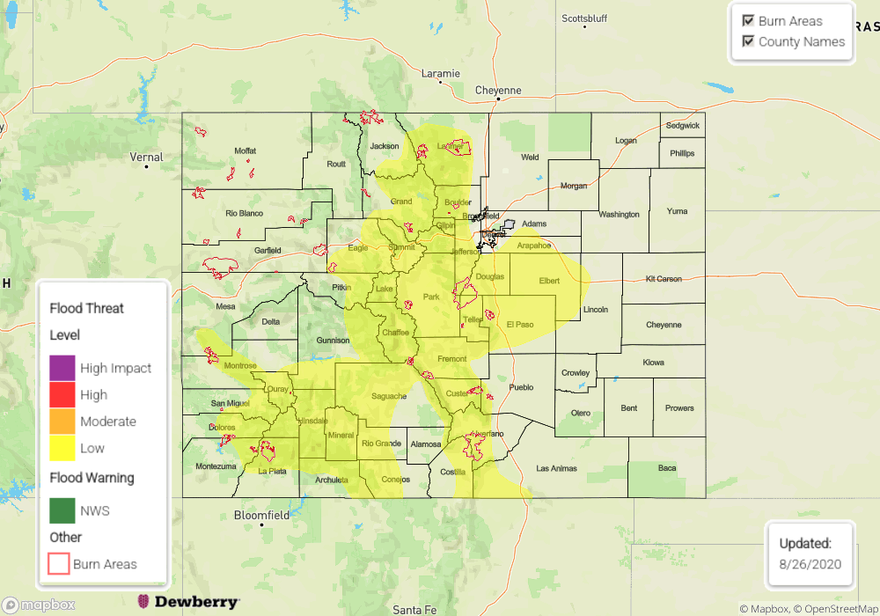
Today’s Flood Threat Map
For more information on today’s flood threat, see the map below. Hover over the threat areas for more details, and click on burn areas to learn more about them. For Zone-Specific forecasts, scroll below the threat map.
Zone-Specific Forecasts:
Grand Valley, Northwest Slope, Northern Mountains, Central Mountains, Southwest Slope, San Juan Mountains, Southeast Mountains, & San Luis Valley:
Storms will fire again over the high terrains this afternoon, which will likely produce some local, heavy downpours (max rain rates up to 0.8 in/hr), gusty winds, and lightning. Due to slow storm motions, several storms could remain over the same area for a couple hours. Although storm cores should remain small, they could lead to rain accumulations up to 1 inch, so a Low flood threat has been issued for the higher elevations of all mountain regions with a couple lingering light showers possible overnight. Of particular concern is flash flooding over steep terrain and burn areas, including the Spring Creek, 416, Decker, and Lake Christine burn areas. Additionally, flash flooding and mud flows over the current Cameron Peak and Williams Fork wildfires are possible with 24-hour rain totals up to 1.5 inches possible near the area. Gusty outflow winds and lightning could worsen the fire danger where little to no rain is able to fall, mainly over the Northwest Slope and Grand Valley.
Dry air moving into the northwest corner of the state should lower rainfall chances there. The lower elevations of the San Luis Valley will likely see more sub-cloud evaporation, but still some significant accumulations are possible (up to 0.8 inch in 2 hours).
Primetime: 12PM to 12AM
Northeast Plains, Urban Corridor, Front Range, Palmer Ridge, Raton Ridge, & Southeast Plains:
It will be above average temperatures again today, with a moderate chance for storms over the Palmer Ridge, Urban Corridor, Front Range, and Northeast Plains. Storms will form over the Front Range by noon and could produce 1 inch of rain over a couple hours, so a Low threat has been issued. Most storms moving off the Front Range into the northern Urban Corridor will dissipate, but storms could drop heavier rain along the southern Urban Corridor. A couple stronger storms could develop over the Palmer Ridge and Northeast Plains with rain rates up to 1 in/hr, so the Low threat has been extended to the western Palmer Ridge. Gusty outflow winds are also possible from storms today due to the lower surface moisture.
Primetime: 12PM to 12AM