Issue Date: Thursday, August 27th, 2020
Issue Time: 8:45AM MDT
— Flooding is NOT expected today
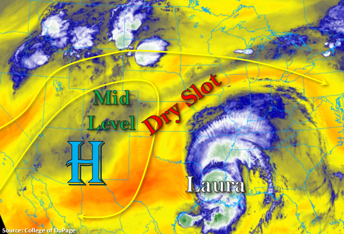
A lot going on in the water vapor imagery below. To our north, there’s a bit of a dirty ridge pattern with some ongoing convection over the northern Rockies and Dakotas associated with an incoming trough. To our southeast, Hurricane Laura made landfall overnight (1AM) and produced 150 mph winds! Those winds have died down to about 120 mph this morning and are forecast to drop to about 75 mph by midday, so life threatening storm surge is occurring along with heavy rainfall. There’s also a really nice dry slot over the Midwest between the two systems. Over Colorado, the elongated High is expected to continue to influence our weather today. Therefore, expecting another round of showers over the mountains and elevated terrains in western Colorado.
The morning soundings at Denver and Grand Junction show most of the moisture below (blue shades) in the mid-levels with it being quite dry at the surface and upper levels. This should reduce rain rates, intensity, and coverage of storms today when compared to yesterday. Not seeing any well-defined shortwave either, so convection should be more pop-like over the high terrains meaning shorter duration and small rainfall cores. As storms move off the eastern mountains with the northwest steering flows, convection is expected to weaken. So, outside of some scattered, weak storms over the elevated ridges, it should remain mostly dry over the lower elevations. Flooding is not expected today.
Today’s Flood Threat Map
For more information on today’s flood threat, see the map below. If there is a threat, hover over the threat areas for more details, and click on burn areas to learn more about them. For Zone-Specific forecasts, scroll below the threat map.

Zone-Specific Forecasts:
Northern Mountains, Central Mountains, San Juan Mountains, Southeast Mountains, Front Range, Grand Valley, Southwest Slope, & Northwest Slope:
Another round of diurnally driven scattered storms are forecast over the mountains and elevated western terrains this afternoon. Decreasing intensity, coverage, and small, short-lived storm cores should put the fresh burn areas at less risk for flash flooding. As always, if a storm tracks overhead, use caution and follow NWS for all of the latest flash flood warnings. The Spring Creek burn area has received quite a bit of beneficial rain the last couple of days (just over a half inch). If a storm tracks over the southern end of the burn area, please use extra caution as this area has proven to be the most susceptible to mud/debris flows. Confidence is not very high that a storm will form over the scar or last long enough/produce enough rain to hit our thresholds for flooding, so no flood threat has been issued. Just wanted to mention the antecedent soil conditions for awareness.
As far as rain totals go, over the eastern mountains, isolated rain totals up to 0.50 inches will be possible with most storms producing between 0.10 and 0.25 inches. The higher totals will be more likely further south. Over western Colorado, isolated totals up to 0.50 inches (south) and 0.25 inches (north) will be possible. Highest totals are expected over the southern/eastern San Juan Mountains again, and all storms today will be capable of producing brief windy conditions (~35 mph gusts). Flooding is not forecast, and a couple weak showers could linger over the high terrains overnight.
Primetime: 12:30PM to 11PM
Palmer Ridge, Raton Ridge, Urban Corridor, Southeast Plains, San Luis Valley, & Northeast Plains:
These regions should remain mostly dry today with little to no rainfall expected for the SLV. Expect storms to weak as they move off the eastern mountains later this afternoon, but some light rainfall will be possible along the I-25 corridor before they dissipate. As the storms weaken, expect some brief windy conditions. Over the elevated ridges, isolated totals up to 0.20 inches will be possible with most storms producing lower to trace amounts of rainfall. As far as high temperatures, expect another day with upper 90Fs along the I-25 corridor and slightly higher temperatures east. The heat wave continues, but there’s a change coming early next week.
Primetime: 3PM to 10PM