Issue Date: Friday, August 28th, 2020
Issue Time: 9:15AM MDT
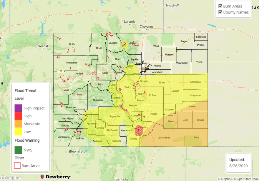
— A HIGH flood threat has been issued for the Spring Creek burn area
— A MODERATE flood threat has been issued for the Raton Ridge, Southeast Plains, and Decker burn area
— A LOW flood threat has been issued for the Front Range, Southeast Mountains, San Juan Mountains, Palmer Ridge, southern Northeast Plain, Urban Corridor, & Cameron Peak burn area
Quite a bit of cloud cover over the state to start this morning and perhaps some weak showers over the southwest corner of the state. The High is being pushed south by a passing trough, which is also dropping a cold front through eastern Colorado this morning. Along the front, gusts around 35 mph are being reported, and it should bring cooler high temperatures to eastern CO this afternoon. Moisture is also increasing behind the northerly flow over eastern Colorado, but it looks fairly shallow in the Denver sounding this morning. Therefore, as the day goes on, expecting the surface moisture further north to mix out with more westerly flow aloft (drying), which will limit the flood threat over this area. For the most part, the majority of the rainfall is expected to occur south of I-70. Due to rain rates up to 0.25 inches/hour still possible over the northern Front Range, a Low flood threat has been issued for the Cameron Peak burn area due to high probability of storms forming near the area with extra upper level lift.
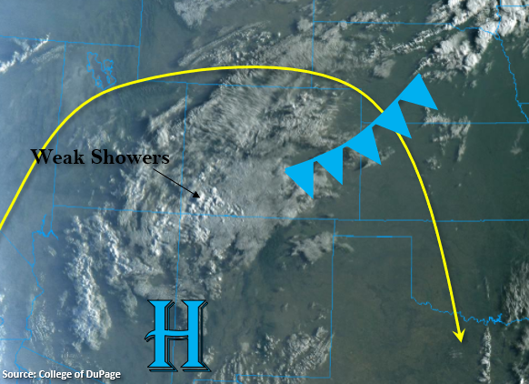
The shortwave energy producing the lift for the cloud cover/weak showers over the southwest corner will start to move to the northeast, and with a little daytime heating and increased moisture, expecting an uptick in intensity and coverage of storms. This is especially true over the southern mountains and immediate adjacent plains where higher moisture will help increase rainfall coverage and rain rates. While rain totals won’t be quite as high over the San Juan Mountains (less surface moisture), training storm could produce some higher totals over the southern and eastern San Juan Mountains, so it has been included in the Low threat.
Recent burn areas over the Southeast Mountains will also be more susceptible to flash flood today, especially the Spring Creek burn area since it has received a couple round of rain the last couple of days. With rain totals up between 0.75 inches (north) and 1 inch (south) possible, a High flood threat has been issued for the Spring Creek burn area, and a Moderate flood threat has been issued for the Decker burn area. Over the Raton Ridge, extra convergence from the elevation and front will produce widespread, heavy rainfall, thus the Moderate flood threat for this area. Overnight rainfall is expected for the Southeast Plains. Should moisture be able to hang on a bit further north, some heavy rainfall will also be possible over the Palmer Ridge and east, so the Low threat extends to the north.
Today’s Flood Threat Map
For more information on today’s flood threat, see the map below. If there is a threat, hover over the threat areas for more details, and click on burn areas to learn more about them. For Zone-Specific forecasts, scroll below the threat map.
Zone-Specific Forecasts:
Southeast Mountains, Front Range, & San Juan Mountains:
Multiple rounds of rainfall are expected over the mountains this afternoon. Isolated totals up to 1 inch will be possible over the southern/eastern San Juan Mountains, while over the southern Front Range and Southeast Mountains, more widespread totals of 1 inch will be possible. In addition to heavy rainfall, storms could produce small hail and strong outflow winds. The heavy rainfall potential will put burn areas under an elevated flood threat this afternoon, so a High flood threat has been issued for the Spring Creek burn area and a Moderate flood threat for the Decker burn area. Further north, rain rates should decrease, but max 1-hour rain rates up to 0.25 inches will still be possible. So, if storms form over the fresh Cameron Creek burn area, flash flooding could be an issue. Thus, the Low flood threat. If storms form over-top of a burn area, flash flooding, mud flows, and debris slides are all possible.
Primetime: 12PM to 10PM
Palmer Ridge, Raton Ridge, Urban Corridor, Southeast Plains, San Luis Valley, & Northeast Plains:
Heavy rainfall will be likely south of I-70 this afternoon, so a Low and Moderate flood threat have been issued. The best chance for widespread rainfall will be south over the Raton Ridge and Southeast Plains. Max 1-hour rain rates up to 2 inches are expected over the area with widespread totals over 1 inch. Further north, totals up to 1.5 inches (east) and 1.25 inches (west) will be possible, thus the Low flood threat. A couple severe storms may be possible as well (south) with the threats being large hail and then wind as upscale growth occurs. The main flood threats from the heavy downpours this evening will be arroyo flooding, local creek flooding, road flooding, and field ponding. The SLV is also expected to get some rain with isolated totals up to 0.30 inches possible in the interior of the valley.
Primetime: 3:30PM to 4AM
Northern Mountains, Central Mountains, Grand Valley, Southwest Slope, & Northwest Slope:
Increased storm chances today when compared to yesterday, but the scattered storms should mostly stick to the high terrains. With less moisture at the surface (Continental Divide acting as a barrier), rain rates should be lower with some gusty outflow winds possible. Further north, max 1-hour rain rates should stay under 0.15 inches for the most part, but over the Central Mountains near the Divide, totals up to 0.40 inches will be possible. Prolonged rainfall is not expected over any area, so no flood threats have been issued for recent burn areas. As always, use caution if a storm tracks overhead. A second wave of rain is expected to arrive at midnight, which may bring some light rain to the lower elevations of the Grand Valley and Southwest Slope.
Primetime: 11AM to ongoing