FTB 09-02-2020: Dry and Warmer

Issue Date: Wednesday, September 2nd, 2020
Issue Time: 09:15AM MDT

— Flooding is NOT expected today

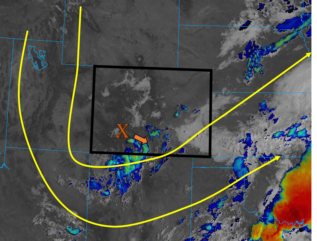
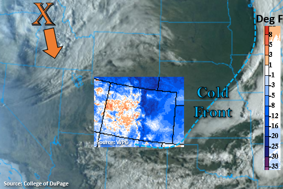
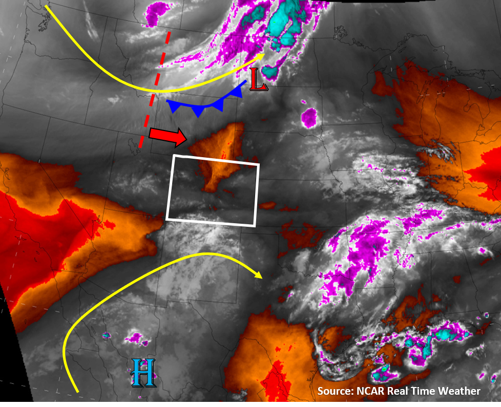
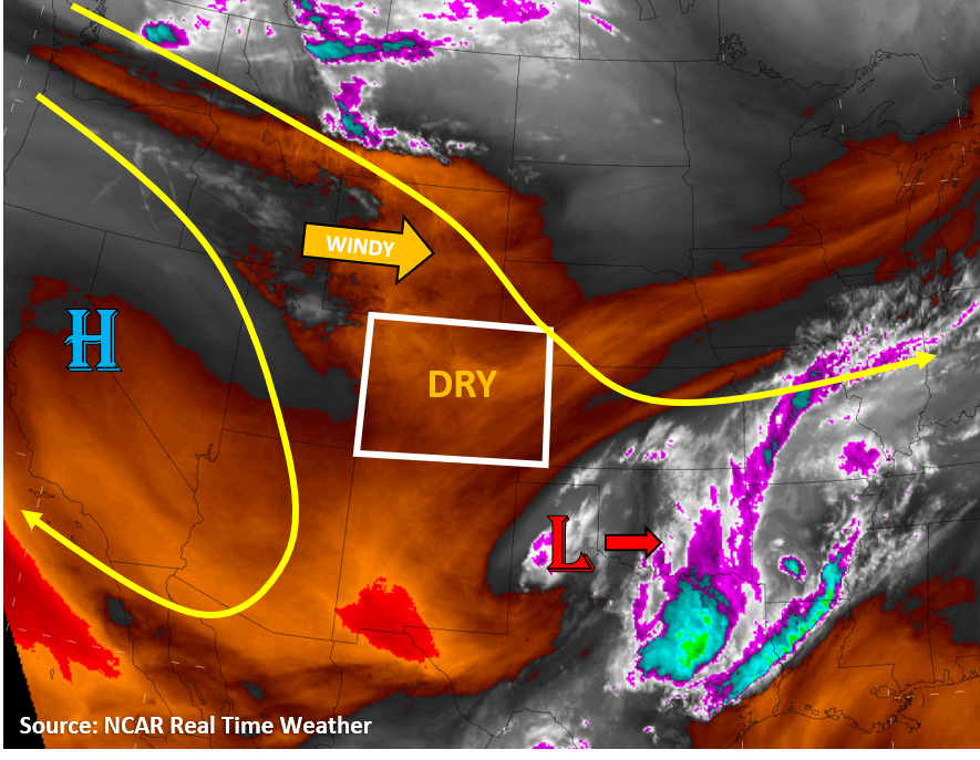
Dry, sinking air is in place over Colorado today as the low pressure system that moved through Colorado the last 36 hours has moved southeast into the southern US Plains (see image below). This dry air aloft, indicated by the orange colors on the water vapor satellite image below, will mix in with already low surface moisture across the state (dew points in the 30Fs and 40Fs) to create almost no chance of rainfall. Additionally, sinking air motions have set up a strong cap over Colorado, which is visible in this morning’s soundings. This cap will further prevent any convection from firing and promote clear skies statewide. A strong polar jet stream and large-scale trough to our north will increase winds over Wyoming and Montana, but some gusty winds could work their way into far northern Colorado. These stronger winds, along with dry air, will increase fire danger along the northern tier of Colorado. Temperatures will increase today when compared to yesterday, with high temperatures near or slightly above average across the state. Late tonight and into tomorrow morning, a cold front will work its way through the plains of eastern Colorado. No precipitation is expected along the front, due to its nocturnal arrival and limited moisture, but some strong gusts (up to 55 mph) will be possible over the eastern plains. No flooding is expected in Colorado today.

Today’s Flood Threat Map

For more information on today’s flood threat, see the map below. Hover over the threat areas for more details, and click on burn areas to learn more about them. For Zone-Specific forecasts, scroll below the threat map.

Zone-Specific Forecasts:

Northeast Plains, Urban Corridor, Front Range, Palmer Ridge, Raton Ridge, Southeast Mountains, & Southeast Plains:

The weather should be quite pleasant today with plenty of sunshine and temperatures near to slightly above average in the mid to upper 80Fs. Other than a few fair weather cumulus over the high terrains and Southeast Plains, it should be a clear day. No precipitation is expected due to a strong cap and plenty of dry air. Enjoy the nearly smoke-free, clear air and views of the mountains once again.

Grand Valley, Northwest Slope, Northern Mountains, Central Mountains, Southwest Slope, San Juan Mountains, & San Luis Valley:

Mostly sunny and near average high temperatures today. A few cumulus may develop over the high terrains with diurnal heating and upslope mountain flows, but no precipitation is expected. Some gusty winds near the Colorado/Wyoming border will increase the fire danger slightly this afternoon, so be cautious and avoid activities that could cause sparks.

FTB 09-01-2020: Scattered Storms for Southeast Mountains as the Shortwave Departs Colorado

Issue Date: Tuesday, September 1st, 2020
Issue Time: 10:05AM MDT

— Flooding is NOT expected today

A strong shortwave that moved into Colorado late yesterday and produced overnight mountain rainfall and light snow will continue to move southeast and exit the state along its southern border. This upper Low is creating some clouds and light showers over the southern San Juan Mountains and Southeast Mountains this morning (blue/green on satellite image below), and will be the focus of any precipitation that forms today. Leftover surface moisture remains over the state this morning with dew points in the 30Fs and 40Fs over the mountains and 50Fs over the plains. The highest moisture is over the Southeast Plains where low-level clouds are present this morning (white on satellite image below).

This morning’s Grand Junction sounding shows that there is drier air aloft behind this Low. This drier air, paired with sinking motion, will keep precipitation chances low for much of the state today. The best chances for precipitation will be over the southern San Juan and Southeast Mountains as the shortwave energy moves over the area. A surface low pressure is expected to develop over the Oklahoma panhandle, which will allow some moisture to remain pushed up against the Southeast Mountains and Southeast Plains. This moisture, along with daytime heating, will allow some additional storms to fire over the far southern portions of the San Juan and Southeast Mountains later this afternoon and evening. The strongest cells further south could produce brief, heavy downpours if some instability can build, but flooding is not expected today due to the small coverage of the stronger storms. The southern end of the Spring Creek burn area will be close to these convective cells, but with limited instability further north, increased lift further south (Raton Ridge) has a higher likelihood for the heavier rain rates (0.75 in/hr).

Today’s Flood Threat Map

For more information on today’s flood threat, see the map below. Hover over the threat areas for more details, and click on burn areas to learn more about them. For Zone-Specific forecasts, scroll below the threat map.

Zone-Specific Forecasts:

Raton Ridge, Southeast Mountains, San Juan Mountains, Southeast Plains, & San Luis Valley:

Convective showers and some isolated storms will likely fire this afternoon over the high terrains of the San Juan and Southeast Mountains. The strongest of these storms could produce isolated rain rates up to 0.75 in/hr over the southern portion of the Southeast Mountains near the Raton Ridge. Drier air and a less favorable location behind the departing shortwave will keep rain rates lower over the southern San Juan Mountains (up to 0.4 in/hr). No flooding is expected over the mountain regions as storms should stay closer to the CO/NM border and away from the more vulnerable Spring Creek burn area. As always, if a storm does track over the burn area, flash flooding, mud flows, and debris slides could occur.

Low-level clouds this morning should help reinforce a cap over the Southeast Plains and prevent large amounts of instability from building. However, there is a slight chance that storms could fire over the border counties, but not seeing any well-defined feature to help break the cap at this moment. If storms do fire, they could produce isolated areas with rain rates up to 1 in/hr. No flooding is expected with these storms, and they should move southeast out of the state with the departing shortwave.

Primetime: 12PM to 8PM

Grand Valley, Northwest Slope, Northern Mountains, Central Mountains, Southwest Slope, Northeast Plains, Urban Corridor, Front Range, & Palmer Ridge:

Today should be mainly sunny for most regions, with high temperatures around 5F below normal. However, temperatures have cooled down about 8F to 15F from yesterday at this time. Drier air will be mixing its way down to the surface as the fall-like shortwave system moves out of Colorado, which will limit rainfall chances. Clouds should form over the high terrains this afternoon, but the only chance for measurable rainfall will be over the southern Central Mountains and Front Range. Rain totals should stay under 0.10 inches, so no flooding is expected today. Enjoy the cool down because it’s about to heat back up again this week.

FTB 08-31-2020: First Fall-Like Cool Down

Issue Date: Monday, August 31st, 2020
Issue Time: 9:15AM MDT

— Flooding is NOT expected today

Finally, a change in the pattern, and it is great timing as meteorological fall begins tomorrow. This morning, Colorado is sitting between two systems, which can be seen in the visible satellite imagery below. The first is just south, which passed a strong cold front through the state. The 24-hour difference in temperature (6AM) is shown below with the legend on the right-hand side (deg F), so it’s a cool start to the morning for eastern and northwest Colorado. The second system is a strong upper-level trough, which will start to push south today (orange “X”). This will bring some cooler temperatures to western Colorado later tonight as well as some overnight rainfall to the mountains.

Northerly surface flow behind the front is forecast to turn southwesterly today over the eastern plains, and the diurnal flow will help produce the first round of scattered showers by early afternoon over the Palmer Ridge, Southeast Mountains, and Raton Ridge. Quick, easterly steering flow should move the storms into the adjacent plains with only light to moderate rainfall forecast due to CAPE and surface moisture values on the lower end. As the shortwave arrives from the north this evening, increasing cloud cover with the system and decreasing instability will limit the convection potential over the northern half of the state. However, there’s a good chance it will still trigger some thunderstorms over the Northeast Plains this evening where there will be better surface heating. Otherwise, the system is expected to produce some beneficial, stratiform rainfall over the mountains tonight as it keeps pushing south. Rainfall should be gradual enough that flooding issues should be avoided, so flooding is not expected.

Today’s Flood Threat Map

For more information on today’s flood threat, see the map below. If there is a threat, hover over the threat areas for more details, and click on burn areas to learn more about them. For Zone-Specific forecasts, scroll below the threat map.

Zone-Specific Forecasts:

Palmer Ridge, Raton Ridge, Southeast Mountains, Front Range, Urban Corridor, Southeast Plains, San Luis Valley, & Northeast Plains:

Cool start to the morning means that there will be a break in the hot, afternoon temperatures. Highs are forecast to be 10-15F cooler than yesterday, and increasing southeasterly surface winds will make it feel even cooler. First set of storms will form south with evening storms forecast for the Northeast Plains. Max 1-hour rain rates up to 0.30 inches (mountains), 0.35 inches (adjacent plains), and 0.75 inches (eastern plains) will be possible. Storms will also be capable of producing some brief, gusty outflow winds this afternoon. Some rainfall late tonight into tomorrow morning will also be possible over the mountains associated with the upper trough. Due to the gradual nature of the rainfall overnight and the fast-moving storms this afternoon, flooding is not forecast. There is a chance for a dusting of snow over the highest elevations tonight.

Primetime: 1:30PM to ongoing

Northern Mountains, Central Mountains, San Juan Mountains, Grand Valley, Southwest Slope, & Northwest Slope:

Not much rainfall action until the shortwave arrives tonight. With warm temperatures forecast this afternoon, increasing surface winds (15 to 25 mph; gusts 30 to 40 mph), and low relative humidity, a Red Flag Warning has been issued from 1PM to 9PM over the Northwest Slope and Grand Valley. The upper level jet, associated with the shortwave, should help generate some showers from this evening into tomorrow morning over western Colorado. Most of the measurable rainfall is expected to be over the mountains with light snow likely over the highest peaks. Isolated totals up to 0.25 inches are possible by morning. Due to the gradual nature of the rainfall, flooding is not forecast. Expect some cooler temperatures by tomorrow morning as well.

Primetime: 8PM to ongoing

FTB 08-30-2020: Gusty Winds and Isolated Storms

Issue Date: Sunday, August 30th, 2020
Issue Time: 09:30AM MDT

— Flooding is NOT expected today

A large trough will be passing over northern Colorado today, which will increase winds, especially over the northern half of Colorado. Some drier air will also mix out surface moisture, which will limit precipitation for most of the state. This drier air can be seen on the water vapor satellite imagery below as the orange and red colors over northern Colorado. This morning’s soundings show PW has decreased when compared to yesterday (0.60″ in Denver, 0.77″ in Grand Junction). Storms will still likely fire over the high terrains with diurnal heating, but they will quickly move east/southeast in the stronger west/northwest flow today. The best chances for seeing storms is over the San Juan Mountains, as a pocket of higher moisture will hold on there due to southwesterly monsoon flow impinging on the southern tip of Colorado (gray/white colors on image below). However, limited moisture and fast storm motions today means flooding is not expected across the state.

A cold front will move into eastern Colorado later this evening, but due to low moisture, this should be a dry front. Little to no precipitation is expected with its passing. Currently this cold front is over northern Wyoming (see image below).

Stronger winds and drier air today along the northern tier of Colorado will increase the fire danger today. A Red Flag Warning has been issued by NWS for portions of the Northwest Slope and Northeast Plains because of this. Stronger winds could also help the current wild fires burning across Colorado to grow, unfortunately.

Today’s Flood Threat Map

For more information on today’s flood threat, see the map below. Hover over the threat areas for more details, and click on burn areas to learn more about them. For Zone-Specific forecasts, scroll below the threat map.

Zone-Specific Forecasts:

Grand Valley, Northwest Slope, Northern Mountains, Central Mountains, Southwest Slope, San Juan Mountains, & San Luis Valley:

Clouds and isolated storms will develop over the high terrains around noon today with plenty of daytime heating. The best chances for storms will be over the San Juan Mountains, where rain rates up to 0.5 in/hr are possible. However, strong upper-level winds (20-30 mph) will push storms off to the east/southeast fairly quickly, so flooding is not expected today.

Gusty winds will make their way down to the surface over the northern half of the state, which will increase the fire danger with drier air in place today. Isolated storms could also produce gusty outflow winds up to 60 mph. Be cautious not to cause sparks today, and don’t forget there is currently a fire ban in place across the state (campfires included).

Primetime: 12PM to 8PM

Northeast Plains, Urban Corridor, Front Range, Palmer Ridge, Raton Ridge, Southeast Mountains, & Southeast Plains:

Partly cloudy and warmer today with isolated showers or weak thunderstorms not out of the question during the afternoon and evening. Isolated storms will form over the high terrains of the southern Front Range and Southeast Mountains around noon. Lower chances for storms farther north due to less moisture. These isolated storms will quickly move east into the plains regions due to stronger flow aloft, and additional storms could fire over the Palmer Ridge. However, rain rates with any storms that fire should remain below 0.3 in/hr, so no flooding is expected. Gusty winds are likely along the northern Urban Corridor, Northeast Plains, and Front Range (downslope winds), and storm outflow could add wind gusts up to 60 mph.

Primetime: 12PM to 8PM