Issue Date: Monday, August 31st, 2020
Issue Time: 9:15AM MDT
— Flooding is NOT expected today
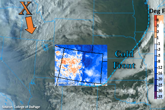
Finally, a change in the pattern, and it is great timing as meteorological fall begins tomorrow. This morning, Colorado is sitting between two systems, which can be seen in the visible satellite imagery below. The first is just south, which passed a strong cold front through the state. The 24-hour difference in temperature (6AM) is shown below with the legend on the right-hand side (deg F), so it’s a cool start to the morning for eastern and northwest Colorado. The second system is a strong upper-level trough, which will start to push south today (orange “X”). This will bring some cooler temperatures to western Colorado later tonight as well as some overnight rainfall to the mountains.
Northerly surface flow behind the front is forecast to turn southwesterly today over the eastern plains, and the diurnal flow will help produce the first round of scattered showers by early afternoon over the Palmer Ridge, Southeast Mountains, and Raton Ridge. Quick, easterly steering flow should move the storms into the adjacent plains with only light to moderate rainfall forecast due to CAPE and surface moisture values on the lower end. As the shortwave arrives from the north this evening, increasing cloud cover with the system and decreasing instability will limit the convection potential over the northern half of the state. However, there’s a good chance it will still trigger some thunderstorms over the Northeast Plains this evening where there will be better surface heating. Otherwise, the system is expected to produce some beneficial, stratiform rainfall over the mountains tonight as it keeps pushing south. Rainfall should be gradual enough that flooding issues should be avoided, so flooding is not expected.
Today’s Flood Threat Map
For more information on today’s flood threat, see the map below. If there is a threat, hover over the threat areas for more details, and click on burn areas to learn more about them. For Zone-Specific forecasts, scroll below the threat map.

Zone-Specific Forecasts:
Palmer Ridge, Raton Ridge, Southeast Mountains, Front Range, Urban Corridor, Southeast Plains, San Luis Valley, & Northeast Plains:
Cool start to the morning means that there will be a break in the hot, afternoon temperatures. Highs are forecast to be 10-15F cooler than yesterday, and increasing southeasterly surface winds will make it feel even cooler. First set of storms will form south with evening storms forecast for the Northeast Plains. Max 1-hour rain rates up to 0.30 inches (mountains), 0.35 inches (adjacent plains), and 0.75 inches (eastern plains) will be possible. Storms will also be capable of producing some brief, gusty outflow winds this afternoon. Some rainfall late tonight into tomorrow morning will also be possible over the mountains associated with the upper trough. Due to the gradual nature of the rainfall overnight and the fast-moving storms this afternoon, flooding is not forecast. There is a chance for a dusting of snow over the highest elevations tonight.
Primetime: 1:30PM to ongoing
Northern Mountains, Central Mountains, San Juan Mountains, Grand Valley, Southwest Slope, & Northwest Slope:
Not much rainfall action until the shortwave arrives tonight. With warm temperatures forecast this afternoon, increasing surface winds (15 to 25 mph; gusts 30 to 40 mph), and low relative humidity, a Red Flag Warning has been issued from 1PM to 9PM over the Northwest Slope and Grand Valley. The upper level jet, associated with the shortwave, should help generate some showers from this evening into tomorrow morning over western Colorado. Most of the measurable rainfall is expected to be over the mountains with light snow likely over the highest peaks. Isolated totals up to 0.25 inches are possible by morning. Due to the gradual nature of the rainfall, flooding is not forecast. Expect some cooler temperatures by tomorrow morning as well.
Primetime: 8PM to ongoing