Issue Date: Sunday, August 30th, 2020
Issue Time: 09:30AM MDT
— Flooding is NOT expected today
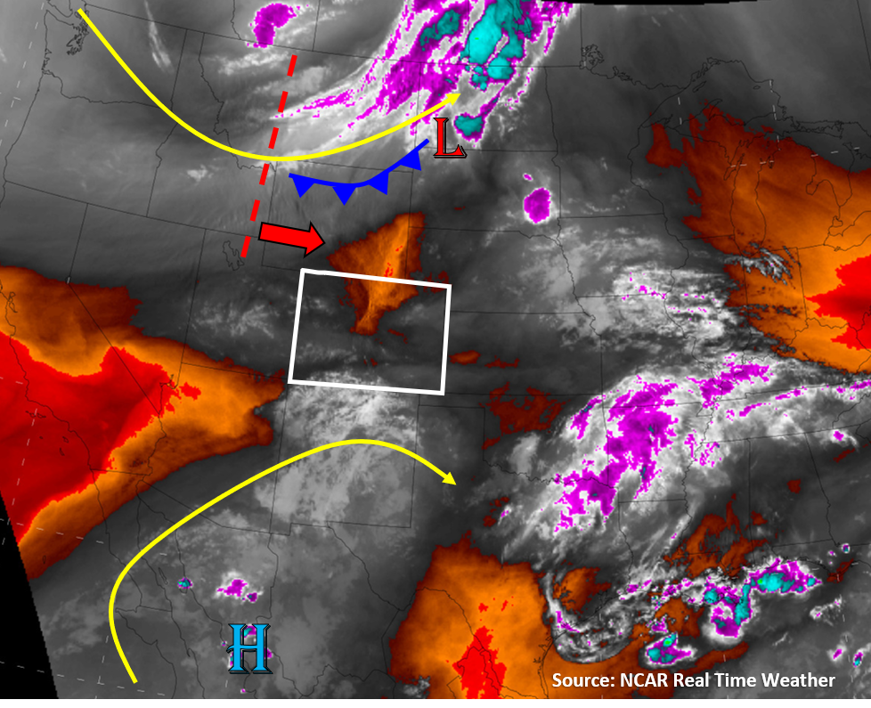
A large trough will be passing over northern Colorado today, which will increase winds, especially over the northern half of Colorado. Some drier air will also mix out surface moisture, which will limit precipitation for most of the state. This drier air can be seen on the water vapor satellite imagery below as the orange and red colors over northern Colorado. This morning’s soundings show PW has decreased when compared to yesterday (0.60″ in Denver, 0.77″ in Grand Junction). Storms will still likely fire over the high terrains with diurnal heating, but they will quickly move east/southeast in the stronger west/northwest flow today. The best chances for seeing storms is over the San Juan Mountains, as a pocket of higher moisture will hold on there due to southwesterly monsoon flow impinging on the southern tip of Colorado (gray/white colors on image below). However, limited moisture and fast storm motions today means flooding is not expected across the state.
A cold front will move into eastern Colorado later this evening, but due to low moisture, this should be a dry front. Little to no precipitation is expected with its passing. Currently this cold front is over northern Wyoming (see image below).
Stronger winds and drier air today along the northern tier of Colorado will increase the fire danger today. A Red Flag Warning has been issued by NWS for portions of the Northwest Slope and Northeast Plains because of this. Stronger winds could also help the current wild fires burning across Colorado to grow, unfortunately.
Today’s Flood Threat Map
For more information on today’s flood threat, see the map below. Hover over the threat areas for more details, and click on burn areas to learn more about them. For Zone-Specific forecasts, scroll below the threat map.

Zone-Specific Forecasts:
Grand Valley, Northwest Slope, Northern Mountains, Central Mountains, Southwest Slope, San Juan Mountains, & San Luis Valley:
Clouds and isolated storms will develop over the high terrains around noon today with plenty of daytime heating. The best chances for storms will be over the San Juan Mountains, where rain rates up to 0.5 in/hr are possible. However, strong upper-level winds (20-30 mph) will push storms off to the east/southeast fairly quickly, so flooding is not expected today.
Gusty winds will make their way down to the surface over the northern half of the state, which will increase the fire danger with drier air in place today. Isolated storms could also produce gusty outflow winds up to 60 mph. Be cautious not to cause sparks today, and don’t forget there is currently a fire ban in place across the state (campfires included).
Primetime: 12PM to 8PM
Northeast Plains, Urban Corridor, Front Range, Palmer Ridge, Raton Ridge, Southeast Mountains, & Southeast Plains:
Partly cloudy and warmer today with isolated showers or weak thunderstorms not out of the question during the afternoon and evening. Isolated storms will form over the high terrains of the southern Front Range and Southeast Mountains around noon. Lower chances for storms farther north due to less moisture. These isolated storms will quickly move east into the plains regions due to stronger flow aloft, and additional storms could fire over the Palmer Ridge. However, rain rates with any storms that fire should remain below 0.3 in/hr, so no flooding is expected. Gusty winds are likely along the northern Urban Corridor, Northeast Plains, and Front Range (downslope winds), and storm outflow could add wind gusts up to 60 mph.
Primetime: 12PM to 8PM