FTB 09-02-2022: Precipitation Chances Increase East, Although More Of A Wind Than Heavy Rainfall Threat

Issue Date: Friday, September 2nd, 2022
Issue Time: 9:05AM MDT

— Flooding is NOT expected today

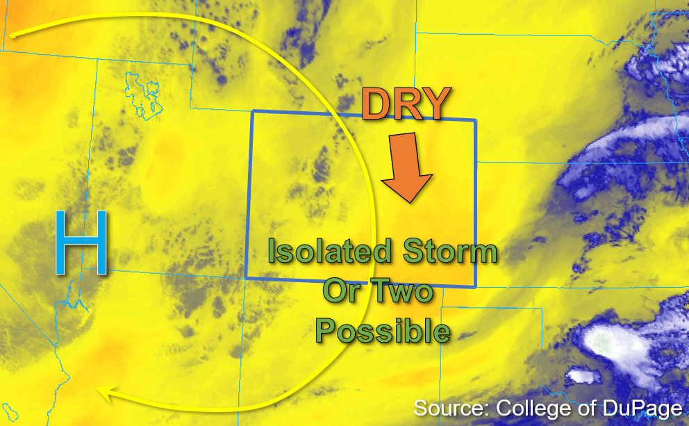
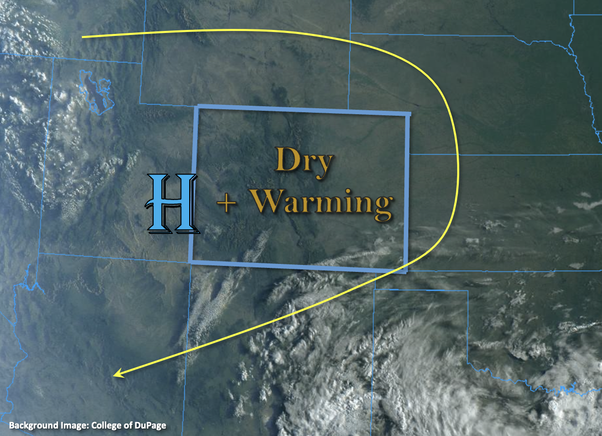
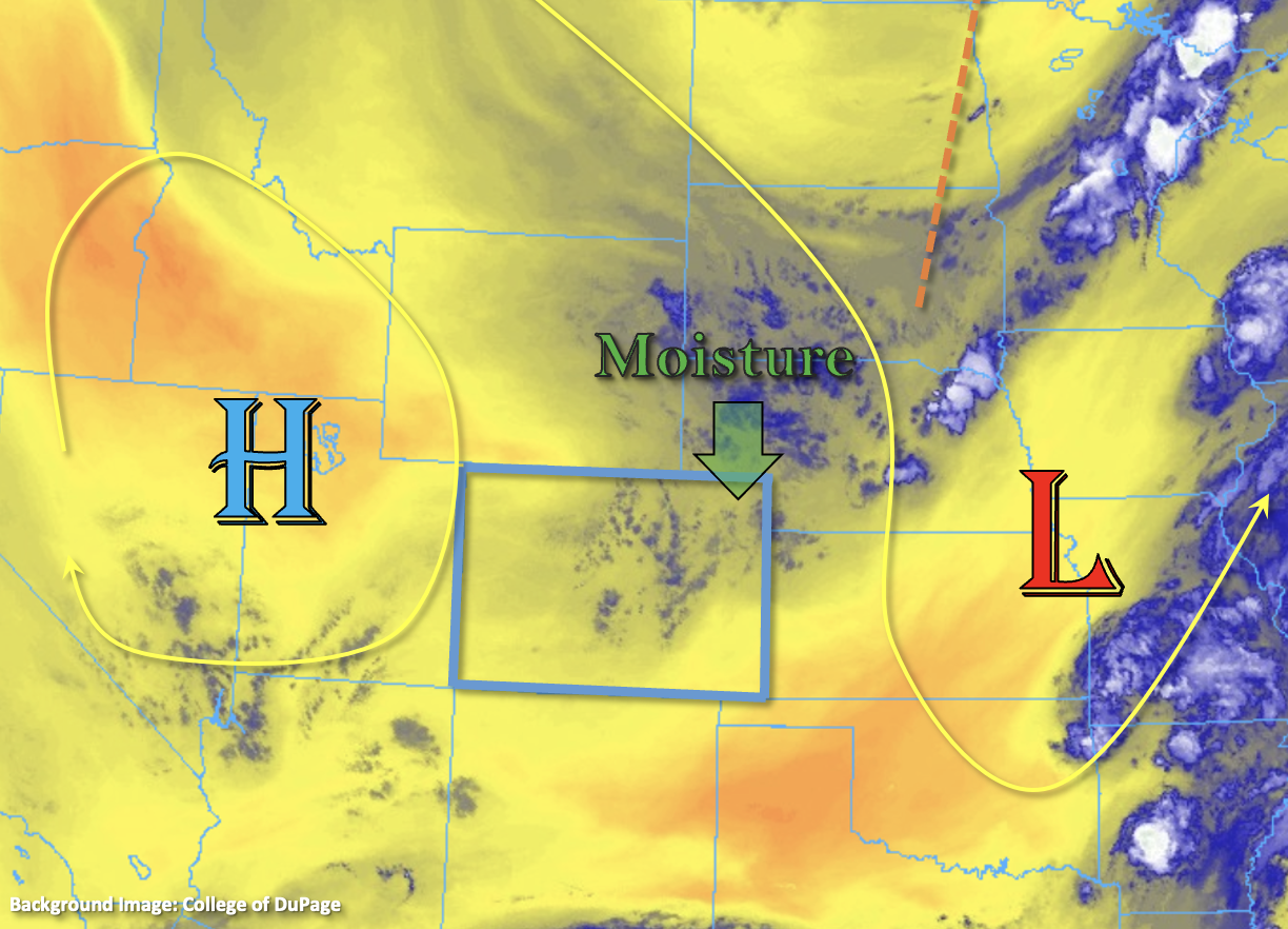
There will be a minor change to the synoptic pattern today, which will help to increase the chance for precipitation over eastern Colorado. A passing trough to our north is forecast to drop a weak cold front south and through the plains later today, which will help pull in some slightly higher moisture values over the area as indicated by the blue shades in the water vapor imagery below. In addition to the surface boundary, upper dynamics and enhanced convergence over the Palmer Ridge should help produce a little extra vertical motion causing an uptick in precipitation coverage over the plains. PW at Platteville was measured at 0.53 inches this morning, which should increase slightly throughout the day. However, a drier boundary layer and moderate steering flows should limit the flood threat as the isolated storms move south. In addition to storms that develop along the front through this evening, there could be increased upslope flow over the Front Range later this afternoon and evening. Again, limited surface moisture indicate that the isolated storms will be more likely to produce light to moderate rainfall, plenty of virga and perhaps some brief outflow winds, so flooding is NOT expected.

Over western Colorado, PW at Grand Junction was measured below average at 0.54 inches, and with continued subsidence from the High, most of the region should remain dry again today. With slightly higher moisture estimated over the San Juan Mountains, and to a lesser extent the Southeast Mountains, a couple isolated high-based storms may develop again this afternoon with the diurnal flow. Slower SSW storm movement should keep the rainfall confined to the high terrain, and flooding is NOT expected.

Today’s Flood Threat Map

For more information on today’s flood threat, see the map below. If there is a threat, hover over the threat areas for more details, and click on burn areas to learn more about them. For Zone-Specific forecasts, scroll below the threat map.

Zone-Specific Forecasts:

Front Range, Raton Ridge, Urban Corridor, Palmer Ridge, Northeast Plains & Southeast Plains:

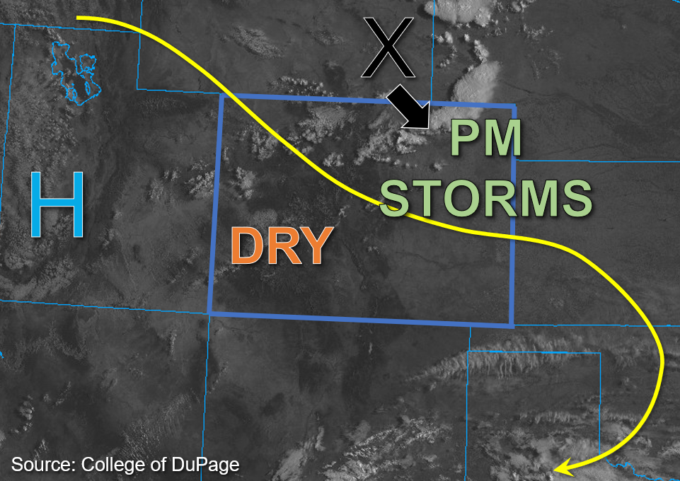
There will be two areas of potential rainfall development this afternoon through this evening. One will be over the adjacent plains along the front, and the other will be over the mountains/immediate adjacent plains associated with the diurnal flow. Both areas are expected to have limited surface moisture, which mean the isolated storms are likely to produce lots of virga, brief outflow gusts and only light to moderate rainfall. Over the plains, max 30 to 45-minute rainfall rates up to 0.5 inches will be possible along with the better potential for some strong outflow gusts (up to 50 mph). Over the mountains and adjacent plains, max 30 to 45-minute rainfall rates up to 0.25 inches will be possible. Flooding is NOT expected today.

Primetime: 2PM to 11PM 

Southeast Mountains, Central Mountains, Southwest Slope, Northwest Slope, Northern Mountains, Grand Valley & San Juan Mountains & San Luis Valley:

Afternoon temperatures should increase a little today with some fair weather cumulus likely to develop over the high terrain by this afternoon. A couple isolated, light showers may be possible over the high terrain with the best chance of this occurring further south. Storm totals should remain under 0.2 inches with plenty of virga, so flooding is NOT expected.

Primetime: 2PM to 8PM

FTB 09-01-2022: A Dry Start To September With An Isolated Storm Or Two Possible South

Issue Date: Thursday, September 1st, 2022
Issue Time: 10:05 AM MDT

— Flooding is NOT expected today

The upper-level high-pressure system to the west has shifted slightly southward to the southwestern Utah border with southeastern Nevada. This slight shift is going to produce a more northerly steering flow that will continue to advect dry air from Wyoming, as shown in the water vapor image below. PW values of 0.5 and 0.52 inches were measured in Grand Junction and Platteville this morning, respectively, indicating increased drying through the column from yesterday over eastern areas. The most notable change is that surface moisture has decreased significantly from yesterday over the northern and central portions of the state, with dew points in the mid-30s to low 40s°F common in the lower elevations west and upper 20s to low 30s°F dew points in the mountains this morning.

The highest surface moisture remains over far southeastern Colorado where some upper 50s and low 60s°F dew points are in place. That said, significant mixing out of moisture is expected with the dry air intrusion from the north throughout the day. As subsidence continues to build and contribute to warm temperatures aloft, and with negligible instability forecast, storm chances are very low today. An isolated storm cannot be ruled out over the southern high terrain, as well as over the far eastern border counties where marginal moisture and instability may be just sufficient enough to sustain an isolated brief storm or two. However, steering flow up to 25mph should move storms quickly southward out of state and flooding is NOT expected today.

Today’s Flood Threat Map

For more information on today’s flood threat, see the map below. If there is a threat, hover over the threat areas for more details, and click on burn areas to learn more about them. For Zone-Specific forecasts, scroll below the threat map.

Zone-Specific Forecasts: 

Southwest Slope, San Juan Mountains, San Luis Valley, Grand Valley, Central Mountains, Northern Mountains, & Northwest Slope:

Some widely scattered clouds are drifting southward across portions of the Northern and Central Mountains this morning. This afternoon, a few stray cumuli may continue this southward movement across the higher elevations, and a few brief virga showers may be possible. However, given the decreasing surface moisture that is already limited to begin with, no meaningful precipitation is expected, except perhaps over the far southern San Juan Mountains and Southwest Slope. Isolated 30 minute rain rates up to 0.3 inches may be possible over the far southern border counties but flooding is NOT expected today.

Primetime: 2PM to 8PM

Front Range, Urban Corridor, Northeast Plains, Palmer Ridge, Southeast Mountains, Raton Ridge, & Southeast Plains:

Lingering cloud cover from the departing shortwave to the east has dissipated this morning, leaving behind mostly clear skies for eastern Colorado for the remainder of the day. That said, a few isolated storms may develop over the far eastern and southeastern border counties, with a few stray virga showers also possible over the Front Range and Southeast Mountains this afternoon. Given decreasing surface moisture and lacking instability, any showers/storms that do form should be brief and move southward relatively quickly given faster steering flows. Over the far eastern border counties, as well as over the Southeast Mountains, an isolated storm or two may produce 30-minute rain rates up to 0.3 inches. Flooding is NOT expected today.

Primetime: 3PM to 8PM

FTB 08-31-2022: Closing Out August With Scattered Storms East And South

Issue Date: Wednesday, August 31st, 2022
Issue Time: 10:45 AM MDT

— Flooding is NOT expected today

This morning, high pressure centered over the Utah and Nevada border continues to produce northwest flow aloft over Colorado. This drier air and subsidence should help to keep much of western Colorado dry this afternoon. The key change in today’s forecast from prior days is a shortwave trough over southeastern Wyoming, which is marked by the “X” in the visible satellite image below. This disturbance is expected to move southeast into the eastern plains this afternoon and help promote uplift in the area. With an upper-level jet also in the area and a convergence boundary at the surface, there should be sufficient dynamics to trigger isolated to widely scattered afternoon storms across the eastern plains and elevated ridges this afternoon. The best chance for storms is expected to be over the Northeast Plains, Palmer Ridge, and the higher terrain south.

While column moisture is not overly impressive this morning with PW values of 0.53 inches and 0.63 inches measured in Grand Junction and Platteville, respectively, surface moisture across the eastern plains is slightly higher than in prior days with the addition of some moisture from the shortwave. Dew points above 60°F are noted across the far eastern border counties, while dew points are currently in the 50s°F closer to the foothills and over far southwest Colorado. This surface moisture is expected to mix out somewhat today, which means that storms that do develop should have elevated bases with the primary threats being gusty winds. Instability should be fairly marginal across the state this afternoon with values forecast to reach between 800 to 1000 J/kg of CAPE across northeastern Colorado. DCAPE values averaging above 1200 J/kg for eastern Colorado increases confidence that storms are likely to produce strong downdrafts with damaging wind gusts possible. In addition to surface moisture lacking, faster southeast steering flow in the 20mph range means that storms should produce only moderate rainfall. Therefore, NO flooding is expected today for eastern Colorado.

For southwest portions of the state slower steering flow is expected, but so is lesser moisture. Some isolated heavy rainfall is possible over the higher elevations southwest given forecast moderate instability between 1200 and 1500 J/kg. However, with surface moisture expected to mix out throughout the day due to increasing subsidence and dry air moving in from the west, rain rates are expected to remain below flood thresholds. Therefore, NO flooding is expected.

Today’s Flood Threat Map

For more information on today’s flood threat, see the map below. If there is a threat, hover over the threat areas for more details, and click on burn areas to learn more about them. For Zone-Specific forecasts, scroll below the threat map.

Zone-Specific Forecasts:

Front Range, Urban Corridor, Northeast Plains, Palmer Ridge, Southeast Plains, Raton Ridge, & Southeast Mountains:

A few widely scattered showers and weak storms are noted across the Northeast Plains this morning. Storm coverage should become more scattered this afternoon across both the Northeast and Southeast Plains as well as the Palmer Ridge, with storms moving southeast through this evening. With somewhat limited moisture, storms are expected to produce gusty outflow winds, lightning, and perhaps some small hail. Given the faster storm movement today, max 1-hour rain rates up to 1 inch are possible over the plains, with 1-hour rain rates up to 0.4 inches possible over the Palmer Ridge and northern Southeast Mountains. Flooding is NOT expected today.

Primetime: Ongoing to Midnight

Southwest Slope, San Juan Mountains, San Luis Valley, Grand Valley, Central Mountains, Northern Mountains, & Northwest Slope:

Some scattered high clouds were noted across western Colorado on visible satellite imagery this morning, and cumulus should increase this afternoon with increasing upslope flow. However, dry air continues to move in from the west, and with the building high pressure and subsidence, storms over the southwest portions of the state should be short lived and of weaker intensity. Max 30-to-45-minute rain rates up to 0.6 inches will be possible over the southern San Juan Mountains, with a few storms possibly spilling into the southern San Luis Valley and producing up to 0.3-inch rain rates over a 30-to-45-minute period. NO Flooding is expected today.

Primetime: 3PM to 10PM

FTB 08-30-2022: Potential Dry Day + Slight Increase To Temperatures

Issue Date: Tuesday, August 30th, 2022
Issue Time: 8:30AM MDT

Flooding is NOT expected today

The satellite imagery below shows nearly clear skies over the state, which is due to the combination of High pressure and a much drier air mass overhead. PW at Grand Junction and Platteville were measured at 0.56 and 0.65 inches, respectively, so values remain below average. With subsidence and limited surface moisture continuing from yesterday, very little rainfall is expected. In fact, this may be our first dry day (statewide) since June 10th! The best chance for spoiling that dry day would be a high-based shower breaking the cap over the mountains with this most likely to occur somewhere along and near the central and southern portions of Continental Divide. Even if an isolated storm or two can develop today, only light rainfall is anticipated, so flooding is NOT expected.

Today’s Flood Threat Map

For more information on today’s flood threat, see the map below. If there is a threat, hover over the threat areas for more details, and click on burn areas to learn more about them. For Zone-Specific forecasts, scroll below the threat map.

Zone-Specific Forecasts:

Southeast Mountains, Front Range, Raton Ridge, Urban Corridor, Palmer Ridge, San Luis Valley, Northeast Plains & Southeast Plains:

It’s a cooler start to the day when compared to yesterday over portions of the far eastern plains, but temperatures should be on the rise throughout the day. Afternoon highs are expected to reach into the low 90s °F over the Urban Corridor, Northeast Plains and western Southeast Plains. Outside of the possibility for an isolated high-based storm or two over the southern Front Range and Southeast Mountains, it should remain dry. Flooding is NOT expected.

Central Mountains, Northern Mountains, San Juan Mountains, Southwest Slope, Northwest Slope & Grand Valley:

Temperatures continue to run above normal with 90s °F forecast for the lower elevation valleys and 70s °F and 80s °F forecast for the mountain valleys. A couple high-based storms may occur along or near the Continental Divide in the Central and San Juan Mountains, but even if they can break through the cap, totals should remain light, so flooding is NOT expected.