Issue Date: Wednesday, August 31st, 2022
Issue Time: 10:45 AM MDT
— Flooding is NOT expected today
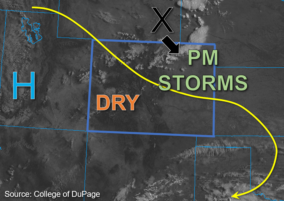
This morning, high pressure centered over the Utah and Nevada border continues to produce northwest flow aloft over Colorado. This drier air and subsidence should help to keep much of western Colorado dry this afternoon. The key change in today’s forecast from prior days is a shortwave trough over southeastern Wyoming, which is marked by the “X” in the visible satellite image below. This disturbance is expected to move southeast into the eastern plains this afternoon and help promote uplift in the area. With an upper-level jet also in the area and a convergence boundary at the surface, there should be sufficient dynamics to trigger isolated to widely scattered afternoon storms across the eastern plains and elevated ridges this afternoon. The best chance for storms is expected to be over the Northeast Plains, Palmer Ridge, and the higher terrain south.
While column moisture is not overly impressive this morning with PW values of 0.53 inches and 0.63 inches measured in Grand Junction and Platteville, respectively, surface moisture across the eastern plains is slightly higher than in prior days with the addition of some moisture from the shortwave. Dew points above 60°F are noted across the far eastern border counties, while dew points are currently in the 50s°F closer to the foothills and over far southwest Colorado. This surface moisture is expected to mix out somewhat today, which means that storms that do develop should have elevated bases with the primary threats being gusty winds. Instability should be fairly marginal across the state this afternoon with values forecast to reach between 800 to 1000 J/kg of CAPE across northeastern Colorado. DCAPE values averaging above 1200 J/kg for eastern Colorado increases confidence that storms are likely to produce strong downdrafts with damaging wind gusts possible. In addition to surface moisture lacking, faster southeast steering flow in the 20mph range means that storms should produce only moderate rainfall. Therefore, NO flooding is expected today for eastern Colorado.
For southwest portions of the state slower steering flow is expected, but so is lesser moisture. Some isolated heavy rainfall is possible over the higher elevations southwest given forecast moderate instability between 1200 and 1500 J/kg. However, with surface moisture expected to mix out throughout the day due to increasing subsidence and dry air moving in from the west, rain rates are expected to remain below flood thresholds. Therefore, NO flooding is expected.
Today’s Flood Threat Map
For more information on today’s flood threat, see the map below. If there is a threat, hover over the threat areas for more details, and click on burn areas to learn more about them. For Zone-Specific forecasts, scroll below the threat map.

Zone-Specific Forecasts:
Front Range, Urban Corridor, Northeast Plains, Palmer Ridge, Southeast Plains, Raton Ridge, & Southeast Mountains:
A few widely scattered showers and weak storms are noted across the Northeast Plains this morning. Storm coverage should become more scattered this afternoon across both the Northeast and Southeast Plains as well as the Palmer Ridge, with storms moving southeast through this evening. With somewhat limited moisture, storms are expected to produce gusty outflow winds, lightning, and perhaps some small hail. Given the faster storm movement today, max 1-hour rain rates up to 1 inch are possible over the plains, with 1-hour rain rates up to 0.4 inches possible over the Palmer Ridge and northern Southeast Mountains. Flooding is NOT expected today.
Primetime: Ongoing to Midnight
Southwest Slope, San Juan Mountains, San Luis Valley, Grand Valley, Central Mountains, Northern Mountains, & Northwest Slope:
Some scattered high clouds were noted across western Colorado on visible satellite imagery this morning, and cumulus should increase this afternoon with increasing upslope flow. However, dry air continues to move in from the west, and with the building high pressure and subsidence, storms over the southwest portions of the state should be short lived and of weaker intensity. Max 30-to-45-minute rain rates up to 0.6 inches will be possible over the southern San Juan Mountains, with a few storms possibly spilling into the southern San Luis Valley and producing up to 0.3-inch rain rates over a 30-to-45-minute period. NO Flooding is expected today.
Primetime: 3PM to 10PM