FTB 05-11-2021: Wet & Chilly Weather

Issue Date: Tuesday, May 11th, 2021
Issue Time: 9:40AM MDT

— Flooding is NOT expected today

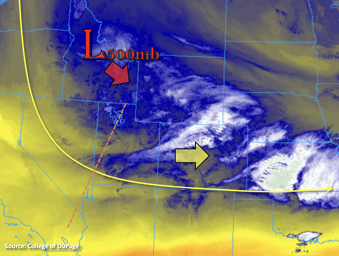
It’s a cold and wet start to the morning across the state. Temperatures below (red numbers) show freezing conditions for the majority of the state with the exception of the lowest elevations (eastern plains and western slope). Currently, fog is present over the mountain valleys, along with a rain/snow mix for the eastern plains and patchy, moderate snowfall over the Northern Mountains. The upper Low will traverse eastward across the northern portion of the state today, which will produce upslope flow over the region outlined in black below. So, although there is a slight break in precipitation now, it is forecast to pick back up early this afternoon.

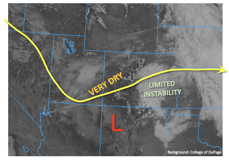
Soundings this morning show that drier air has worked its way into the atmosphere above 600mb both east and west of the Continental Divide. Thus, PW values have dropped off about a tenth of an inch from yesterday and were measured around 0.40 inches. With the Low overhead helping to provide lift and plenty of moisture, an increase in precipitation is forecast over the Northern Mountains, Front Range, Urban Corridor and Palmer Ridge early this afternoon. Over the highest elevations, this will be in the form of snow, over the plains rainfall is most likely, and over the foothills and elevated Palmer Ridge mixed precipitation will likely occur. Once again, limited instability and lower PW values mean more stratiform precipitation with perhaps only a little embedded convection. With precipitation rates well below flooding thresholds and more snow for the mountains, flooding is not forecast. Precipitation should start to come to an end this evening, first east then west.

Today’s Flood Threat Map

For more information on today’s flood threat, see the map below. If there is a threat, hover over the threat areas for more details, and click on burn areas to learn more about them. For Zone-Specific forecasts, scroll below the threat map.

Zone-Specific Forecasts:

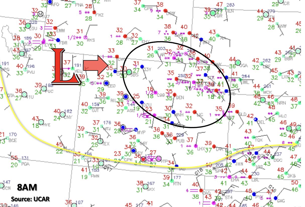
Northwest Slope, Northern Mountains, Central Mountains, Front Range, Urban Corridor, Northeast Plains & Palmer Ridge:

Another 6-8 inches could fall this afternoon over the Front Range and Northern Mountains above 8K feet making for messy traveling conditions. The Winter Storm Warning issued by the NWS remains in effect until 6PM. Over the Northern Mountains and Southwest Slope, totals up to 0.75 inches and 0.50 inches will be possible, respectively. Over the Urban Corridor and western Palmer Ridge, totals up to 0.75 inches will be possible by morning with a rain/snow mix over the Palmer Ridge. Ongoing rainfall should become more discrete over the Northeast Plains by this afternoon/evening, and isolated totals just under 0.50 inches are possible. Precipitation will end from east to west starting early this evening.

It is likely that with precipitation over the last couple of days, the Calwood burn area soils are saturated. With a rising freezing line throughout the day, precipitation this afternoon may fall as rainfall over the burn area. Although hourly rain rates are below flood threat criteria today, 24-hour totals could add another 0.25 inches to the area making soils unstable. Thus, a Low flood threat will be issued for extra caution.

Primetime: Ongoing to 10PM

Grand Valley, San Juan Mountains, Southwest Slope, San Luis Valley, Southeast Plains, Southeast Mountains & Raton Ridge:

Current rainfall over the Southeast Plains should start to come to an end by about noon as favorable lift and moisture moves away from the area. Some weak showers may be possible these evening as the Low moves east over the area. Overall, it is looking to be dry and cool for the mountains, Raton Ridge and Southeast Plains. Back to the west, temperatures will reach into the mid-60Fs over the Grand Valley, Southeast Slopes and San Luis Valley with plenty of sunshine to go around.

FTB 05-10-2021: Precipitation & Cooler Temperatures Continue

Issue Date: Monday, May 10th, 2021
Issue Time: 9:10AM MDT

— Flooding is NOT expected today

The trough of low pressure to our northwest will continue to influence Colorado’s weather today. Currently, there is precipitation and some fog being reported over the Central Mountains, Front Range, Palmer Ridge and eastern plains along with plenty of cloud cover. The low pressure system (marked below) is expected to move slowly south and then eastward throughout the day, which will produce strong westerly flow aloft across the state. With plenty of lift continuing due to the favorable dynamics overhead, beneficial precipitation is forecast for the majority of the state through tomorrow morning.

Cooler temperatures and PW around 0.50 inches both east and west of the Continental Divide mean instability will be limited, so more stratiform precipitation is forecast. Additionally, the snowline is expected to fall throughout the day and overnight night, so expect more snow for the mountains and elevated regions of the western slope and eastern plains by morning. Even if some weak embedded convection develops this afternoon and evening within the stratiform rainfall, only a slight increase in rain rates is forecast. Therefore, flooding is NOT forecast today. Finally, with snow forecast over the highest terrains and lower rain rates forecast before the crossover to snow for the mid-elevations, flooding over burn areas is not forecast.

Today’s Flood Threat Map

For more information on today’s flood threat, see the map below. If there is a threat, hover over the threat areas for more details, and click on burn areas to learn more about them. For Zone-Specific forecasts, scroll below the threat map.

Zone-Specific Forecasts: 

Southeast Plains, Southeast Mountains, Raton Ridge, Northeast Plains, Front Range, Urban Corridor & Palmer Ridge:

Precipitation is forecast to pick up in coverage first north of I-70 this afternoon and evening, and then south of I-70 overnight and into tomorrow morning. Rainfall rates for the stratiform rainfall will be well under flood threat criteria, so flooding is NOT forecast. Isolated totals up to 1.50 inches will be possible over the northern Front Range/Urban Corridor by morning. Overnight, precipitation expands south and eastward. With rain turning to snow over the Southeast Mountains and elevated ridges, flooding is NOT forecast. Isolated totals by morning up to 2 inches (east) and 1.25 inches (west) are possible. Overall, this will be another system that brings beneficial precipitation to the spring soils.

Primetime: 10:30AM to ongoing

Northwest Slope, Northern Mountains, Central Mountains, Grand Valley, San Juan Mountains, Southwest Slope & San Luis Valley:

Slightly drier air will continue to protrude into the southwest corner of the state today (yellow shade above), so the lower elevations of the Southwest Slope will likely stay mostly dry. Only spotty rainfall coverage is forecast over the lower elevations of the Northwest Slope and Grand Valley this afternoon, and maybe a weak shower for the Northwest Slope tomorrow morning. Over the high terrains, expect a bit of a mix of rain and snow with precipitation accumulation favoring the Northern and Central Mountains. Totals by morning are generally expected to be between 0.50 and 0.75 inches with isolated totals just under 1 inch possible. Over the San Juan Mountains, general totals will be slightly less and with less coverage as well. The San Luis Valley could see a little precipitation if virga can make it to the valley floor tonight, but totals should remain under 0.10 inches. Flooding is NOT forecast.

Primetime: 11:30AM to Midnight

FTB 05-09-2021: Cooler, Rain Turning To Snow For Many, And No Flood Threat

Issue Date: Sunday, May 9th, 2021
Issue Time: 9:00AM MDT

— Flooding is NOT expected today

Happy Mother’s Day!

This morning’s visible satellite imagery, below, shows a developing surface cyclone over the Four Corners with a thick mid/low level cloud deck along with some showers and a weak storm or two in southern Colorado. While the dynamics with this system will certainly be impressive, the main missing piece preventing heavy rain potential is the moisture content. This morning’s PW at Grand Junction was only 0.18 inches, with 0.40 inches measured at Denver. However, even western KS and NE had PW below 0.5 inches, a noticeable drop since yesterday. Overall, this system has trended a bit drier since we first began watching it five days ago. In turn, this implies less instability and more stratiform, versus convective rainfall (and yes, snowfall). Maximum atmospheric instability today will be below 500 J/kg in southern and southeastern Colorado. This is far too low for anything besides a local, short-pulsed heavy downpour so flooding is NOT expected today. However, isolated severe weather, mainly in the form of strong winds and perhaps large hail, will be possible in southeast Colorado.

West of the Continental Divide, gusty winds and low relative humidity will continue to support conditions favorable for wildfires. Fortunately, the cooler temperatures will mitigate the threat somewhat, compared to Saturday. Stay tuned to National Weather Service forecasts for updates on this.

Today’s Flood Threat Map

For more information on today’s flood threat, see the map below. If there is a threat, hover over the threat areas for more details, and click on burn areas to learn more about them. For Zone-Specific forecasts, scroll below the threat map.

Zone-Specific Forecasts:

Raton Ridge and Southeast Plains:

Mostly cloudy and much cooler with scattered to widespread showers and a few thunderstorms through the day and into the evening. Maximum 1-hour rainfall up to 0.5 inches possible for most areas below 6,000 feet, but up to 0.9 inches in far southeast CO along the OK and KS borders. A severe storm, with large hail and gusty winds to 55mph cannot be ruled out in these areas. The snow level will drop from 8,000 feet this morning down to 6,000 feet later this evening and into the overnight hours.

The Spring Creek burn scar is not expected to have flooding concerns because precipitation will be transitioning to snow later today, if it hasn’t done so already.

Flooding is NOT expected today.

Primetime: Now through 6AM, with highest rainfall intensity between 1PM and 7PM

Northern Mountains, Front Range, Urban Corridor, Central Mountains, Palmer Ridge, Northeast Plains:

Increasing clouds and much cooler with isolated to scattered rain and snow showers developing later this afternoon and increasing in coverage overnight. A rumble of thunder cannot be ruled out. Max 1-hour rainfall up to 0.4 inches earlier in the afternoon. The snow level will drop from 7,500 feet this afternoon to 5,000 feet overnight.

Fire burn scars are not anticipated to experience flooding issues because of the combination of light rainfall intensity and transition of precipitation into snowfall.

Flooding is NOT expected today.

Primetime: 1PM through the overnight hours

Grand Valley, San Juan Mountains, Southwest Slope & San Luis Valley, Northwest Slope:

Mostly sunny to partly cloudy and cooler this afternoon. Rain and snow showers will increase in coverage this afternoon mainly for elevations above 7,500 feet. Below this level, it will be too dry for any significant precipitation. Max 1-hour rainfall up to 0.2 inches. A Red Flag warning is currently in effect for the San Luis Valley, so please stay tuned to your local NWS office for updates on fire conditions.

Flooding is NOT expected today.

FTB 05-08-2021: Changes Underway, But No Flood Threat; A Few Severe Storms Possible

Issue Date: Saturday, May 8th, 2021
Issue Time: 8:30AM MDT

— Flooding is NOT expected today

Significant changes have occurred in the atmosphere above Colorado over the past 24 hours. A transient ridge of high-pressure, responsible for warm temperatures on Friday, has been replaced by a trough of low pressure. As shown in the satellite image below, the trough axis is currently positioned just west of Colorado but will move across the state quickly today. Lee-side (i.e. to the east of the Rockies) surface pressure falls of up to 5 millibars over the past 6 hours were noted this morning, signifying the initial development of a low pressure circulation that will actually persist over the next 72-96 hours. However, despite the rather menacing dynamics aloft, heavy rainfall chances will be significantly constrained today by two factors. First, PW remains at or below seasonal normal today, with 0.48 inches measured at Grand Junction and a meager 0.26 inches in Denver. Higher PW, up to 0.75 inches was noted along the Nebraska and Kansas borders, but this is still below general thresholds that would signify a flood threat. Second, steering winds, measured at the 500mb level, will be strong (35mph+) and westerly today. The westerly part is important because there will be a tendency to import much drier air, currently over Great Basin eastward.

Translating all the factors above into an actual sensible forecast, we expect generally cooler temperatures and scattered showers and a few thunderstorms mainly across central and eastern parts of the state today. Highest rainfall intensity, up to 1.0 inch/hour locally, will be along the Kansas/Nebraska borders, where there is also a chance of severe weather including strong winds, large hail and possibly a few landspout tornadoes given the presence of low-level wind shear. However, flooding is NOT expected today.

West of the Continental Divide, gusty dry winds will create conditions favorable for wildfires, so Red Flag Warnings have been posted for parts of the area. Stay tuned to local NWS forecasts for more information.

Today’s Flood Threat Map

For more information on today’s flood threat, see the map below. If there is a threat, hover over the threat areas for more details, and click on burn areas to learn more about them. For Zone-Specific forecasts, scroll below the threat map.

Zone-Specific Forecasts:

Palmer Ridge, Southeast Plains and Northeast Plains:

Partly to mostly cloudy and cooler with scattered showers and thunderstorms starting in the early afternoon and persisting in the late evening hours. Max 1-hour rainfall up to 0.5 inches for western areas and 1 inch for eastern areas. Maximum 24-hour rainfall up to 1.7 inches locally will be possible along the Kansas border. Severe weather, including strong winds, large hail and an isolated tornado will be possible mainly along the Kansas border today. Flooding is NOT expected today.

Primetime: 12PM through the overnight hours

Northern Mountains, Front Range, Urban Corridor, Central Mountains:

Partly cloudy and cooler with isolated to scattered showers and weak thunderstorms this afternoon and into evening. Max 1-hour rainfall up to 0.5 inches. Gusty winds up to 50 mph are possible with the stronger storms. Flooding is NOT expected today.

Primetime: 12PM through the overnight hours

Grand Valley, San Juan Mountains, Southwest Slope & San Luis Valley, Northwest Slope, Southeast Mountains & Raton Ridge:

Mostly sunny to partly cloudy and windy this afternoon. An isolated rain shower cannot be ruled out for northern areas. Max 1-hour rainfall up to 0.1 inches. Flooding is NOT expected today. Red Flag Warnings are in effect for parts of the area. Stay tuned to local NWS offices for more information.