Issue Date: Saturday, May 8th, 2021
Issue Time: 8:30AM MDT
— Flooding is NOT expected today
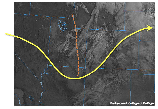
Significant changes have occurred in the atmosphere above Colorado over the past 24 hours. A transient ridge of high-pressure, responsible for warm temperatures on Friday, has been replaced by a trough of low pressure. As shown in the satellite image below, the trough axis is currently positioned just west of Colorado but will move across the state quickly today. Lee-side (i.e. to the east of the Rockies) surface pressure falls of up to 5 millibars over the past 6 hours were noted this morning, signifying the initial development of a low pressure circulation that will actually persist over the next 72-96 hours. However, despite the rather menacing dynamics aloft, heavy rainfall chances will be significantly constrained today by two factors. First, PW remains at or below seasonal normal today, with 0.48 inches measured at Grand Junction and a meager 0.26 inches in Denver. Higher PW, up to 0.75 inches was noted along the Nebraska and Kansas borders, but this is still below general thresholds that would signify a flood threat. Second, steering winds, measured at the 500mb level, will be strong (35mph+) and westerly today. The westerly part is important because there will be a tendency to import much drier air, currently over Great Basin eastward.
Translating all the factors above into an actual sensible forecast, we expect generally cooler temperatures and scattered showers and a few thunderstorms mainly across central and eastern parts of the state today. Highest rainfall intensity, up to 1.0 inch/hour locally, will be along the Kansas/Nebraska borders, where there is also a chance of severe weather including strong winds, large hail and possibly a few landspout tornadoes given the presence of low-level wind shear. However, flooding is NOT expected today.
West of the Continental Divide, gusty dry winds will create conditions favorable for wildfires, so Red Flag Warnings have been posted for parts of the area. Stay tuned to local NWS forecasts for more information.
Today’s Flood Threat Map
For more information on today’s flood threat, see the map below. If there is a threat, hover over the threat areas for more details, and click on burn areas to learn more about them. For Zone-Specific forecasts, scroll below the threat map.

Zone-Specific Forecasts:
Palmer Ridge, Southeast Plains and Northeast Plains:
Partly to mostly cloudy and cooler with scattered showers and thunderstorms starting in the early afternoon and persisting in the late evening hours. Max 1-hour rainfall up to 0.5 inches for western areas and 1 inch for eastern areas. Maximum 24-hour rainfall up to 1.7 inches locally will be possible along the Kansas border. Severe weather, including strong winds, large hail and an isolated tornado will be possible mainly along the Kansas border today. Flooding is NOT expected today.
Primetime: 12PM through the overnight hours
Northern Mountains, Front Range, Urban Corridor, Central Mountains:
Partly cloudy and cooler with isolated to scattered showers and weak thunderstorms this afternoon and into evening. Max 1-hour rainfall up to 0.5 inches. Gusty winds up to 50 mph are possible with the stronger storms. Flooding is NOT expected today.
Primetime: 12PM through the overnight hours
Grand Valley, San Juan Mountains, Southwest Slope & San Luis Valley, Northwest Slope, Southeast Mountains & Raton Ridge:
Mostly sunny to partly cloudy and windy this afternoon. An isolated rain shower cannot be ruled out for northern areas. Max 1-hour rainfall up to 0.1 inches. Flooding is NOT expected today. Red Flag Warnings are in effect for parts of the area. Stay tuned to local NWS offices for more information.