Issue Date: Sunday, May 23rd, 2021
Issue Time: 9:30AM MDT
— A LOW flood threat has been issued for parts of the Northeast Plains and Southeast Plains
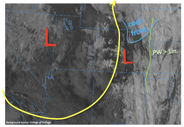
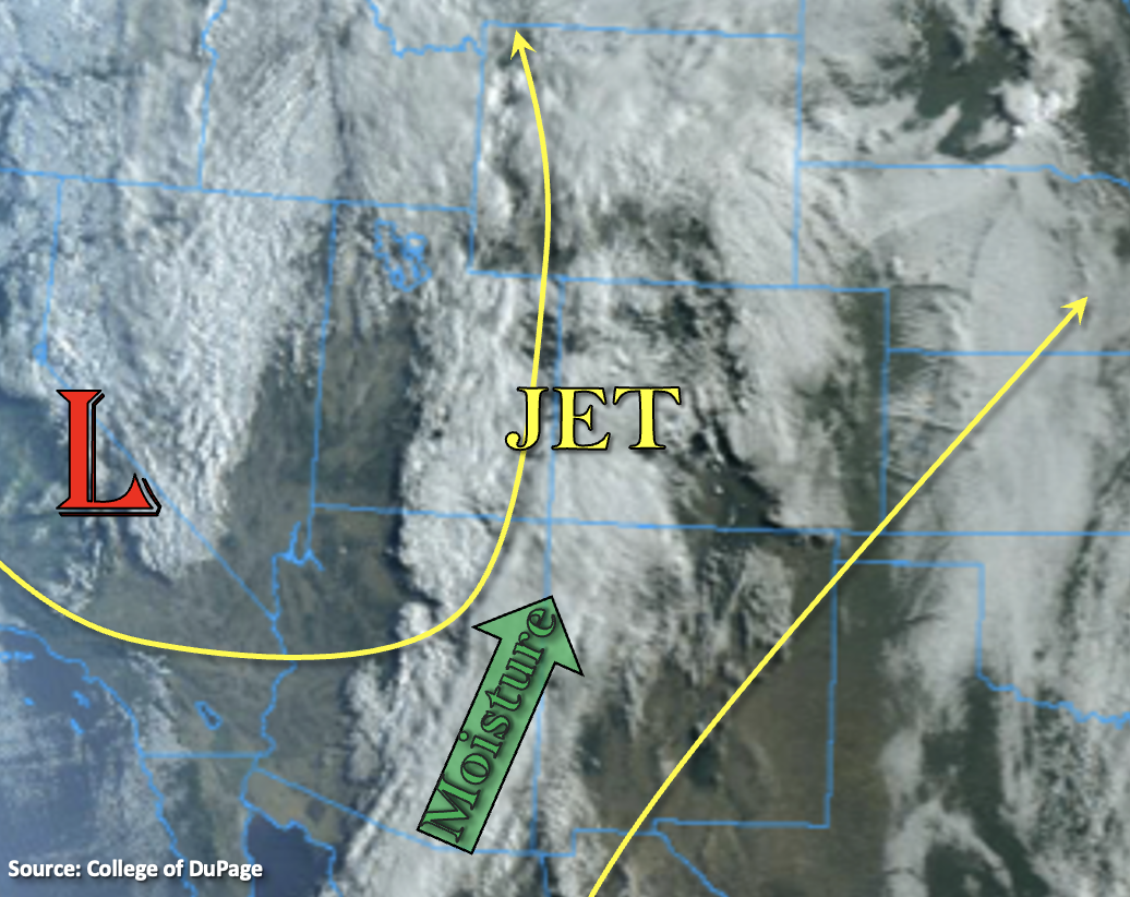
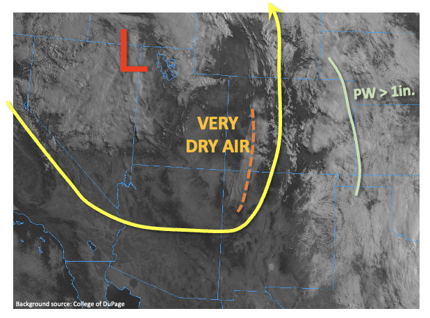
The strong upper-level trough, a staple of our weather since Thursday, has nearly stalled out over the Great Basin as shown in the visible satellite image, below. Colorado continues to be under its influence with deep southerly flow over the state, along with numerous disturbances embedded within that flow. Ongoing elevated convection is moving rapidly northward in eastern, with more redevelopment later this morning. However, there is a major difference in today’s atmosphere compared to Saturday. Very dry air has finally overtaken the western portion of the state. For example, this morning’s Grand Junction sounding had a PW of only 0.16 inches. Although this air will continue to progress eastward through the day, it will have resistance. Denver’s morning PW was 0.80 inches, which is much above average for late May. PW around 1 inch was noted along the Kansas border, some of which will make it back into northeast Colorado courtesy of southeastern boundary layer flow. The dry air will eventually win out, but not before another active afternoon mainly in the Northeast Plains and the northern part of the Southeast Plains.
Just like the past few days, the main concern regarding heavy rainfall is not necessarily the shorter duration 1-hour amounts, but the 2-hour and 3-hour durations given that storm motion will continue to favor training. On Saturday evening, this kind of scenario yielded more than 3 inches of rain in Las Animas county over a 2-3 hour period. For today, the area of concern is in the northeast quadrant of Colorado, along the NE and KS border, where up to 2.9 inches of rainfall over a 2-3 hour period will again be possible. Additionally, severe weather, notably large hail and damaging winds, will likely accompany the earlier storms, similar to Saturday but more isolated in nature.
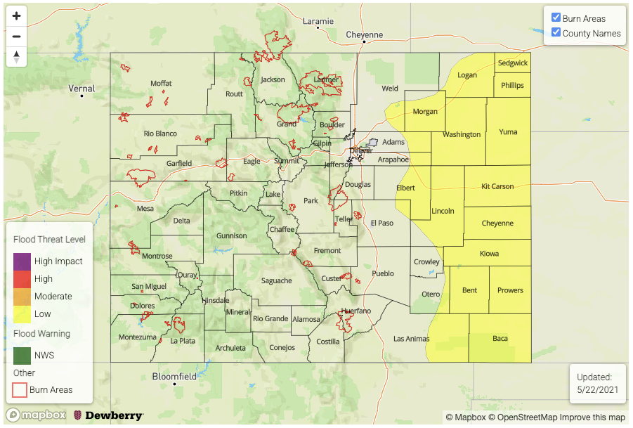
Today’s Flood Threat Map
For more information on today’s flood threat, see the map below. If there is a threat, hover over the threat areas for more details, and click on burn areas to learn more about them. For Zone-Specific forecasts, scroll below the threat map.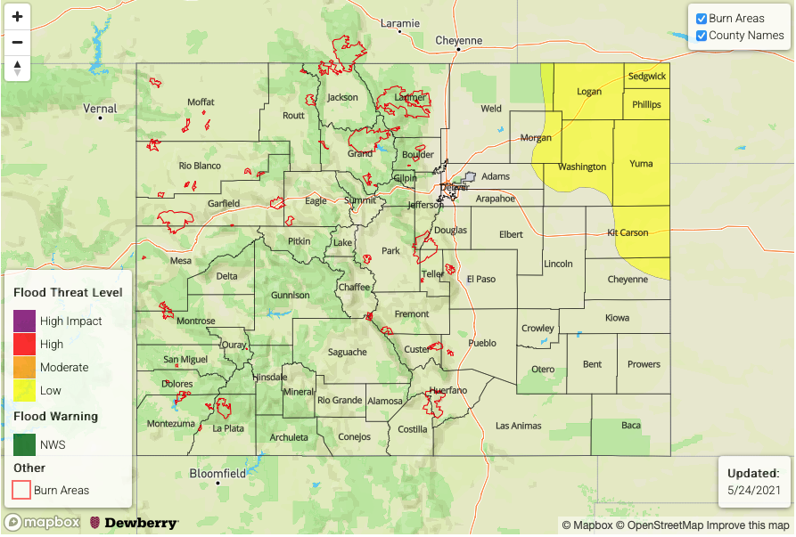
Zone-Specific Forecasts:
Northeast Plains, Southeast Plains
Scattered to widespread showers and thunderstorms continuing into the late evening hours. Max 1-hour rain up to 1.6 inches, with max 3-hr rain up to 2.9 inches. Isolated flash flooding, street and field flooding will be possible. Large hail and damaging winds are also possible with the earlier round of thunderstorms. A Low flood threat has been issued for parts of the region.
Primetime: 12PM through 11PM
Front Range, Urban Corridor, Southeast Mountains, Raton Ridge, Palmer Ridge:
Isolated to scattered showers and thunderstorms mainly through the late afternoon, then mostly sunny and much drier. Max 1-hour rainfall up to 0.7 inches. Flooding is NOT expected today.
Primetime: 12PM through 6PM
Grand Valley, Southwest Slope, San Luis Valley, San Juan Mountains, Central Mountains, Northern Mountains and Northwest Slope:
Warmer and drier with gusty winds in the afternoon. Flooding is NOT expected today.