Issue Date: Saturday, May 22nd, 2021
Issue Time: 9:30AM MDT
— A LOW flood threat has been issued for parts of the Northeast Plains, Palmer Ridge and Southeast Plains
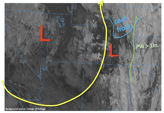
Another day of active weather is anticipated for Colorado, especially in eastern areas. As shown in the water vapor image, below, a large trough of low pressure is located over the Great Basin, leading to strong southerly flow across Colorado. Numerous disturbances within this flow will help trigger scattered to widespread showers and thunderstorms east of the Continental Divide. PW has generally increased in eastern areas, with values above 1 inch now noted along the eastern Colorado border. The Denver morning sounding showed a PW of 0.50 inch, right in line for this time of year, also indicating a very large gradient across the eastern part of the state. This, along with southerly steering flow will anchor today’s storms across a rather narrow corridor in eastern Colorado. Also of note was a strong cool front that pushed into CO from WY overnight, leading to a very stable airmass roughly north of I-76. Although some of this airmass will be pushed back northward, heavy rainfall chances will be capped north of this boundary.
We expect multiple rounds of showers and thunderstorms today, mainly east of the Continental Divide. With dewpoint temperatures as high as the low 60s F southeast of the cool front, there will be the potential for heavy rainfall. A Low flood threat has been issued, primarily for rainfall in the 1-hr to 3-hr duration. Isolated flash flooding, street and field flooding will be possible. In addition, severe weather in the form of large hail, damaging straight line winds and isolated tornadoes will also be possible especially with the earlier round of thunderstorms.
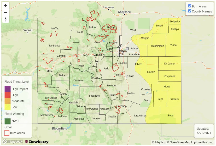
Today’s Flood Threat Map
For more information on today’s flood threat, see the map below. If there is a threat, hover over the threat areas for more details, and click on burn areas to learn more about them. For Zone-Specific forecasts, scroll below the threat map.
Zone-Specific Forecasts:
Northeast Plains, Palmer Ridge, Southeast Plains
Scattered to widespread showers and thunderstorms beginning this afternoon, and continuing into the early overnight hours. Max 1-hour rain up to 1.7 inches, with max 3-hr rain up to 3.0 inches. Isolated flash flooding, street and field flooding will be possible. Large hail, damaging winds and isolated tornado is also possible with the earlier round of thunderstorms. A Low flood threat has been issued for parts of the region.
Primetime: 1PM through 3AM
Front Range, Urban Corridor, Southeast Mountains, Raton Ridge:
Isolated to scattered showers and thunderstorms this afternoon and early evening. Max 1-hour rainfall up to 0.8 inches. Large hail and damaging winds will be possible with the strongest storms. Flooding is NOT expected today, although street ponding will be possible in urban areas.
Primetime: 12PM through 7PM
Grand Valley, Southwest Slope, San Luis Valley, San Juan Mountains, Central Mountains, Northern Mountains and Northwest Slope:
Warmer and drier with isolated to widely scattered showers and perhaps a thunderstorm especially in the San Juan Mountains and Central Mountains. Max 1-hour rainfall up to 0.3 inches. Flooding is NOT expected today.