Issue Date: Friday, May 21st, 2021
Issue Time: 9:45AM MDT
— Flooding is NOT expected today
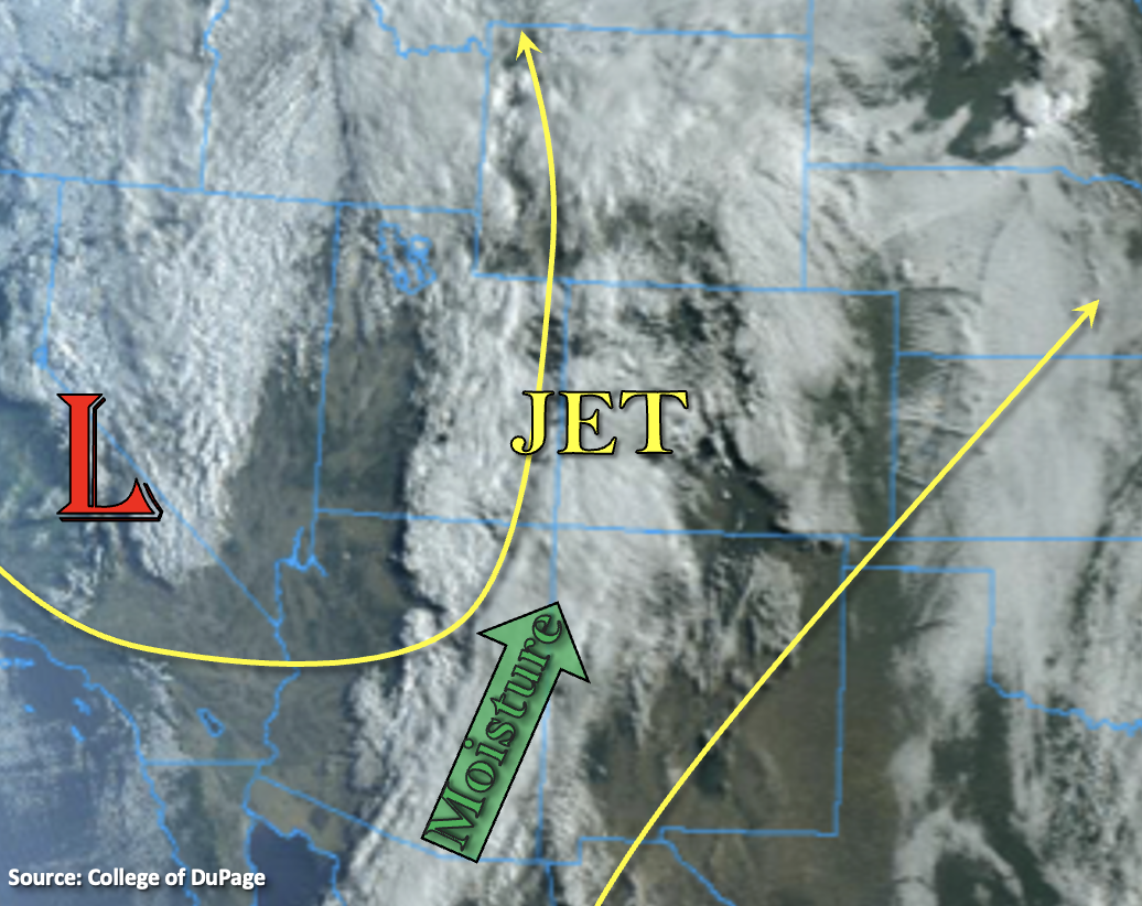
The upper Low (shown below) will continue to dig in-place today just to our west. A jet on the east side of the Low has is producing southeasterly and southerly winds, which has pulled a nice plume of moisture into western Colorado and eastern Utah. Not surprisingly, PW at Grand Junction has rebounded quite a bit to 0.63 inches with this band of moisture, which is around the 90th percentile for this time of year. The combination of the two, along with some weak mid-level energy, is helping to produce widespread showers and snow (~9-10K feet) across the western portion of the state this morning. Expecting this precipitation to pick up intensity (north) and coverage throughout the day as mid-level energy continues to move through the flow into the moisture-rich environment. However, a fairly dry surface layer, mild lapse rates, drier spring soils and a mixed precipitation at the highest elevations will limit the heavy rainfall and runoff threat. This should be a nice soaking through this evening with the highest totals by morning expected over the south and southwest facing slopes.
Over the eastern portion of the state, another dryline is forecast set up over the plains near Highway 59 with lee cyclone development. This means storms that develop on the west side of this line (eastern mountain and ridges) are expected to produce lower rainfall totals with plenty of virga/wind. Mid-level lift moving through the flow should help pop storms along the dryline this afternoon in an environment ripe for severe thunderstorms. The main threat from storms will be large hail, strong outflow winds and perhaps a tornado before a line of convection develops. Although there will be plenty of moisture in the area for high rain rates in the storm cores, fast storm motion with the jet overhead, should limit the flood threat. Thus, flooding is NOT forecast this Friday.
Today’s Flood Threat Map
For more information on today’s flood threat, see the map below. If there is a threat, hover over the threat areas for more details, and click on burn areas to learn more about them. For Zone-Specific forecasts, scroll below the threat map.
Zone-Specific Forecasts:
San Juan Mountains, Central Mountains, Northern Mountains, Northwest Slope, Grand Valley & Southwest Slope:
Expect storms to become more widespread across these regions by early afternoon as instability and increased lift develop over the area. South, ongoing rainfall and cloud cover will limit the amount of instability that can build, so only mild rainfall rates are forecast. Over the higher elevations, a snow/rain mix should also help limit the flood threat. Isolated precipitation totals up to 2.50 inches will be possible by morning with max 1-hour rain rates up to 0.40 inches.
Further north, some embedded convection is likely this afternoon with heating and mid-level energy moving through the flow. Max 1-hour rain rates up to 0.40 inches will be possible with snow for the highest elevations. Isolated storm totals up to 1 inch will be possible over the western Central Mountains/Grand Valley higher terrains by morning. Flooding is NOT forecast.
Primetime: Ongoing to Midnight
Palmer Ridge, Southeast Plains & Northeast Plains:
Severe weather returns to the plains with brisk southerly winds forecast throughout the day with the tightening pressure gradient. Expect storms to develop along a dryline this afternoon and form a line of convection by this evening. Although local heavy rainfall is possible with the storm cores, storm motion should be quick enough to limit the flood threat. Max 1-hour rain rates up to 1.50 inches (north) and 1.25 inches (south) will be possible. Large hail, strong outflow winds and a couple tornadoes are also possible with the severe storms that develop. Flooding is NOT forecast.
Primetime: 4PM to Midnight
Raton Ridge, Front Range, San Luis Valley, Southeast Mountains, & Urban Corridor:
Another warm day is ahead with breezy conditions. Isolated storms may develop over the Front Range and northern Southeast Mountains favoring areas along the Continental Divide. With surface moisture decreasing and strong upper-level steering flow, storms that are able to pop will have limited rainfall potential. Isolated totals up to 0.20 inches (north) will be possible with lower totals further south. As storms move off the high terrains, high cloud bases mean the main threat will be wind with the virga producing storms. Flooding is NOT forecast.
Primetime: 12:30PM to 8PM