FTB 06-24-2021: Widespread Showers and Thunderstorms

Issue Date: Thursday, June 24th, 2021
Issue Time: 9:45AM MDT

— A LOW flood threat has been posted for parts of the San Juan Mountains, Central Mountains, Grand Valley, Northwest Slope, Northern Mountains, Palmer Ridge and Northeast Plains
— Threat will continue later than usual, into the early overnight hours

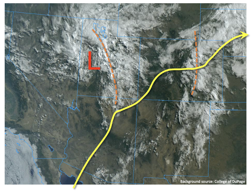
An early dose of monsoonal moisture has finally saturated the lower portion of the atmospheric column, which will allow for much more rainfall coverage today. As shown in the visible satellite image, below, southwesterly flow continues aloft over Colorado, with two notable disturbances seen in the cloud field. PW has increased markedly today, going from 0.50 inches to 0.94 inches at Grand Junction today (much above normal for late June), and also up to 0.90 inches at Denver. Once again, almost all weather model guidance continues to underestimate near-surface and total-column moisture. For example, this morning’s RAP analysis underestimated PW at Grand Junction and Denver by at least 15%. Furthermore, high-res guidance, notable the HRRR, continues to mix out moisture and underestimate dewpoint temperatures by at least several degrees Fahrenheit every afternoon.

For today, there are two areas of concern for heavy rainfall. First, east of the Continental Divide, weak upslope flow is expected to develop over northeast Colorado (especially south of I-76), which will support marginally heavy rainfall at the 1-3 hour duration from the climatologically favored Palmer Ridge east-northeastward. A Low flood threat has been posted for this region. Second, west of the Continental Divide, a developing disturbance over Utah will trek eastward into Colorado this afternoon, providing synoptic-scale lift. Mainly cloud-free skies this morning will quickly provide moderate instability (CAPE up to 800J/kg with a convective temperature at Grand Junction of only 83F) and support several rounds of showers and thunderstorms mainly over the higher terrain above 6,000 feet. Storms will be capable of 30-60 minute pulses of heavy rainfall up to 1.2 inches/hour. A Low flood threat has been posted for parts of this region for isolated flash flooding as well as debris slides and mud flows.

Lastly, today will provide the summer’s first “test” of the Grizzly Creek and Pine Gulch burn areas. See the Fire Burn Forecast page for forecasts for these and other large burn areas. One reminder on days like today is that our products are outlook-based and thus not meant to serve as real-time warnings. Please stay tuned to local NWS offices for any flood-related warning products.

Today’s Flood Threat Map

For more information on today’s flood threat, see the map below. If there is a threat, hover over the threat areas for more details, and click on burn areas to learn more about them. For Zone-Specific forecasts, scroll below the threat map.
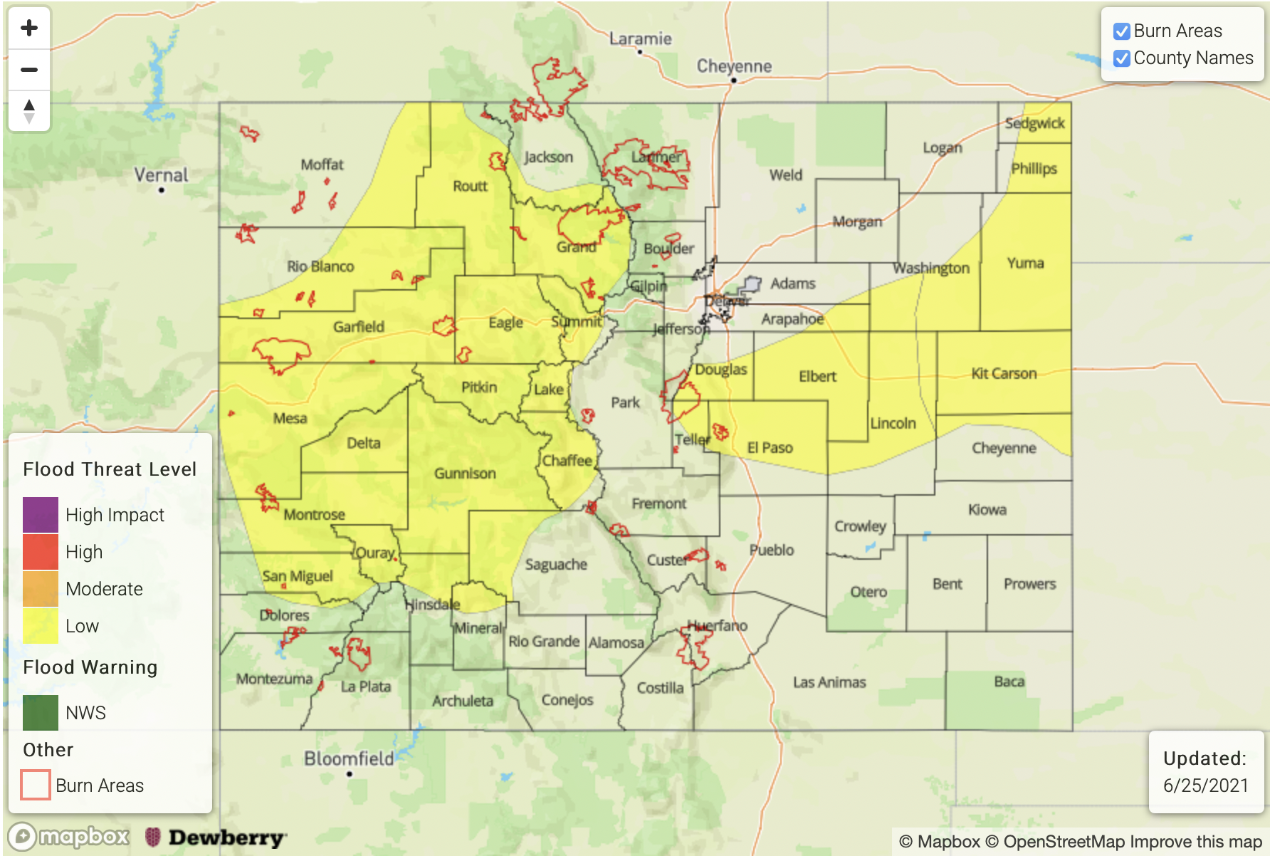
Zone-Specific Forecasts:

Grand Valley, Southwest Slope, Northwest Slope, Central Mountains and Northern Mountains:

Mostly cloudy with widespread showers and thunderstorms increasing in coverage this afternoon, and persisting through the early overnight hours. Max 30-minute rainfall up to 0.8 inches will be possible, with max 1-hour rainfall up to 1.2 inches. A Low flood threat has been posted for parts of the region, for isolated flash flooding, debris slides and mud flows.

Primetime: 11AM through midnight

Palmer Ridge, Northeast Plains and Southeast Plains:

Partly cloudy with scattered to numerous showers and thunderstorms developing this afternoon and lasting into the early overnight hours. Max 1-hour rainfall 2.1 inches (east) and 1.4 inches (west) supports a Low flood threat. Large hail and damaging wind will also be possible with the strongest cells near the KS/NE border.

Primetime: 2PM through 10PM (west) and 2AM (east)

Front Range, Urban Corridor, Raton Ridge, Southeast Mountains, San Juan Mountains and San Luis Valley:

Partly cloudy with scattered showers and thunderstorms this afternoon and early evening. Max 1-hour rainfall up to 0.9 inches (east of Continental Divide) and 0.6 inches (west). Flooding is NOT expected today although nuisance street ponding will be possible in urban areas.

Primetime: 1PM through 10PM
FTB 06-23-2021: First Monsoon Moisture Arrives, But Rainfall Limited Today; Rainfall To Increase Tomorrow

Issue Date: Wednesday, June 23rd, 2021
Issue Time: 9:15AM MDT

— Flooding is NOT expected today

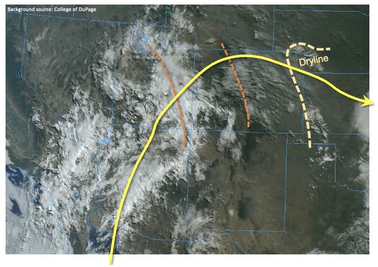
As seen in the visible satellite image, below, the season’s first pulse of monsoonal moisture has quickly arrived into the southwest US this morning. Surface and total column moisture has increased dramatically mainly southwest of Colorado into Arizona and western New Mexico. The trajectory of that moisture pulse is heading straight into our state later today and especially by tomorrow. However, it will take most of today to saturate the atmospheric column and prime it for rainfall generation. This morning’s PW at Grand Junction was 0.50 inches, but is expected to rise significantly over the next 12-24 hours. Beginning this afternoon, we expected isolated to scattered shower and weak thunderstorm activity to enter southwest Colorado and spread north and east over the higher terrain along the Continental Divide. Rainfall intensities will be well below flood thresholds, but any rainfall will be beneficial over the drought-stricken area. Unfortunately, the bigger threat today will be dry lightning, adding to the challenges with the ongoing wildfire activity.

East of the Contintental Divide, downsloping flow will generally suppress any rainfall, leading to hazy, warm weather this afternoon as smoke continues to advect eastward in the steering flow. However, along the KS and NE border, a strong dryline will develop this afternoon, providing a notable convergence boundary for strong-to-severe afternoon thunderstorms (if they can break the convective “cap”). The odds of storm formation is limited, but if they do form, large hail, damaging winds and an isolated tornado will all be possible. Brief heavy rainfall will also be possible, but steering winds should quickly take the storms out of Colorado, thus mitigating any flood threat.

So overall, we expect a gradual increase in rainfall coverage today, but flooding is NOT expected. Much more active weather is expected for tomorrow so stay tuned to tomorrow’s FTB.

Today’s Flood Threat Map

For more information on today’s flood threat, see the map below. If there is a threat, hover over the threat areas for more details, and click on burn areas to learn more about them. For Zone-Specific forecasts, scroll below the threat map.

Zone-Specific Forecasts:

Grand Valley, Southwest Slope, Northwest Slope, Central Mountains, Northern Mountains, Southeast Mountains, San Juan Mountains and San Luis Valley:

Mostly cloudy with isolated to scattered showers and weak thunderstorms developing later this morning, and persisting into the early overnight hours. Max 1-hour rainfall up to 0.4 inches so flooding is NOT expected today. A Red Flag Warning is in effect for parts of the region, primarily due to the threat of dry lightning today.

Primetime: 1PM through midnight

Northeast Plains, Southeast Plains:

Mostly sunny early then partly cloudy with isolated to widely scattered thunderstorms possible mainly along the KS/NE border. Max 1-hour rainfall up to 1.2 inches. Large hail, damaging winds and an isolated tornado will be possible with the strongest storm.

Primetime: 3PM through 10PM

Front Range, Urban Corridor, Raton Ridge and Palmer Ridge:

Partly cloudy and hazy with isolated to widely scattered showers or weak storms possible later this afternoon and into the evening hours. Max 1-hour rainfall up to 0.4. inches. Gusty winds will be possible due to the dry sub-cloud layer.

Primetime: 4PM through 10PM

FTB 06-22-2021: A Couple High-Based Storms Possible East with Hot Temperatures Returning Statewide

Issue Date: Tuesday, June 22nd, 2021
Issue Time: 9:10AM MDT

— Flooding is NOT expected today

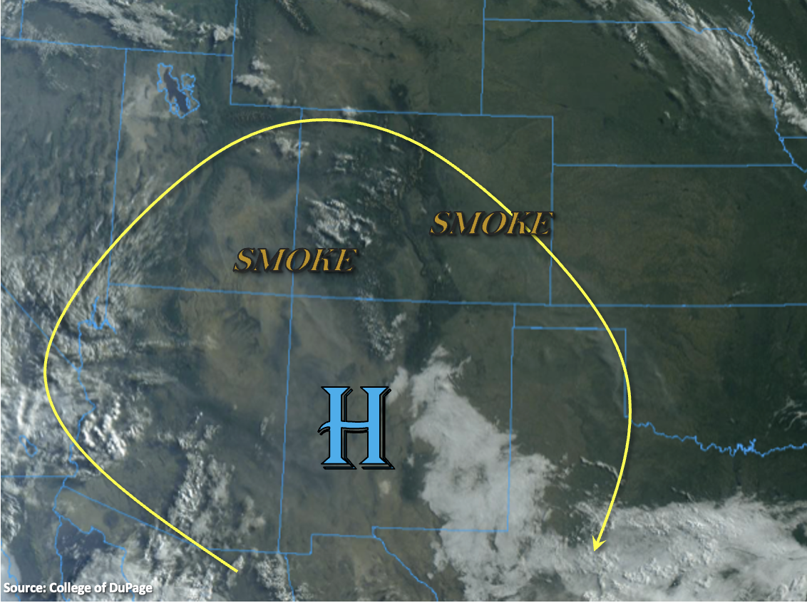
Not much change in the overall pattern today as the High continues to reinforce a dry air mass with west and northwesterly flow aloft. The ridge will begin to slide in from the west, so hot afternoon temperatures will return. There’s also a fair amount of smoke across the state from the ongoing wildfires in the area. Western Colorado has a little bit of moisture around 500mb that is helping produce the clouds over the western mountains in the visible satellite imagery below. While Grand Junction’s morning sounding measured near average PW at 0.62 inches, the moisture’s location in the mid-level of the atmosphere will make it difficult for any rainfall to reach the surface. Thus, the shortwave energy moving overhead this afternoon should only produce an increase cloud cover over northwestern Colorado. A Red Flag Warning has been issued for all areas west of the Continental Divide from noon to 9PM today.

Back over eastern Colorado, PW at Denver has dropped 0.32 inches over the last 24-hours to 0.42 inches. So, it’s quite dry, which will reduce the rainfall chances this afternoon to near zero. A couple high-based showers are possible south (mainly Southeast Mountains/Raton Ridge), but only light rainfall accumulations with possible strong outflow winds are forecast. Therefore, flooding is NOT forecast today.

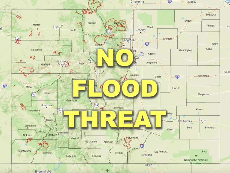
Today’s Flood Threat Map

For more information on today’s flood threat, see the map below. If there is a threat, hover over the threat areas for more details, and click on burn areas to learn more about them. For Zone-Specific forecasts, scroll below the threat map.

Zone-Specific Forecasts:

San Juan Mountains, Central Mountains, Northern Mountains, Grand Valley, Southwest Slope & Northwest Slope:

It’s going to be hot this afternoon with highs reaching the upper 90Fs across the lower elevations and upper 80Fs over the mountain valleys. The moisture’s location in the mid-level of the atmosphere translate to an increase in cloud cover without measurable rainfall this afternoon. Flooding is NOT expected. A Red Flag Warning has been issued for all regions, so be cautious with any activities that could cause a spark. Near surface smoke should mix out over the Southwest Slope, but it will likely increase over the southern mountains and Northwest Slope this afternoon and evening.

Southeast Mountains, Front Range, Palmer Ridge, Raton Ridge, Urban Corridor, San Luis Valley, Northeast Plains & Southeast Plains:

A couple high-based, storms could form over the southern Front Range, Southeast Mountains, adjacent plains (south) and elevated ridges late this afternoon and early evening. Light rainfall accumulations up to 0.10 inches will be possible along with plenty of virga. The main threat will be lightning and outflow winds from the stronger storms that can develop (south). Highs will rebound into the 90Fs across the lower elevations with 80Fs for the mountain valleys, so I hope you enjoyed that brief cool down for the summer solstice. Flooding is NOT forecast.

Primetime: 3PM to 9:30PM


FTB 06-21-2021: Stable Conditions Reduced Precipitation Chances This Afternoon

Issue Date: Monday, June 21st, 2021
Issue Time: 8:45AM MDT

— Flooding is NOT expected today

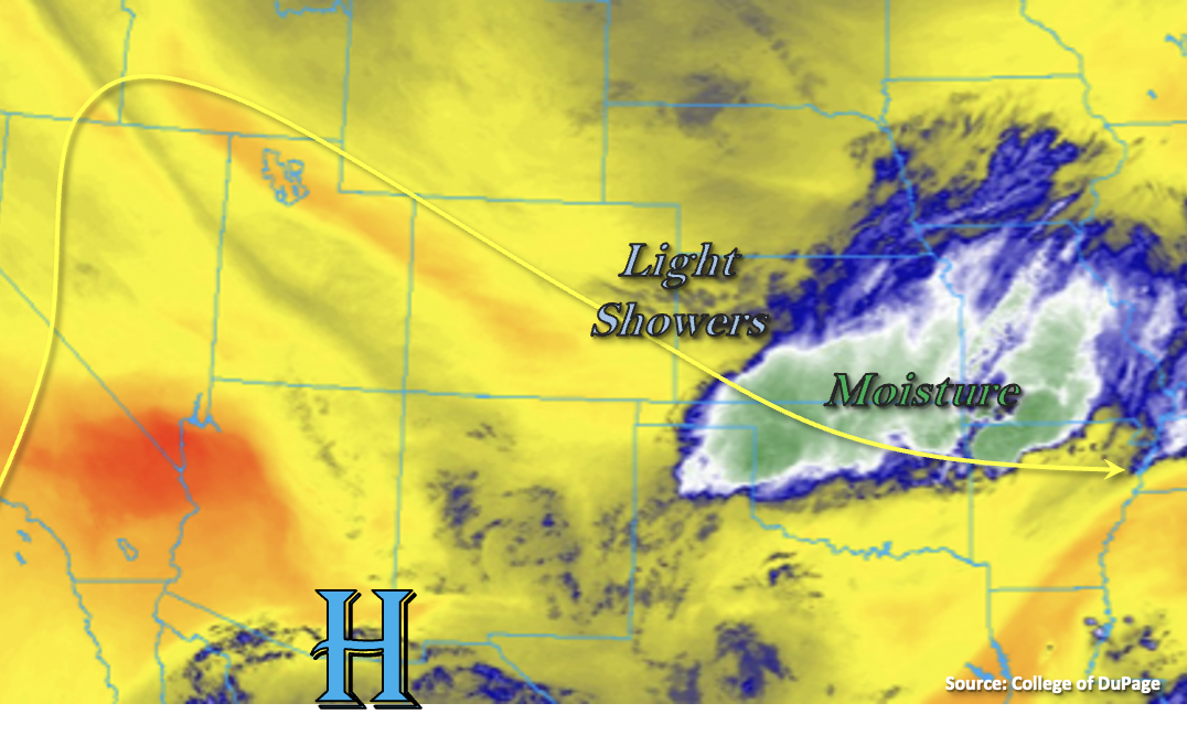
Eastern and northern Colorado are enjoying a cooler start to the morning behind the second reinforcing cold front that passed through the state. Pockets along the I-25 Urban Corridor are as much as 8 to 12F cooler than this time yesterday. Enjoy it while it lasts because hot temperatures are returning in a couple days! There is a tail of moisture from the disturbance yesterday that is combining with the jet to produce a line of light showers this morning over the eastern plains (Limon to Cheyenne Wells). Additional weak showers are present over the Southeast Mountains. These ongoing showers will likely continue through midday, but are expected to weaken throughout the morning and produce only minimal accumulations.

The center of the High continues to sit south and west of the state, which is producing northwesterly flow aloft. The main difference in today’s weather is that there are no disturbances forecast to move through the flow. The warmer and drier northwesterly flow will also help to stabilize and reduce the chances of precipitation this afternoon by creating an inversion aloft. A couple isolated, weak showers may be possible over the eastern mountains (southern border), if they can overcome the cap. Other than that, rainfall is not forecast over eastern Colorado this afternoon and evening.

Back to the west, it will be cooler north and hot again south as the front stalls out near the Grand Valley. Windy, dry and hot conditions are forecast again over the Grand Valley and Southwest Slope, so a Red Flag Warning has been re-issued. Rainfall is not forecast today, but some cloud cover over the mountains (south) may help a little with the heat this afternoon. Flooding is NOT forecast.

Today’s Flood Threat Map

For more information on today’s flood threat, see the map below. If there is a threat, hover over the threat areas for more details, and click on burn areas to learn more about them. For Zone-Specific forecasts, scroll below the threat map.

Zone-Specific Forecasts:

Southeast Mountains, Front Range, Urban Corridor, Palmer Ridge Northeast Plains, Southeast Plains & Raton Ridge:

There’s a light line of showers over the eastern plains this morning that will continue through about noon. Elsewhere, the inversion aloft should keep precipitation chances near zero. A couple weak storms may form over the Southeast Mountains (southern border) this afternoon, but flooding is NOT forecast. Cooler temperatures are also forecast today with highs in the 70Fs for the lower elevations and upper 60Fs for the elevated ridges and mountain valleys.

Primetime: Ongoing to Noon

Grand Valley, Southwest Slope, San Luis Valley, Northwest Slope, San Juan Mountains, Central Mountains & Northern Mountains:

Rainfall is not forecast this afternoon, but cooler temperatures in the 80Fs are forecast north of the cold front (Northwest Slope/Northern Mountains). It will remain dry, windy and hot further south and a Red Flag Warning has been issued for the Grand Valley and Southwest Slope. Near surface smoke should be reduce throughout the day, but it will likely increase this afternoon over the Northwest Slope. Flooding is NOT forecast.