FTB 07-02-2021: Low Flood Threat Returns for Eastern Mountains and Adjacent Plains

Issue Date: Friday, July 2nd, 2021
Issue Time: 9:40AM MDT
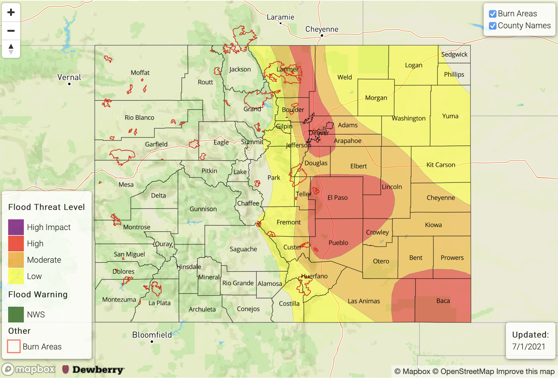
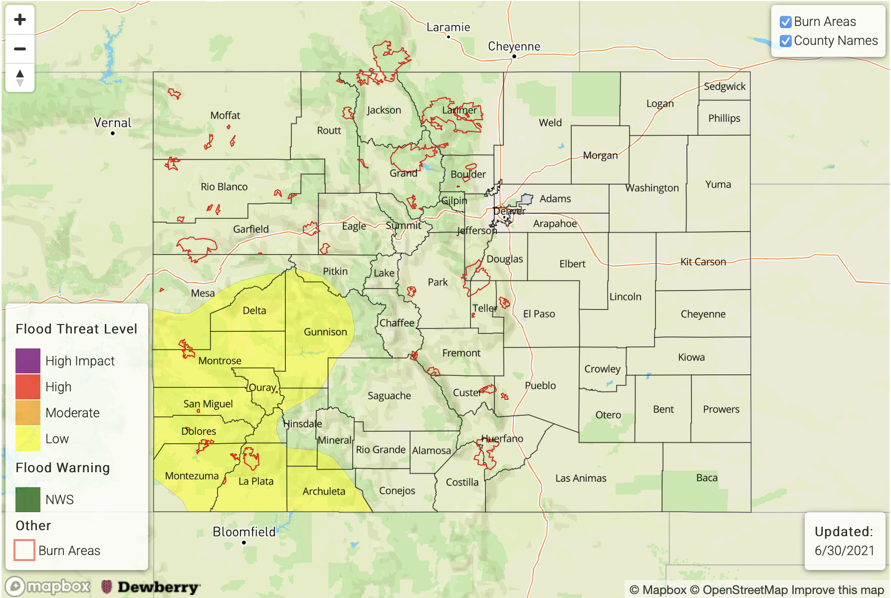
LOW flood threat has been issued for the Southeast Mountains, Raton Ridge and portions of the Front Range, Central Mountains, Urban Corridor and Palmer Ridge

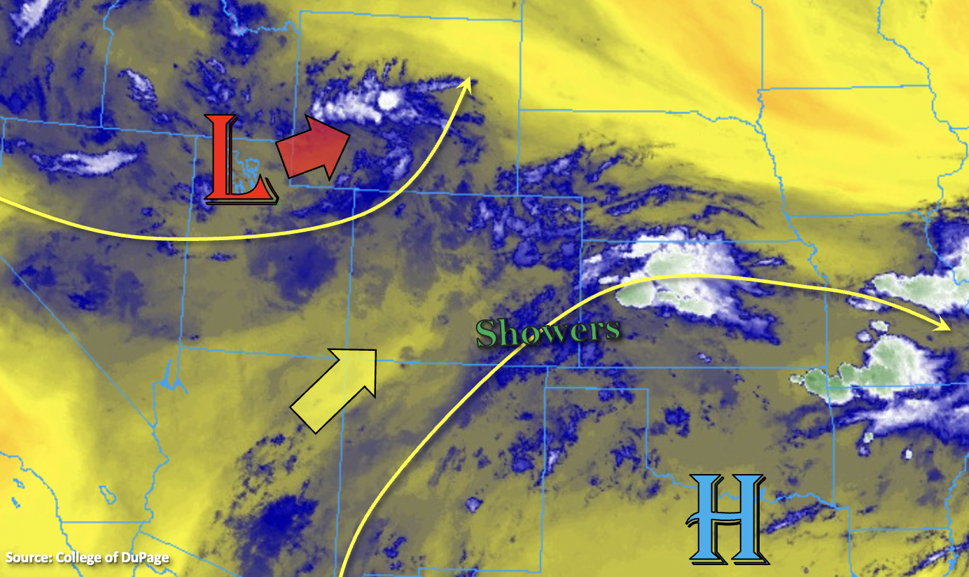
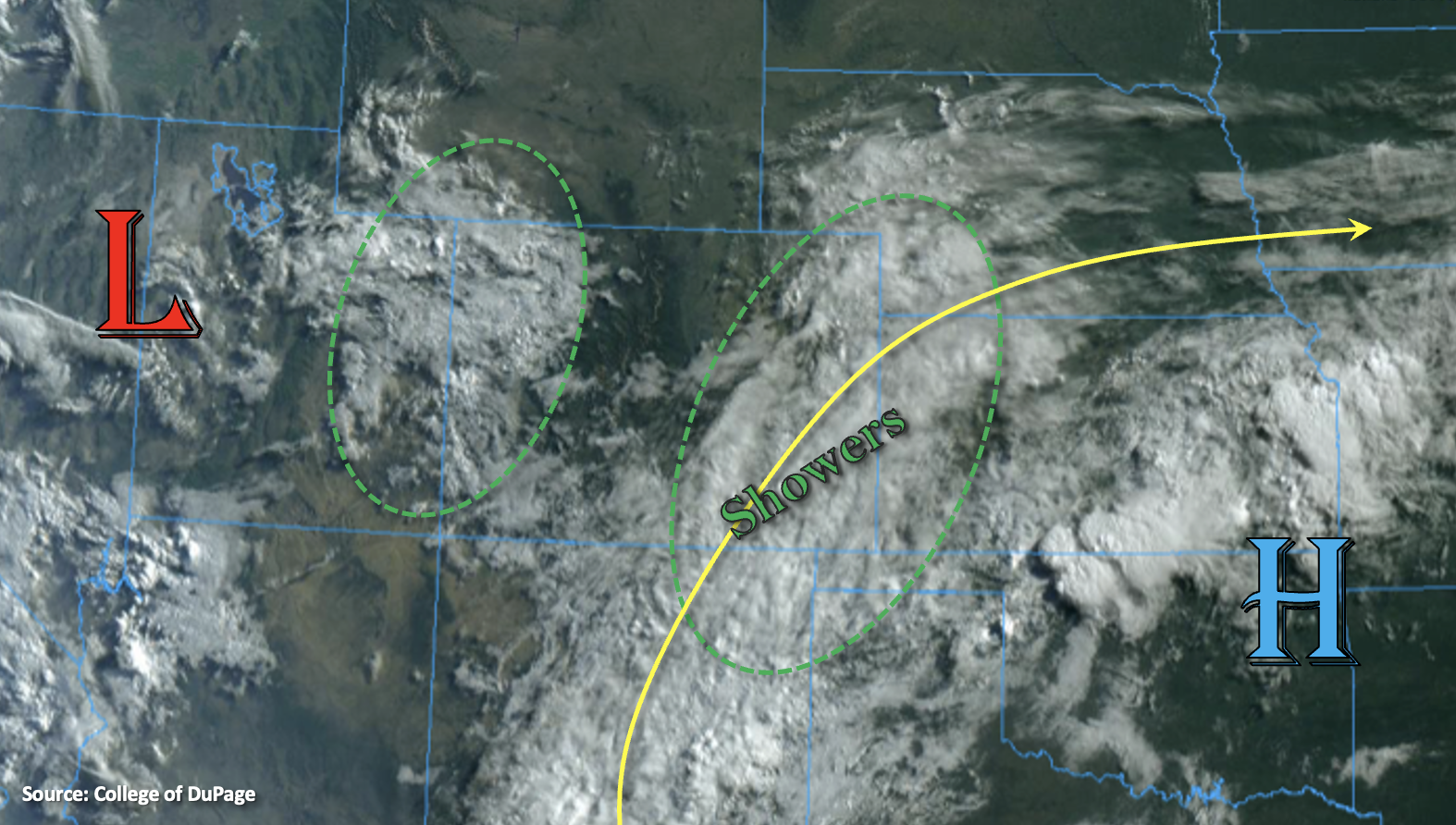
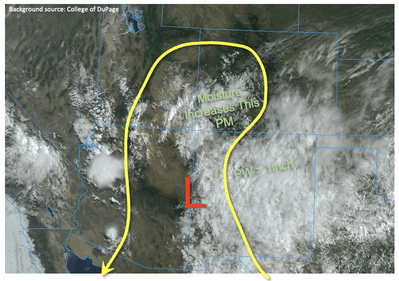
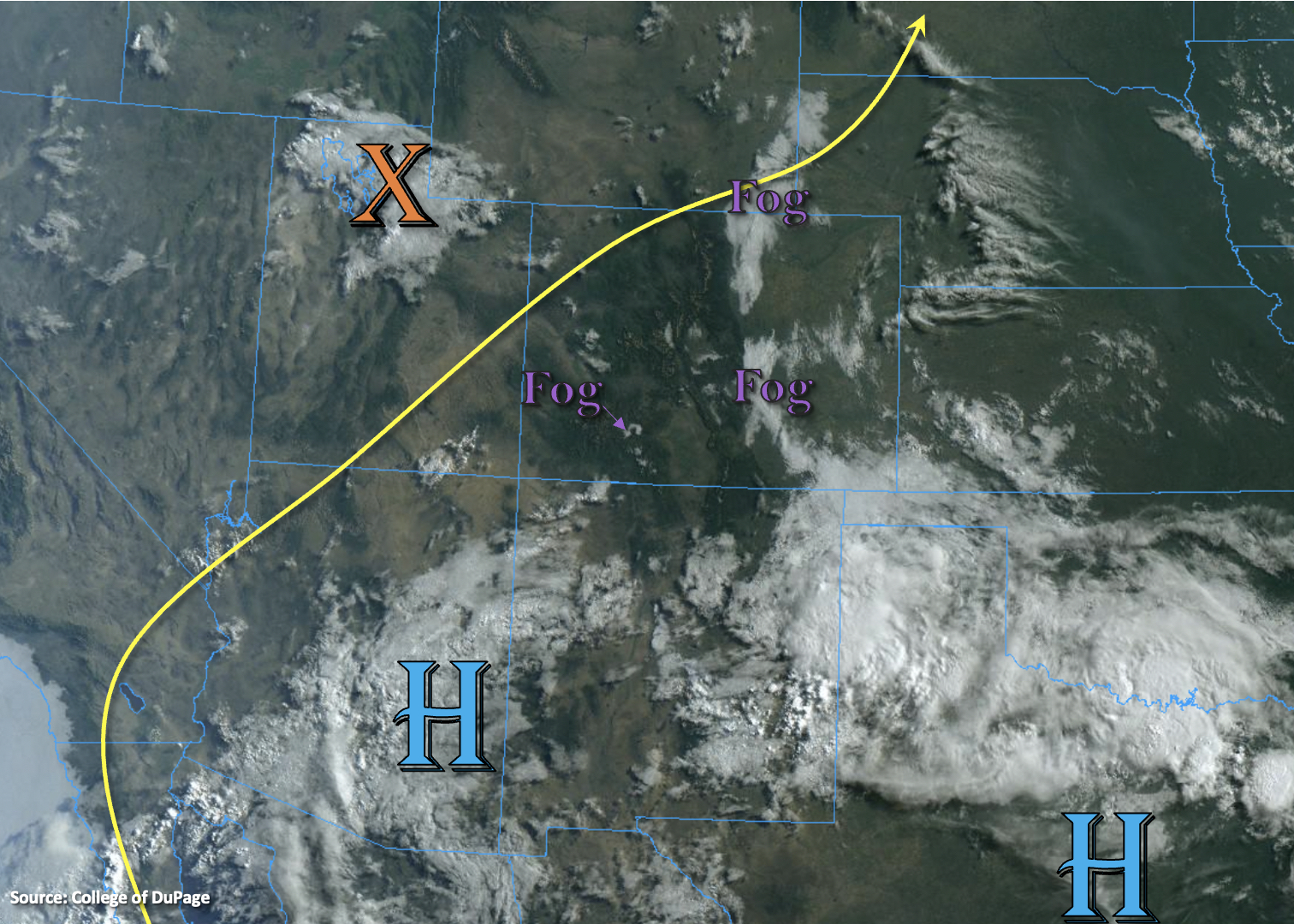
The visible satellite imagery below is showing pockets of fog and cloud cover across the eastern plains and in some of the mountain valleys this morning. It is more widespread over the adjacent eastern plains with the dew points in the upper 50Fs to low 60Fs range. The upper Low from yesterday is currently over northern Wyoming, and it will continue to pull northward throughout the day while the High and associated ridge begins to reestablish itself back over the southwest US.

While moisture is about the same over western Colorado (PW at 0.93 inches), it has dropped slightly over eastern Colorado (PW at 0.87 inches). This is still quite elevated, and with lower-end steering flow forecast again under the building ridge, the scattered storms that develop (east) will again be capable of local heavy rainfall this afternoon and evening. Guidance is indicating that the westerly steering flows over eastern Colorado will be slightly higher in magnitude than yesterday. This in tandem with the more scattered nature of the rainfall today, will help to limit the heavy rainfall threat.

There are also no noticeable shortwaves moving through the flow this afternoon, so this will support the heavy downpours to be more scattered in nature. As the west and northwest steering flow drive the storms into the adjacent eastern plains this afternoon, they are expected to have a better chance of producing higher rain rates further south. Outflow boundaries may trigger some additional convection further east, so the Low has been extended due to the elevated moisture in the area.

The mountains, particularly the southern Front Range/northern Southeast Mountains have seen a lot of rainfall over the last 48-hours. Saturated soils and another round of heavy rainfall producing storms this afternoon will increase the runoff, debris flow and local stream flood threat. A Low flood threat has been issued for this reason. Over western Colorado, storm motion will be slightly faster, storm cores a bit smaller, and a larger spread in dew point/temperature will cause rainfall rates to less efficient, so no flood threat has been issued.

Today’s Flood Threat Map

For more information on today’s flood threat, see the map below. If there is a threat, hover over the threat areas for more details, and click on burn areas to learn more about them. For Zone-Specific forecasts, scroll below the threat map.

Zone-Specific Forecasts:

Front Range, Palmer Ridge, Southeast Mountains, Central Mountains, Raton Ridge & Urban Corridor:

Storms are expected to begin by midday again with more scattered coverage than widespread coverage (when compared to yesterday). Over the southern Front Range and Southeast Mountains, max 1-hour rain rates up to 1.10 inches will be possible. Over the northern Front Range and Central Mountains max 1-hour rain rates up to 0.75 inches will be possible. Over the adjacent plains, max 1-hr rain rates up to 1.50 inches (north) and 1.75 inches (south) will be possible. A Low Flood threat has been issued. Flood threats over the steeper terrains include excess runoff into local streams, mud flows and debris slides. Over the adjacent plains, road, local stream, and field ponding will be possible. The heavy rainfall threat is expected to end soon after sundown.

Primetime: Noon to 10PM

Northeast Plains & Southeast Plains: 

No rainfall is anticipated for the far eastern plains today, but a couple outflow boundaries back to the west could trigger some storms over these regions late this afternoon and evening. Max 1-hour rain rates up to 1.75 inches would be possible with slightly higher storm totals further south. A Low flood threat has been issued for road, field and local stream flooding.

Primetime: 4:30PM to 11PM

Northern Mountains, San Luis Valley, San Juan Mountains, Grand Valley, Northwest Slope & Southwest Slope:

Scattered storms will develop over the elevated plateaus and mountains this afternoon with best coverage anticipated closer the Continental Divide. Max 1-hour rain rates up to 0.50 inches (south) and 0.30 inches (north) will be possible. Flooding is NOT expected today.

Primetime: Noon to 9PM

FTB 07-01-2021: High Flood Threat Issued for Portions of Eastern Colorado

Issue Date: Thursday, July 1st, 2021
Issue Time: 10:45AM MDT

— A HIGH flood threat has been issued for Urban Corridor, Palmer Ridge, eastern Raton Ridge and Southeast Plains
MODERATE flood threat has been issued for the Front Range, Northeast Plains, Southeast Mountains

A HIGH flood threat has been issued today due to the widespread, heavy rainfall anticipated this afternoon and tonight. This event will be especially dangerous over urban areas where there is an increase in impervious area. The threat continues into the overnight hours for the Palmer Ridge.

Not much change to the large scale pattern from yesterday with the Low and High creating southwesterly and westerly flow aloft across the state. There has been a slight increase in moisture over western Colorado, and a larger bump in moisture to the east. PW this morning was measured at 0.95 inches and 1.01 inches at Grand Junction and Denver, respectively. So, the atmosphere remains primed for heavy downpours again this afternoon and evening, especially over the Southeast Plains where PW is just over 1.50 inches. Over western Colorado, there are a few lingering showers over the Grand Valley and better clearing over the northern portion of the region and the San Juan Mountains. These clear areas should be the focus areas for the more intense rainfall this afternoon (higher instability), particularly north, where mid-level energy will increase as the Low moves towards the northeast throughout the day.

Slower storm motions are forecast east again, which will be a contributing factor to higher accumulations. Training storms over the Urban Corridor are also expected help increase the 24-hour totals. As storms develop by early afternoon over the Front Range, Southeast Mountains and elevated ridges, initial storm motion will be to the east before the steering flows become more southerly this evening and overnight. A better upslope flow regime is forecast this afternoon and outflow boundaries from ongoing storms will likely trigger additional, more widespread convection today across the adjacent plains. Thus, widespread, heavy rainfall is forecast, and a HIGH flood threat has been issued. Storms are also expected to intensify as they move east, and a couple low-end severe storms may be possible over the adjacent and far eastern plains.

Heavy local downpours are expected to cause flooding issues this afternoon and evening, especially over urban areas with more impervious surfaces. Flood threats include road/intersection flooding, local stream/creek flooding and flooding of low-lying areas. Over the steeper terrains, the threat will elevated again for mud flows and debris slides, especially over recent burn areas. Head over to the Fire Burn Forecast (top of the page) for the latest on burn area threats issued today.

Today’s Flood Threat Map

For more information on today’s flood threat, see the map below. If there is a threat, hover over the threat areas for more details, and click on burn areas to learn more about them. For Zone-Specific forecasts, scroll below the threat map.

Zone-Specific Forecasts: 

Front Range, Palmer Ridge, Southeast Mountains, Raton Ridge & Urban Corridor:

Storms are expected to begin by midday and early afternoon over the mountains and ridges and with more coverage when compared to yesterday. Over the mountains, max 1-hour rain rates up to 1 inch (north) and 0.75 inches (south) will be possible. Over the adjacent plains, max 1-hr rain rates up to 1.90 inches and isolated storm totals between 2.50 and 3 inches will be possible. A Moderate/High Flood threat has been issued. Road, intersection, and local stream flooding will be issues over the more urban areas, and mud flows/debris slides will be possible over the mountains. Heavy rainfall and flooding issues may continue into the overnight hours along the Palmer Ridge due to slow southerly steering flows of storms.

Primetime: Noon to 1AM

Northeast Plains & Southeast Plains: 

Better coverage of storms is expected over the Southeast Plains, and the best chance for rainfall over the Northeast Plains will be west and near the Cheyenne Ridge. Outflow boundaries could trigger a couple isolated storms further east (north). Max 1-hour rain rates up to 3.5 inches (southeast) and 2.25 inches (north) will be possible. This would could cause road, local stream, arroyo and low-lying area flooding.

Primetime: 3PM to Midnight

Northern Mountains, San Luis Valley, San Juan Mountains, Central Mountains, Grand Valley, Northwest Slope & Southwest Slope:

Best coverage of scattered storms this afternoon will be over the San Juan Mountains, Northwest Slope and Northern Mountains. Max 1-hour rain rates up to 0.50 inches (mountains) will be possible with isolated storm totals around 0.75 inches from the smaller storm cores. Over the elevated regions of the Northwest Slope and northern Grand Valley, max 1-hour rain rates up to 0.25 inches will be possible. Flooding is NOT expected today.

Primetime: Noon to 10PM

FTB 06-30-2021: Flood Threat Returns with a Moderate Threat Issued Due to Slow Storm Motion

Issue Date: Wednesday, June 30th, 2021
Issue Time: 10AM MDT

MODERATE flood threat has been issued for the Front Range, Urban Corridor and Palmer Ridge
LOW flood threat has been issued for the Northwest Slope, Southwest Slope, San Juan Mountains, Central Mountains, Northern Mountains and portions of the Southeast Mountains, Northeast Plains and Southeast Plains

We’ll be rounding out the month of June with another flood threat being issued. Below in the visible satellite imagery there are two distinct plumes of moisture over the state. The first is over western Colorado, which is producing light showers this morning over the Grand Valley and Northwest Slope. PW was measured at 0.92 inches this morning in the Grand Junction sounding, which is just above the 90th percentile for this time of year. Even though there will still be a decent dew point depression (spread between temperature and dew point), rainfall rates are expected to become more efficient when compared to yesterday. This should cause scattered storms that develop in the pockets of moderate CAPE to produce local, heavy rainfall once again.

The other PW plume is over eastern Colorado, which is a subtropical jet being rotated around the High located in northeastern Oklahoma. PW over Denver has risen to 0.78 inches, and it increases quickly to over an inch (up to 1.50 inches) as you move more into the eastern plains and into the plume. SSE surface winds will help to keep this moisture banked up against the Palmer Ridge where better instability can develop. Downsloping winds over the northern Urban Corridor are expected to produce lower rainfall rates for storms that move into this northern region.

There are a few factors that are contributing to the elevated flood threat today, which will help produce local, heavy rainfall. The first is the presence of moisture, which was already discussed above. The second are some mid and upper-level dynamics helping to increase lift over the area. The subtropical jet may help some additional storms kick off over the eastern plains very late tonight/early tomorrow morning, which is why the Low threat has been extended east. Lastly, storm motion is expected to be very slow, especially over the Moderate flood threat area. This will allow for some very heavy accumulations in the storm cores that develop. Therefore, a Low/Moderate flood threat has been issued today. Over the steeper terrains, mud flows, debris slides and local stream/creek flooding could become an issue. Over the adjacent plains, field ponding, flooding of low-lying areas and road/intersection flooding will be the primary threats. Scroll below for more details about the rainfall rates in each zone.

Today’s Flood Threat Map

For more information on today’s flood threat, see the map below. If there is a threat, hover over the threat areas for more details, and click on burn areas to learn more about them. For Zone-Specific forecasts, scroll below the threat map.

Zone-Specific Forecasts:

Front Range, Palmer Ridge & Urban Corridor:

Slow steering flows may produce max 1-hour rain rates up to 1.75 inches (adjacent plains) and 1.50 inches (mountains). Isolated storm totals up to 2.25 inches are possible. This could cause road and local creek/stream flooding as well as mud flows and debris slides over steeper terrains. A Moderate flood threat has been issued, and storms that develop over the Palmer Ridge are forecast to continue into tonight.

Primetime: 1:30PM to 1AM

Southeast Mountains, San Luis Valley, Raton Ridge, Northeast Plains & Southeast Plains: 

Cloud cover and ongoing showers will limit instability and produce lower rainfall rates over the Southeast Mountains (south) and Raton Ridge. Max 1-hour rain rates up to 0.50 inches (east) and 0.30 inches (west) will be possible with a second round of showers this afternoon and evening. Over the northern Southeast Mountains and Wet Mountains, if instability can build throughout the day, max 1-hour rain rates up to 0.75 inches will be possible. A Low flood threat has been issues for this area.

Over the eastern plains, a couple stronger storms may develop late tonight/early tomorrow morning. While more isolated in nature, max 1-hour rain rates up to 1.75 inches may be possible. This could cause field ponding and road flooding near the storm cores, so the Low flood threat has been extended eastward.

Primetime: 1:30PM to Ongoing

Northern Mountains, San Juan Mountains, Central Mountains, Grand Valley, Northwest Slope & Southwest Slope:

One limiting factor this afternoon for storm development will be lower instability due to the ongoing cloud cover. However, pockets of instability should still be able to form under the summer sun, which will produce scattered, weak thunderstorms and showers in an elevated moisture environment. In the pockets of higher instability, max 1-hour rain rates up to 0.75 inches with isolated storm totals up to 1 inch will be possible with the training and stationary storms. This may create road flooding and mud flows/debris slides over steeper terrains. A Low flood threat has been issued.

Primetime: 1PM to 10PM

FTB 06-29-2021: Monsoonal Moisture To Brush Southwest Colorado

Issue Date: Tuesday, June 29th, 2021
Issue Time: 9:45AM MDT

— A LOW flood threat has been posted for parts of the San Juan Mountains, Central Mountains, Southwest Slope and Grand Valley

A plume of monsoonal moisture will advect into southwest Colorado later this afternoon, providing beneficial rainfall to the drought-stricken region. As shown in the visible satellite image, below, the main wildcard will be the degree to which sunshine can boost instability. Pockets of clear skies over the San Juan Mountains this morning indicate that sufficient instability will develop to boost instability (CAPE) to as high as 1,000 J/kg locally. PW at Grand Junction has increased notably from 0.64 to 0.79 inches today. Although boundary layer moisture is limited at Grand Junction, a much moister boundary layer was noted from the Albuquerque, NM sounding with a PW of 1.03 inches. Numerous to widespread showers and thunderstorms are expected over southwest Colorado later this afternoon, warranting a Low flood threat. Where instability is limited, max 3-hour rainfall could still approach 1.6 inches. On the other hand, for regions with higher instability, max 1-hour rainfall up to 1.1 inches will be possible. In either situation, a Low flood threat is appropriate for the threat of isolated flash flooding, debris slides and mud flows, especially over steeper terrain.

East of the Continental Divide, some warming aloft will limit instability this afternoon. However, with marginal moisture still in place, isolated to scattered thunderstorms will once again be possible especially over the higher terrain. However, flooding is not expected for these areas.

Today’s Flood Threat Map

For more information on today’s flood threat, see the map below. If there is a threat, hover over the threat areas for more details, and click on burn areas to learn more about them. For Zone-Specific forecasts, scroll below the threat map.

Zone-Specific Forecasts:

San Juan Mountains, Central Mountain, Grand Valley, Southwest Slope and San Luis Valley:

Mostly cloudy with numerous to widespread showers and thunderstorms this afternoon and into late evening. Coverage will be highest of the higher terrain, but even valleys will see measurable rainfall. Max 30-minute rainfall up to 0.7 inches, max 1-hour rainfall up to 1.1 inches and max 3-hour rainfall up to 1.6 inches will be possible, warranting a Low flood threat for parts of the region. Coverage will gradually subside after sunset but isolated heavy rainfall could continue until midnight.

Primetime: 11:30AM through 12AM

Southeast Mountains, Front Range, Urban Corridor, Raton Ridge, Palmer Ridge, Northeast Plains & Southeast Plains:

Isolated to scattered showers and thunderstorms, mainly limited to the higher terrain and adjacent foothills. Max 30-minute rainfall up to 0.5 inches and max 1-hour rainfall up to 0.8 inches especially over northern areas. Over southern areas, a lighter, more stratiform rainfall is expected. Flooding is NOT expected today, but nuisance urban street ponding is possible under stronger storm cores.

Primetime: 12PM through 9PM

Northern Mountains, Northwest Slope:

Isolated to widely scattered showers and thunderstorms possible this afternoon and into evening. Max 1-hour rainfall up to 0.5 inches. Flooding is NOT expected today.

Primetime: 12PM through 8PM