Issue Date: Wednesday, June 30th, 2021
Issue Time: 10AM MDT
— A MODERATE flood threat has been issued for the Front Range, Urban Corridor and Palmer Ridge
— A LOW flood threat has been issued for the Northwest Slope, Southwest Slope, San Juan Mountains, Central Mountains, Northern Mountains and portions of the Southeast Mountains, Northeast Plains and Southeast Plains
We’ll be rounding out the month of June with another flood threat being issued. Below in the visible satellite imagery there are two distinct plumes of moisture over the state. The first is over western Colorado, which is producing light showers this morning over the Grand Valley and Northwest Slope. PW was measured at 0.92 inches this morning in the Grand Junction sounding, which is just above the 90th percentile for this time of year. Even though there will still be a decent dew point depression (spread between temperature and dew point), rainfall rates are expected to become more efficient when compared to yesterday. This should cause scattered storms that develop in the pockets of moderate CAPE to produce local, heavy rainfall once again.
The other PW plume is over eastern Colorado, which is a subtropical jet being rotated around the High located in northeastern Oklahoma. PW over Denver has risen to 0.78 inches, and it increases quickly to over an inch (up to 1.50 inches) as you move more into the eastern plains and into the plume. SSE surface winds will help to keep this moisture banked up against the Palmer Ridge where better instability can develop. Downsloping winds over the northern Urban Corridor are expected to produce lower rainfall rates for storms that move into this northern region.
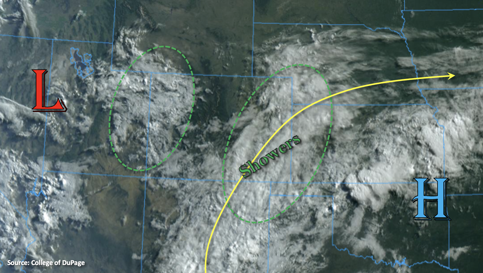
There are a few factors that are contributing to the elevated flood threat today, which will help produce local, heavy rainfall. The first is the presence of moisture, which was already discussed above. The second are some mid and upper-level dynamics helping to increase lift over the area. The subtropical jet may help some additional storms kick off over the eastern plains very late tonight/early tomorrow morning, which is why the Low threat has been extended east. Lastly, storm motion is expected to be very slow, especially over the Moderate flood threat area. This will allow for some very heavy accumulations in the storm cores that develop. Therefore, a Low/Moderate flood threat has been issued today. Over the steeper terrains, mud flows, debris slides and local stream/creek flooding could become an issue. Over the adjacent plains, field ponding, flooding of low-lying areas and road/intersection flooding will be the primary threats. Scroll below for more details about the rainfall rates in each zone.
Today’s Flood Threat Map
For more information on today’s flood threat, see the map below. If there is a threat, hover over the threat areas for more details, and click on burn areas to learn more about them. For Zone-Specific forecasts, scroll below the threat map.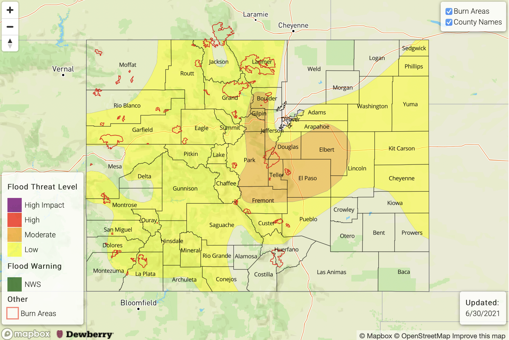
Zone-Specific Forecasts:
Front Range, Palmer Ridge & Urban Corridor:
Slow steering flows may produce max 1-hour rain rates up to 1.75 inches (adjacent plains) and 1.50 inches (mountains). Isolated storm totals up to 2.25 inches are possible. This could cause road and local creek/stream flooding as well as mud flows and debris slides over steeper terrains. A Moderate flood threat has been issued, and storms that develop over the Palmer Ridge are forecast to continue into tonight.
Primetime: 1:30PM to 1AM
Southeast Mountains, San Luis Valley, Raton Ridge, Northeast Plains & Southeast Plains:
Cloud cover and ongoing showers will limit instability and produce lower rainfall rates over the Southeast Mountains (south) and Raton Ridge. Max 1-hour rain rates up to 0.50 inches (east) and 0.30 inches (west) will be possible with a second round of showers this afternoon and evening. Over the northern Southeast Mountains and Wet Mountains, if instability can build throughout the day, max 1-hour rain rates up to 0.75 inches will be possible. A Low flood threat has been issues for this area.
Over the eastern plains, a couple stronger storms may develop late tonight/early tomorrow morning. While more isolated in nature, max 1-hour rain rates up to 1.75 inches may be possible. This could cause field ponding and road flooding near the storm cores, so the Low flood threat has been extended eastward.
Primetime: 1:30PM to Ongoing
Northern Mountains, San Juan Mountains, Central Mountains, Grand Valley, Northwest Slope & Southwest Slope:
One limiting factor this afternoon for storm development will be lower instability due to the ongoing cloud cover. However, pockets of instability should still be able to form under the summer sun, which will produce scattered, weak thunderstorms and showers in an elevated moisture environment. In the pockets of higher instability, max 1-hour rain rates up to 0.75 inches with isolated storm totals up to 1 inch will be possible with the training and stationary storms. This may create road flooding and mud flows/debris slides over steeper terrains. A Low flood threat has been issued.
Primetime: 1PM to 10PM