Issue Date: Thursday, July 1st, 2021
Issue Time: 10:45AM MDT
— A HIGH flood threat has been issued for Urban Corridor, Palmer Ridge, eastern Raton Ridge and Southeast Plains
— A MODERATE flood threat has been issued for the Front Range, Northeast Plains, Southeast Mountains
A HIGH flood threat has been issued today due to the widespread, heavy rainfall anticipated this afternoon and tonight. This event will be especially dangerous over urban areas where there is an increase in impervious area. The threat continues into the overnight hours for the Palmer Ridge.
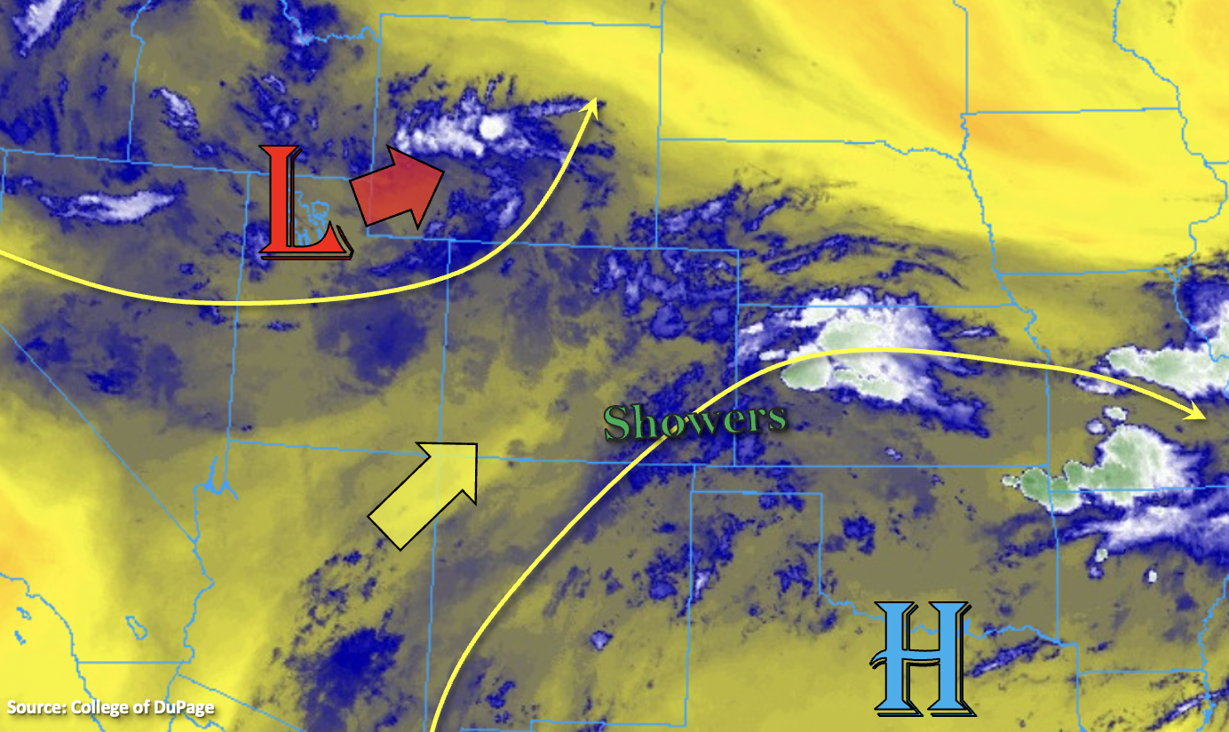
Not much change to the large scale pattern from yesterday with the Low and High creating southwesterly and westerly flow aloft across the state. There has been a slight increase in moisture over western Colorado, and a larger bump in moisture to the east. PW this morning was measured at 0.95 inches and 1.01 inches at Grand Junction and Denver, respectively. So, the atmosphere remains primed for heavy downpours again this afternoon and evening, especially over the Southeast Plains where PW is just over 1.50 inches. Over western Colorado, there are a few lingering showers over the Grand Valley and better clearing over the northern portion of the region and the San Juan Mountains. These clear areas should be the focus areas for the more intense rainfall this afternoon (higher instability), particularly north, where mid-level energy will increase as the Low moves towards the northeast throughout the day.
Slower storm motions are forecast east again, which will be a contributing factor to higher accumulations. Training storms over the Urban Corridor are also expected help increase the 24-hour totals. As storms develop by early afternoon over the Front Range, Southeast Mountains and elevated ridges, initial storm motion will be to the east before the steering flows become more southerly this evening and overnight. A better upslope flow regime is forecast this afternoon and outflow boundaries from ongoing storms will likely trigger additional, more widespread convection today across the adjacent plains. Thus, widespread, heavy rainfall is forecast, and a HIGH flood threat has been issued. Storms are also expected to intensify as they move east, and a couple low-end severe storms may be possible over the adjacent and far eastern plains.
Heavy local downpours are expected to cause flooding issues this afternoon and evening, especially over urban areas with more impervious surfaces. Flood threats include road/intersection flooding, local stream/creek flooding and flooding of low-lying areas. Over the steeper terrains, the threat will elevated again for mud flows and debris slides, especially over recent burn areas. Head over to the Fire Burn Forecast (top of the page) for the latest on burn area threats issued today.
Today’s Flood Threat Map
For more information on today’s flood threat, see the map below. If there is a threat, hover over the threat areas for more details, and click on burn areas to learn more about them. For Zone-Specific forecasts, scroll below the threat map.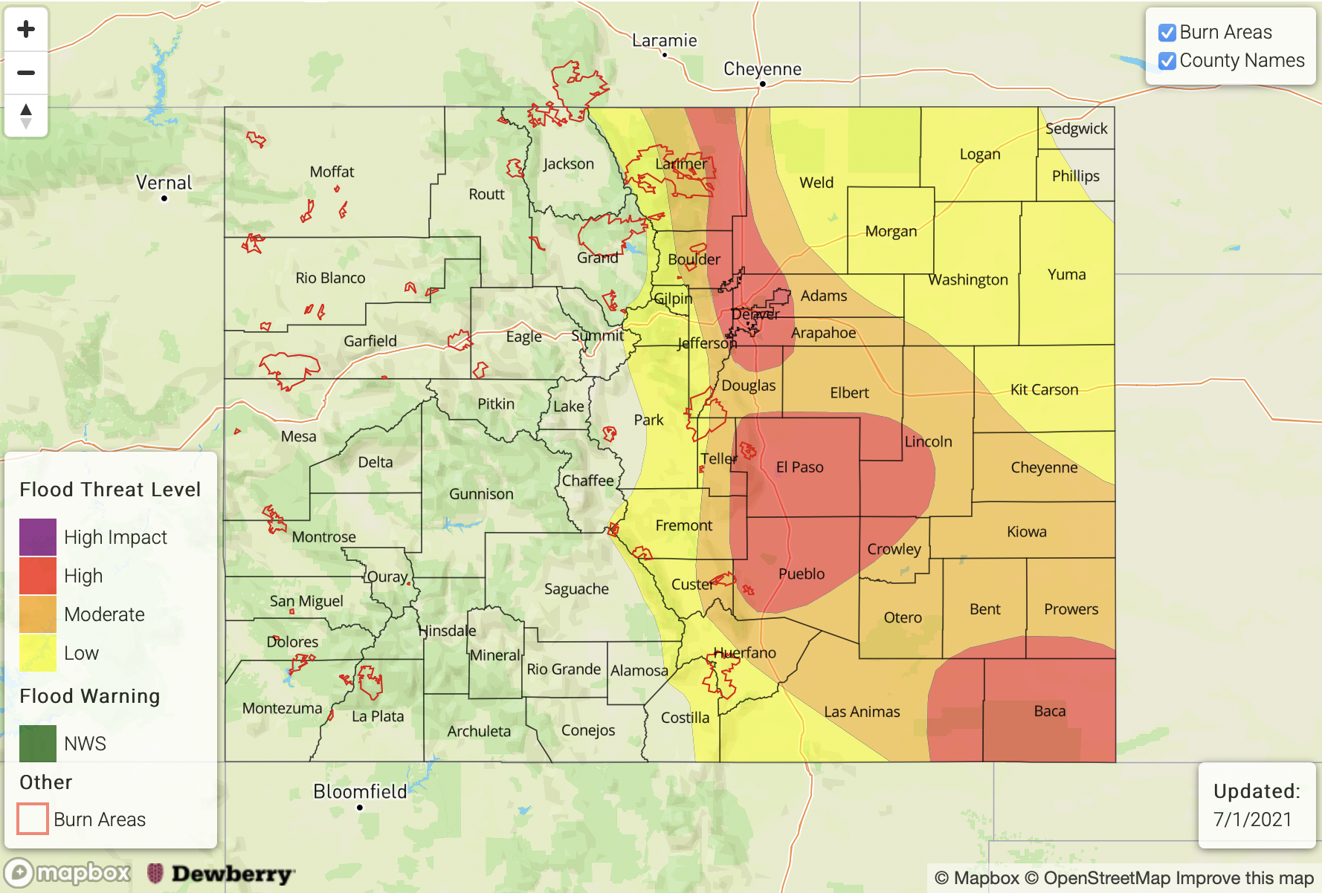
Zone-Specific Forecasts:
Front Range, Palmer Ridge, Southeast Mountains, Raton Ridge & Urban Corridor:
Storms are expected to begin by midday and early afternoon over the mountains and ridges and with more coverage when compared to yesterday. Over the mountains, max 1-hour rain rates up to 1 inch (north) and 0.75 inches (south) will be possible. Over the adjacent plains, max 1-hr rain rates up to 1.90 inches and isolated storm totals between 2.50 and 3 inches will be possible. A Moderate/High Flood threat has been issued. Road, intersection, and local stream flooding will be issues over the more urban areas, and mud flows/debris slides will be possible over the mountains. Heavy rainfall and flooding issues may continue into the overnight hours along the Palmer Ridge due to slow southerly steering flows of storms.
Primetime: Noon to 1AM
Northeast Plains & Southeast Plains:
Better coverage of storms is expected over the Southeast Plains, and the best chance for rainfall over the Northeast Plains will be west and near the Cheyenne Ridge. Outflow boundaries could trigger a couple isolated storms further east (north). Max 1-hour rain rates up to 3.5 inches (southeast) and 2.25 inches (north) will be possible. This would could cause road, local stream, arroyo and low-lying area flooding.
Primetime: 3PM to Midnight
Northern Mountains, San Luis Valley, San Juan Mountains, Central Mountains, Grand Valley, Northwest Slope & Southwest Slope:
Best coverage of scattered storms this afternoon will be over the San Juan Mountains, Northwest Slope and Northern Mountains. Max 1-hour rain rates up to 0.50 inches (mountains) will be possible with isolated storm totals around 0.75 inches from the smaller storm cores. Over the elevated regions of the Northwest Slope and northern Grand Valley, max 1-hour rain rates up to 0.25 inches will be possible. Flooding is NOT expected today.
Primetime: Noon to 10PM