FTB 09-10-2022: Embedded Storms South; Light Rain East; Pleasant West

Issue Date: Saturday, September 10th, 2022
Issue Time: 8:45AM MDT

— Flooding is NOT expected today

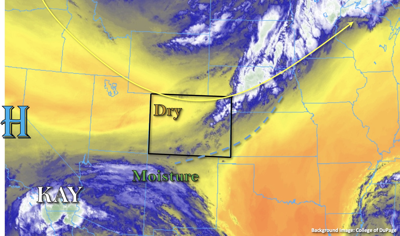
Very active atmospheric dynamics overlie Colorado on this Saturday morning, as a large-scale trough axis is currently directly overhead (see visible satellite image, below). Yesterday’s cool front has easily cleared the entire state, but temperatures have continued to fall under steady northerly cool air advection. Twenty-four hour temperature changes are generally 10-15F statewide, though a few isolated pockets of relatively warmer temperatures remain embedded within the hard-to-reach southern valleys. A very large moisture gradient was observed this morning with Grand Junction’s PW measuring a paltry 0.37 inches while the Platteville research station came in at 0.76 inches. Even higher column moisture exists over southeast Colorado today with PW likely in the 1.0-1.1 inch range over parts of the Southeast Plains. However, total moisture will peak by late morning and begin to decline by later in the afternoon as much drier air infiltrates the entire state from the northwest.

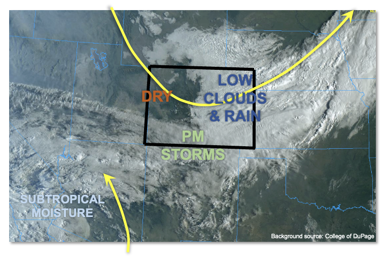
There are two predominant features dictating today’s weather across our state. The primary of the two is a vigorous, large-scale trough that will continue to trek quickly southeastward through the day. With significant mid-level and upper-level (i.e. jet stream) dynamics in support, it will cause synoptic scale lift over southern and eastern Colorado this afternoon. Additionally, a large-scale cloud deck is noted draped east-west along the CO/NM and UT/AZ borders. This is the result of modest mid-level lift courtesy of the subtropical disturbance that was formerly Hurricane Kay. However, this feature will likely be pushed southwestward out of Colorado by early afternoon by the trough.

All in all, we expect mostly cloudy conditions east of the Continental Divide with the ongoing drizzle and light rain showers moving slowly south and east through the afternoon. Meanwhile, pleasant fall weather is expected over most of western Colorado. The only chance of heavy rain today will be in a limited area over the southeast San Juan Mountains, San Luis Valley and perhaps southern fringe of the Southeast Mountains. Instability of up to 1,200 J/kg CAPE should spark a few clusters of storms by mid-afternoon. However, with the increasing S/SE steering flow of 20mph or greater, only brief heavy rainfall is expected along with gusty winds and the threat of hail. Thus, flooding is NOT expected today.

Today’s Flood Threat Map

For more information on today’s flood threat, see the map below. If there is a threat, hover over the threat areas for more details, and click on burn areas to learn more about them. For Zone-Specific forecasts, scroll below the threat map.

Zone-Specific Forecasts:

San Juan Mountains, Southwest Slope, San Luis Valley & Southeast Mountains:

Mostly cloudy skies with an increasing chance of showers and embedded thunderstorms by mid-afternoon. Max 30-min/1-hour rainfall up to 0.8/1.0 inch is possible but only over localized areas. Thus, some ponding of runoff is possible, but flooding is NOT expected today.

Primetime: 3PM through 8PM, with lighter rain possible into the overnight hours

Northeast Plains, Southeast Plains, Front Range, Urban Corridor, Palmer Ridge & Raton Ridge:

Overcast and cool/cold conditions today with drizzle and light rain showers expected through at least the late afternoon. The best chance of precipitation will be over the Northeast Plains as well as the foothills along and west of I-25 from the Denver metro all the way through the NM border. Max 1-hour rain rates up to 0.25 inches with total accumulation up to 0.6 inches possible by Sunday morning.

Primetime: Ongoing through 10PM

Northern Mountains, Central Mountains, Grand Valley & Northwest Slope:

Mostly clear skies with pleasant fall temperature today. Breezy winds of 15-25 mph are expected this afternoon. Flooding is NOT expected today.

FTB 09-09-2022: Cooler Temperatures North & East With Storms Returning To The Southern High Terrain

Issue Date: Friday, September 9th, 2022
Issue Time: 9AM MDT

— Flooding is NOT expected today

Most of the state is waking up to much cooler temperatures this morning thanks to a passing cold front overnight and this morning marked in the water vapor imagery below (blue dashed). With the trough finally breaking up the strong ridge, the state is in for a more active rainfall day. Moisture behind the frontal passage will help to produce some light to moderate rainfall over the Front Range, and additional moisture from the outer bands of Hurricane Kay will help increase moisture across the southern border for widely scattered mountain storms. With westerly winds aloft, precipitation could spill into the adjacent plains with this most likely to occur over the western Raton Ridge.

Taking a closer look at moisture over the state, there looks to be a drier air mass located over northwest Colorado, which is reflected in the 0.53 inch PW value at Grand Junction. PW at Albuquerque was measured at 0.68 inches, so values should increase across the southern border as the outer bands of Kay move northwards today. More importantly, dew points are not overly impressive across the southern border, which means storms are more likely produce strong outflow winds and only moderate rainfall rates. Due to the brief nature of the storms, flooding is NOT expected for the area.

Back over eastern Colorado, PW at Platteville has risen to about 0.75 inches behind the front, which is producing cloud cover over the area. With cooler and more stable conditions forecast for most of the area, rainfall should be confined to the Front Range. Again, surface moisture and instability are lacking, so the brief and isolated storms should produce lighter rainfall totals, so flooding is NOT expected. With a secondary push of colder air late this afternoon and evening, some overnight and early morning rainfall may occur over the Front Range with a dusting of snow possible at the highest peaks.

Today’s Flood Threat Map

For more information on today’s flood threat, see the map below. If there is a threat, hover over the threat areas for more details, and click on burn areas to learn more about them. For Zone-Specific forecasts, scroll below the threat map.

Zone-Specific Forecasts:

Southeast Mountains, San Juan Mountains, Southwest Slope, San Luis Valley & Raton Ridge:

Slightly better moisture both at the surface and upper-levels of the atmosphere is forecast over these zones, which means an uptick in precipitation coverage. Widely scattered storm development is expected by this afternoon over the high terrain. Westerly steering flows may allow for some rain to accumulate over the San Luis Valley and adjacent western Raton Ridge (most likely). Isolated max 30-minute rain rates up to 0.65 inches and local totals around 0.8 inches will be possible. In addition to moderate rainfall rates, more intense storms may produce some lightning and strong outflow winds (up to 45 mph). Flooding is NOT expected. Expected a cool and cloudy start tomorrow morning.

Primetime: 2PM to 11PM

Front Range, Urban Corridor, Palmer Ridge, Northwest Slope, Northern Mountains, Grand Valley, Central Mountains, Northeast Plains & Southeast Plains:

Much cooler start to the day for these zones with the exception of the lower elevations of the Grand Valley. Nonetheless, afternoon high temperatures for the Grand Valley should only reach into the mid-90s °F this afternoon, so still a cool-down when compared to previous days. Outside of the Front Range, these zones should be rain-free today. Some afternoon, post-upslope flow rainfall may be possible over the Front Range and minimal to little spillover is expected over the elevated Palmer Ridge area. A couple stronger rainfall cores may develop (most likely south) where max 30-minute rain rates up to 0.25 inches would be possible. Otherwise, rainfall should be stratiform and light, so flooding is NOT expected. Light precipitation may persist overnight for the Front Range and will likely expand into the Urban Corridor and Northeast Plains by early tomorrow morning. So, it’s going to be a cold, wet and cloudy start to the weekend.

Primetime: 3PM to Ongoing

FTB 09-08-2022: Isolated Showers & Record Heat Possible Again

Issue Date: Thursday, September 8th, 2022
Issue Time: 10:30 AM MDT

— Flooding is NOT expected today

Another day of record-breaking heat is forecast today for much of Colorado, but significant changes in the pattern are underway. The upper-level High center remains relatively stationary over southern Utah continuing to build subsidence overhead this morning. Meanwhile, a powerful upper-level trough will be moving southeastward and into Wyoming by later this afternoon, which will start to create zonal flow across the state. Some mid-level lift out in front of the trough, marked by the “X” in the water vapor image below, is expected to move over Colorado later this afternoon, which will help produce more cloud cover and perhaps a little rainfall. While there has been slight moistening throughout the column west, there has been considerable drying east, as noted by morning PW values of 0.53 and 0.4 inches measured in Grand Junction and Platteville, respectively. Boundary layer moisture continues to be quite meager across the state, so it’s unlikely that much precipitation will reach the ground today despite the increasing upper-level dynamics. The elevated bases of storms and a tightening surface gradient suggest that some gusty winds may also be possible this afternoon. With only brief and isolated rainfall forecast, flooding is NOT expected today.

Today’s Flood Threat Map

For more information on today’s flood threat, see the map below. If there is a threat, hover over the threat areas for more details, and click on burn areas to learn more about them. For Zone-Specific forecasts, scroll below the threat map.

Zone-Specific Forecasts: 

Southwest Slope, San Juan Mountains, San Luis Valley, Grand Valley, Central Mountains, Northern Mountains, & Northwest Slope:

Scattered clouds and light showers are beginning to move across the Northwest Slope and northern border counties this morning. As dynamics increase by later this afternoon, widely scattered cloud cover is expected over the high terrain focused over the Northwest Slope, Central Mountains, San Juan Mountains, and Southwest Slope. Given a very dry boundary layer, elevated storms may produce gusty winds and isolated rainfall. Max 30-to-45-minute rain rates up to 0.4 inches will be possible over the higher elevations of the western San Juan Mountains and eastern Southwest Slope, while the Central Mountains and Northwest Slope may receive totals up to 0.3 inches. Despite the increase in cloud cover, near-daily record high temperatures will be possible across the lower elevations. A cold front is expected to pass through overnight producing gusty winds and dropping high temperatures quite a bit tomorrow. NO flooding is expected today.

Primetime: Ongoing to 10PM

Front Range, Urban Corridor, Northeast Plains, Palmer Ridge, Southeast Mountains, Southeast Plains, & Raton Ridge:

A smoky haze remains present across lower elevations of eastern Colorado this morning, with some cumuli beginning to drift eastward across the northern border counties. This afternoon, temperatures are once again expected to soar upwards to near-record to daily record high temperatures. With a tightening surface gradient, the fire danger will also increase. A Red Flag Warning has been issued for portions of northeast Colorado along with another Heat Advisory for elevations below 6,000 feet. As far as rainfall, isolated storms may drift across the northern border counties from the Front Range eastward under the influence of the upper-level dynamics. However, with a very dry boundary layer, there should be plenty of virga. Isolated max rain rates up to 0.3 inches over a 30-minute period will be possible. Light overnight showers may be possible over the Front Range, and the passing cold front could produce winds gusting up to 40mph east of the Palmer Ridge. This will also produce some cooler temperatures going into tomorrow. Flooding is NOT expected today.

Primetime: 1PM to 2AM

FTB 09-07-2022: Isolated Storms Southwest, Daily Record High Temperatures Possible Statewide

Issue Date: Wednesday, September 7th, 2022
Issue Time: 10:15 AM MDT

— Flooding is NOT expected today

The anomalously strong upper-level high-pressure system now centered over southeastern Utah has strengthened since yesterday. Wildfire smoke will continue to be an issue for air quality over the state today with the highest near-surface smoke concentration expected to remain over northwest Colorado throughout the day. A shortwave located over southeastern Wyoming, marked by the “X” in the water vapor image below, is expected to move southeastward through the flow this afternoon. However, strong subsidence associated with the High has scoured out moisture both through the column and in the boundary layer and should suppress storms and precipitation this afternoon across most of the state despite this extra mid-level lift. This dryness is indicated by morning PW values of 0.42 and 0.51 measured in Grand Junction and Platteville, respectively, along with dew points in the 20s to low 30s°F (west), and 40s°F (east).

This afternoon, even more drying of the boundary layer is expected as temperatures soar to near-record or even daily record highs across the state. A weak moisture pool continues to reside over portions of southwestern Colorado, and instability may reach as high as 800 J/kg over the higher elevations southwest. A few isolated storms will thus be possible over the higher terrain southwest this afternoon, but high dewpoint depressions should yield high-based storms producing mainly virga showers over high elevations of the San Juan Mountains and Southwest Slope this afternoon. A hot, dry, and smoky day is in the cards for the remainder of the state, and NO flooding is expected today.

Today’s Flood Threat Map

For more information on today’s flood threat, see the map below. If there is a threat, hover over the threat areas for more details, and click on burn areas to learn more about them. For Zone-Specific forecasts, scroll below the threat map.

Zone-Specific Forecasts: 

Southwest Slope, San Juan Mountains, San Luis Valley, Grand Valley, Central Mountains, Northern Mountains, & Northwest Slope:

Some isolated cumuli are moving southward along the higher elevations of southwest Colorado this morning, and a smoky haze is noted across western portions of the state. This afternoon, isolated storms will be possible over the southern San Juan Mountains and the higher elevations of the eastern Southwest Slope. These high-based storms should produce primarily gusty winds and lightning. Isolated briefly heavy rainfall with max rain rates of up to 0.4 inches will also be possible with stronger storms over the high terrain of the San Juan Mountains and Southwest Slope. Otherwise, dry conditions and near-record and potentially daily record high temperatures are forecast, and NO flooding is expected today.

Primetime: 3PM to 8PM

Front Range, Urban Corridor, Northeast Plains, Palmer Ridge, Southeast Mountains, Southeast Plains, & Raton Ridge:

Widely scattered early morning clouds over the mountains and portions of the eastern plains are quickly eroding this morning, with smoky skies noted across much of eastern Colorado. This afternoon, a few stray cumuli may drift over the mountains, but precipitation is highly unlikely. Otherwise, hot temperatures approaching or exceeding daily record highs, dry conditions, and smoky haze can be expected across portions of eastern Colorado this afternoon. A Heat Advisory has been issued by NWS Boulder for portions of the Urban Corridor through 6pm this evening for temperatures up to 100 degrees. Please reference NWS Boulder for further details and advisory updates. There is NO flooding expected today.