Issue Date: Wednesday, September 7th, 2022
Issue Time: 10:15 AM MDT
— Flooding is NOT expected today
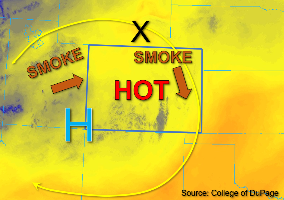
The anomalously strong upper-level high-pressure system now centered over southeastern Utah has strengthened since yesterday. Wildfire smoke will continue to be an issue for air quality over the state today with the highest near-surface smoke concentration expected to remain over northwest Colorado throughout the day. A shortwave located over southeastern Wyoming, marked by the “X” in the water vapor image below, is expected to move southeastward through the flow this afternoon. However, strong subsidence associated with the High has scoured out moisture both through the column and in the boundary layer and should suppress storms and precipitation this afternoon across most of the state despite this extra mid-level lift. This dryness is indicated by morning PW values of 0.42 and 0.51 measured in Grand Junction and Platteville, respectively, along with dew points in the 20s to low 30s°F (west), and 40s°F (east).
This afternoon, even more drying of the boundary layer is expected as temperatures soar to near-record or even daily record highs across the state. A weak moisture pool continues to reside over portions of southwestern Colorado, and instability may reach as high as 800 J/kg over the higher elevations southwest. A few isolated storms will thus be possible over the higher terrain southwest this afternoon, but high dewpoint depressions should yield high-based storms producing mainly virga showers over high elevations of the San Juan Mountains and Southwest Slope this afternoon. A hot, dry, and smoky day is in the cards for the remainder of the state, and NO flooding is expected today.
Today’s Flood Threat Map
For more information on today’s flood threat, see the map below. If there is a threat, hover over the threat areas for more details, and click on burn areas to learn more about them. For Zone-Specific forecasts, scroll below the threat map.

Zone-Specific Forecasts:
Southwest Slope, San Juan Mountains, San Luis Valley, Grand Valley, Central Mountains, Northern Mountains, & Northwest Slope:
Some isolated cumuli are moving southward along the higher elevations of southwest Colorado this morning, and a smoky haze is noted across western portions of the state. This afternoon, isolated storms will be possible over the southern San Juan Mountains and the higher elevations of the eastern Southwest Slope. These high-based storms should produce primarily gusty winds and lightning. Isolated briefly heavy rainfall with max rain rates of up to 0.4 inches will also be possible with stronger storms over the high terrain of the San Juan Mountains and Southwest Slope. Otherwise, dry conditions and near-record and potentially daily record high temperatures are forecast, and NO flooding is expected today.
Primetime: 3PM to 8PM
Front Range, Urban Corridor, Northeast Plains, Palmer Ridge, Southeast Mountains, Southeast Plains, & Raton Ridge:
Widely scattered early morning clouds over the mountains and portions of the eastern plains are quickly eroding this morning, with smoky skies noted across much of eastern Colorado. This afternoon, a few stray cumuli may drift over the mountains, but precipitation is highly unlikely. Otherwise, hot temperatures approaching or exceeding daily record highs, dry conditions, and smoky haze can be expected across portions of eastern Colorado this afternoon. A Heat Advisory has been issued by NWS Boulder for portions of the Urban Corridor through 6pm this evening for temperatures up to 100 degrees. Please reference NWS Boulder for further details and advisory updates. There is NO flooding expected today.