Issue Date: Thursday, September 8th, 2022
Issue Time: 10:30 AM MDT
— Flooding is NOT expected today
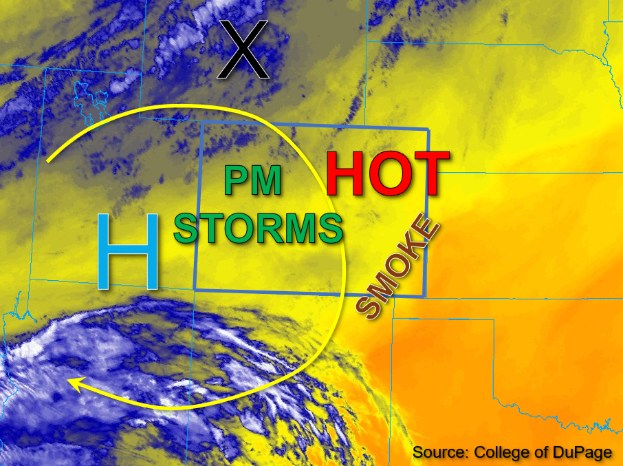
Another day of record-breaking heat is forecast today for much of Colorado, but significant changes in the pattern are underway. The upper-level High center remains relatively stationary over southern Utah continuing to build subsidence overhead this morning. Meanwhile, a powerful upper-level trough will be moving southeastward and into Wyoming by later this afternoon, which will start to create zonal flow across the state. Some mid-level lift out in front of the trough, marked by the “X” in the water vapor image below, is expected to move over Colorado later this afternoon, which will help produce more cloud cover and perhaps a little rainfall. While there has been slight moistening throughout the column west, there has been considerable drying east, as noted by morning PW values of 0.53 and 0.4 inches measured in Grand Junction and Platteville, respectively. Boundary layer moisture continues to be quite meager across the state, so it’s unlikely that much precipitation will reach the ground today despite the increasing upper-level dynamics. The elevated bases of storms and a tightening surface gradient suggest that some gusty winds may also be possible this afternoon. With only brief and isolated rainfall forecast, flooding is NOT expected today.
Today’s Flood Threat Map
For more information on today’s flood threat, see the map below. If there is a threat, hover over the threat areas for more details, and click on burn areas to learn more about them. For Zone-Specific forecasts, scroll below the threat map.

Zone-Specific Forecasts:
Southwest Slope, San Juan Mountains, San Luis Valley, Grand Valley, Central Mountains, Northern Mountains, & Northwest Slope:
Scattered clouds and light showers are beginning to move across the Northwest Slope and northern border counties this morning. As dynamics increase by later this afternoon, widely scattered cloud cover is expected over the high terrain focused over the Northwest Slope, Central Mountains, San Juan Mountains, and Southwest Slope. Given a very dry boundary layer, elevated storms may produce gusty winds and isolated rainfall. Max 30-to-45-minute rain rates up to 0.4 inches will be possible over the higher elevations of the western San Juan Mountains and eastern Southwest Slope, while the Central Mountains and Northwest Slope may receive totals up to 0.3 inches. Despite the increase in cloud cover, near-daily record high temperatures will be possible across the lower elevations. A cold front is expected to pass through overnight producing gusty winds and dropping high temperatures quite a bit tomorrow. NO flooding is expected today.
Primetime: Ongoing to 10PM
Front Range, Urban Corridor, Northeast Plains, Palmer Ridge, Southeast Mountains, Southeast Plains, & Raton Ridge:
A smoky haze remains present across lower elevations of eastern Colorado this morning, with some cumuli beginning to drift eastward across the northern border counties. This afternoon, temperatures are once again expected to soar upwards to near-record to daily record high temperatures. With a tightening surface gradient, the fire danger will also increase. A Red Flag Warning has been issued for portions of northeast Colorado along with another Heat Advisory for elevations below 6,000 feet. As far as rainfall, isolated storms may drift across the northern border counties from the Front Range eastward under the influence of the upper-level dynamics. However, with a very dry boundary layer, there should be plenty of virga. Isolated max rain rates up to 0.3 inches over a 30-minute period will be possible. Light overnight showers may be possible over the Front Range, and the passing cold front could produce winds gusting up to 40mph east of the Palmer Ridge. This will also produce some cooler temperatures going into tomorrow. Flooding is NOT expected today.
Primetime: 1PM to 2AM