Issue Date: Wednesday, July 14th, 2021
Issue Time: 10:15AM MDT
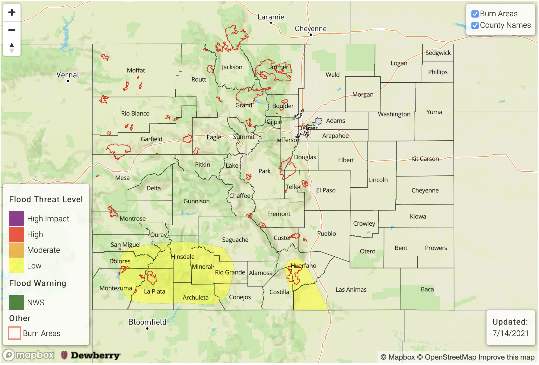
— A MODERATE flood threat has been issued for the Urban Corridor, San Juan Mountains and portions of the Front Range and Palmer Ridge
— A LOW flood threat has been issued for the higher terrains of the Northern Mountains, Northwest Slope, Grand Valley, Southwest Slope and Southeast Mountains. This threat also includes the Raton Ridge, Northeast Plains and Southeast Plains.
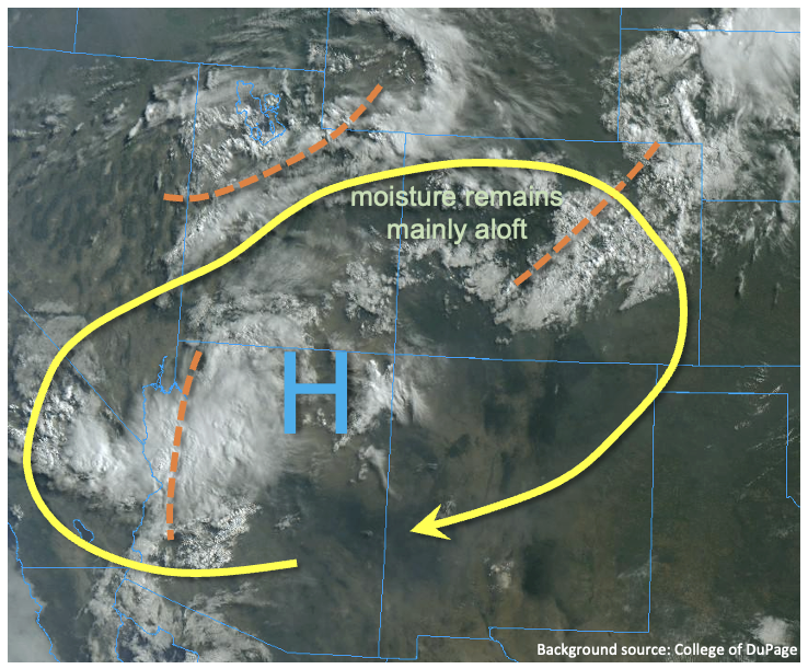
The visible satellite imagery below shows the shortwave from yesterday to our north (orange “X”), which will continue to move to the east throughout today. An associated northerly surge of surface winds has started to move south over the eastern plains this morning, which is expected to increase surface moisture behind it. In addition, a surface Low over the plains today will help to reinforce surface moisture over this area on its east and north sides. Due to the shortwave’s passage, the 500mb High has been pushed south and west, which has allowed for a nice plume of moisture to move northward. Currently over western Colorado, an upper-level disturbance is combining with the moisture plume to produce showers over the southwest corner of the state. Throughout the day, this upper Low is forecast to move eastward and produce extra lift out in front of it. All in all, plenty of moisture and lift over the state for widespread rainfall.
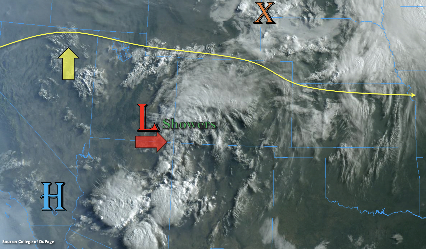
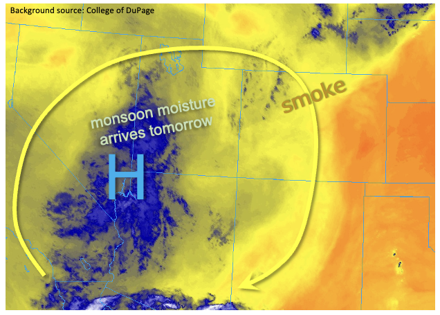
Moisture has already increased quite a bit over western Colorado, and PW at Grand Junction was measured at 1.11 inches. Over Denver, PW remains around 0.80 inches, but is expected to increase to over an inch by later this afternoon. This well above average moisture will set the stage for heavy rainfall producing storms today, so a Moderate/Low flood threat has been issued. As far as the evolution of rainfall development, the ongoing storms over southwest Colorado are expected to increase in intensity with a little daytime heating and spread into the Central Mountains. Training storms will likely produce some higher totals over the southern San Juan Mountains, so a Moderate flood threat has been issued. The eastward movement of the upper-level disturbance will also help to produce widespread storms over the Southeast Mountains by early afternoon. Activity is anticipated to spill into the adjacent plains, and overnight rainfall is forecast for the Southeast Plains. Best chance for heavy rainfall over the plains will occur later this evening along the aforementioned SW to NE oriented boundary from this morning.
In addition to the storms south, numerous storms are expected to develop over the Front Range with post-frontal upslope flow. Decent CAPE is also forecast due to slightly better daytime heating. This means that some stronger thunderstorms may develop as the storms move off the mountains with the northwesterly steering flows. In addition to some hail and strong outflow winds, high surface moisture will allow storms to produce very high rainfall rates. So, a Moderate flood threat has been issued for road, small stream/creek and low-lying area flooding issues over the Urban Corridor and foothills.
Today’s Flood Threat Map
For more information on today’s flood threat, see the map below. If there is a threat, hover over the threat areas for more details, and click on burn areas to learn more about them. For Zone-Specific forecasts, scroll below the threat map.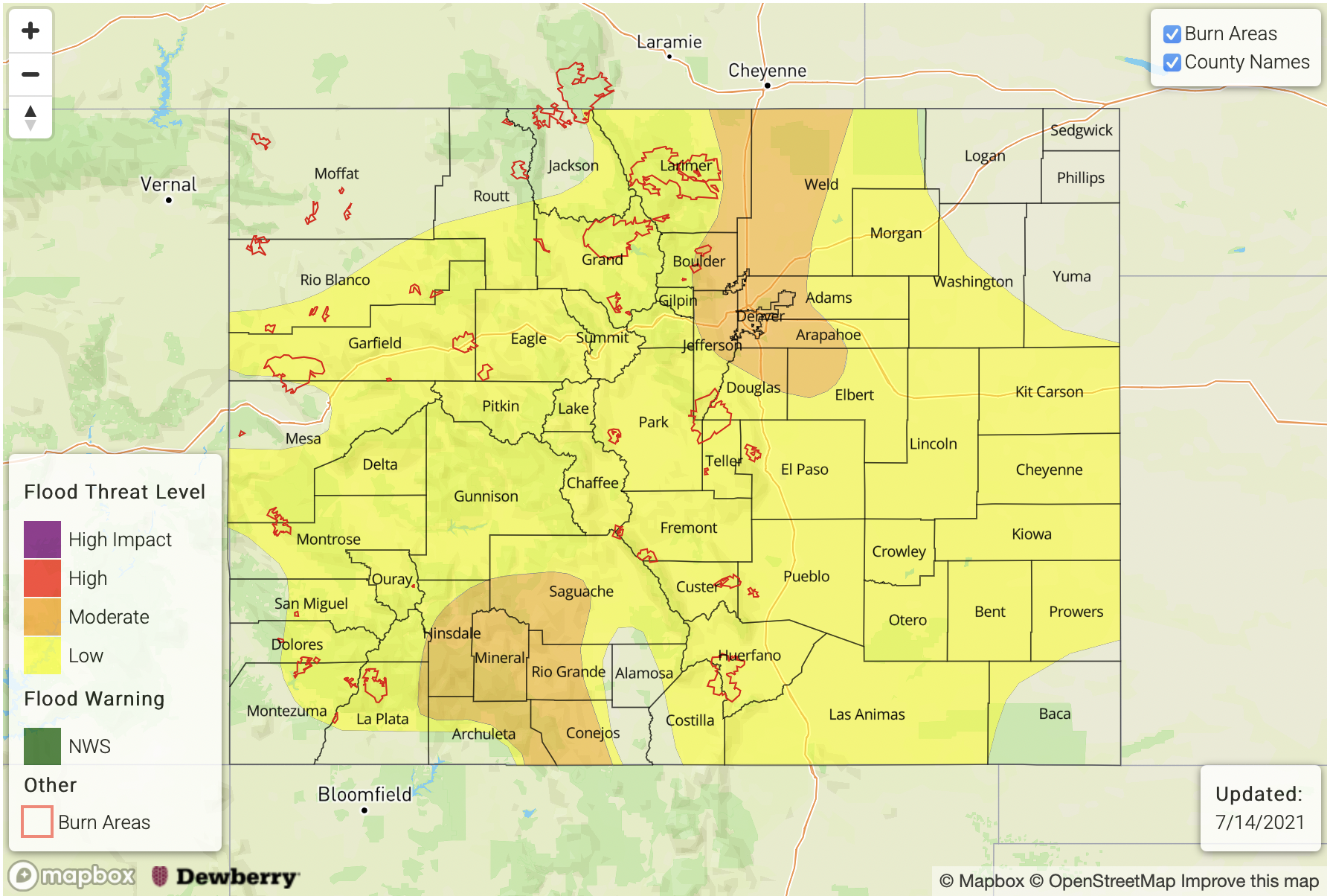
Zone-Specific Forecasts:
Northern Mountains, Grand Valley, Northwest Slope, Southwest Slope, Central Mountains, San Luis Valley & San Juan Mountains:
Storms are anticipated to pick up in intensity and coverage by early afternoon. Best coverage of storms is anticipated over the Central and San Juan Mountains. Max 1-hour rain rates up to 1 inch will be possible with storm totals up to 1.5 inches. A Moderate flood threat has been issued. Further north, better instability may develop, which would allow for some thunderstorm activity later this afternoon. Storm movement will be more northerly during this period as the ridge builds to the west. Max 1-hour rain rates up to 1 inch will be possible with these storms, so a Low flood threat has been issued. Threats today over the steeper terrains include mud flows and debris slides as well as local stream/creek flooding and road flooding.
Primetime: 12PM to 12AM
Front Range, Southeast Mountains, Palmer Ridge, Raton Ridge & Urban Corridor:
Numerous storms are anticipated to develop over the eastern high terrains this afternoon. Max 1-hour rain rates up to 1.25 inches (north) and 1 inch (south) are possible. This could cause mud flows and debris slides as well as road flooding over the steeper terrains. As storms move into the Urban Corridor, max 1-hour rain rates up to 2 inches will be possible, which could cause road, low-lying area and intersection flooding issues. A Moderate flood threat has been issued.
Primetime: 1PM to 11PM
Northeast Plains & Southeast Plains:
As storms move off the mountains and into the plains this afternoon, they will be moving into higher surface moisture. If the storms can make it into the plains before the instability drops off, max 1-hour rain rates up to 2 inches will be possible. Best chance for heavy rainfall will be along the left over cold front boundary that stalls out over the far eastern plains, which could make storms more stationary in nature. These storms may produce road flooding, field ponding and local stream flooding issues. Other threats from storms include hail and damaging outflow winds. Storms will likely linger into the early morning hours over the Southeast Plains, but the flood threat should drop off around midnight. A Low flood threat has been issued.
Primetime: 6PM to Midnight