Issue Date: Sunday, July 11th, 2021
Issue Time: 8AM MDT
— Flooding is NOT expected today
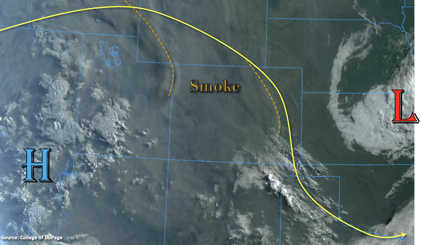
Northerly flow from the combined High/Low pattern aloft pulled in a lot of smoke over state yesterday, which produced a noticeable haze by the afternoon hours. That smoke is still here this morning, and visible satellite (below) shows this feature as a gray hue over the western states. A couple stronger plumes of smoke affecting Colorado are marked by the dashed lines. A rinse and repeat pattern is forecast today for precipitation chances and high temperatures, so another mild weather day is ahead. PW was measured around 0.50 inches both east (DEN) and west (GJT), and a weak moisture plume was noted over the mountains. This minimal moisture paired with larger-scale subsidence, should only allow for a couple isolated, weak storms to develop over the mountains this afternoon and evening. Better concentration of the PW plume is across the southern border, so the southern San Juan and Southeast Mountains have the best shot at seeing some measurable rainfall today. Northerly steering flow should keep the weak storms anchored to the mountains with all rainfall activity ending just after sundown. Flooding is NOT forecast.
Today’s Flood Threat Map
For more information on today’s flood threat, see the map below. If there is a threat, hover over the threat areas for more details, and click on burn areas to learn more about them. For Zone-Specific forecasts, scroll below the threat map.
Zone-Specific Forecasts:
Front Range, Southeast Mountains, Raton Ridge, Northeast Plains, Palmer Ridge, Urban Corridor & Southeast Plains:
Hazy conditions will continue today with the ongoing fire activity. A couple isolated, weak storms are possible over the mountains again this afternoon. Best chance for rainfall will be over the Front Range/Palmer Ridge intersect, Southeast Mountains and southern Raton Ridge. Isolated storm totals up to 0.40 inches (south) will be possible with most storms producing only virga. Brief, localized wind gusts will also be possible over the Southeast Mountains. High temperatures will be a couple degrees warmer than yesterday with upper 80Fs for most of the lower elevations and low to mid-80Fs for the mountain valleys. Flooding is NOT forecast.
Primetime: 1PM to 9PM
Grand Valley, Northwest Slope, Southwest Slope, Central Mountains, San Luis Valley, San Juan Mountains & Northern Mountains:
Near surface smoke is expected to be strongest west of the Continental Divide over these forecast regions. Despite the smoke, high temperatures should still be able to climb in the upper 90Fs and possibly reach 100F (localized) over the lower elevations. Mountain valleys’ high temperatures will reach into the mid-80Fs. Best chance for an isolated, weak storm or two will be over the southern San Juan Mountains and along the Continental Divide over the southern Central Mountains. Max 1-hour rain rates up to 0.60 inches will be possible (south). Plenty of virga is also forecast due to the dry surface layer. Flooding is NOT forecast.
Primetime: 1PM to 9PM