Issue Date: Friday, July 30th, 2021
Issue Time: 10AM MDT
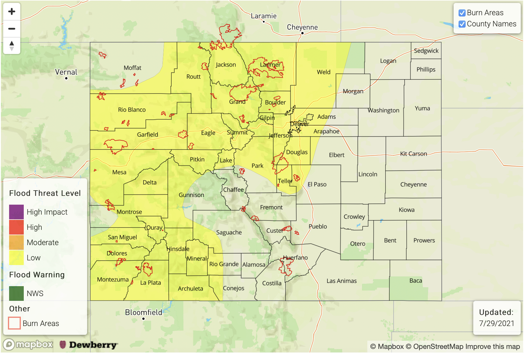
PM Update (3:40PM MDT): There is an increased chance for heavy rainfall producing storms anywhere across the Urban Corridor tonight and into the overnight hours. High dew points, increasing PW and extra convergence paired with slow steering flows will set the stage for the possibility of very high rainfall rates. Storms may be capable of producing road flooding, field ponding, low-lying intersection flooding and local stream/creek/gulch flooding. Therefore, the MODERATE threat has been extended eastward to include all of the Denver Metro area. Localized storm totals up to 2.75 inches possible will still be possible.
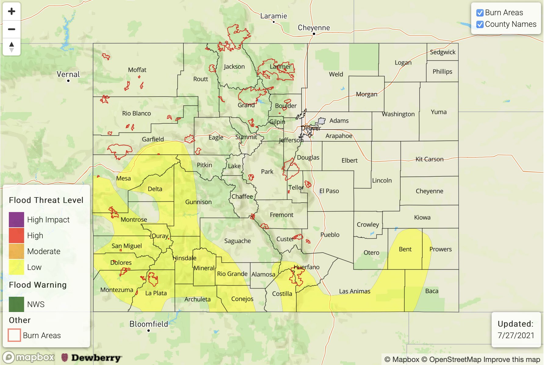
— A MODERATE flood threat has been issued for the Northern Mountains, Central Mountains, and portions of the Northwest Slope, Grand Valley, Southwest Slope, San Juan Mountains, Front Range, Urban Corridor and Northeast Plains
— A LOW flood threat has been issued for the eastern Palmer Ridge, Southeast Mountains and San Luis Valley
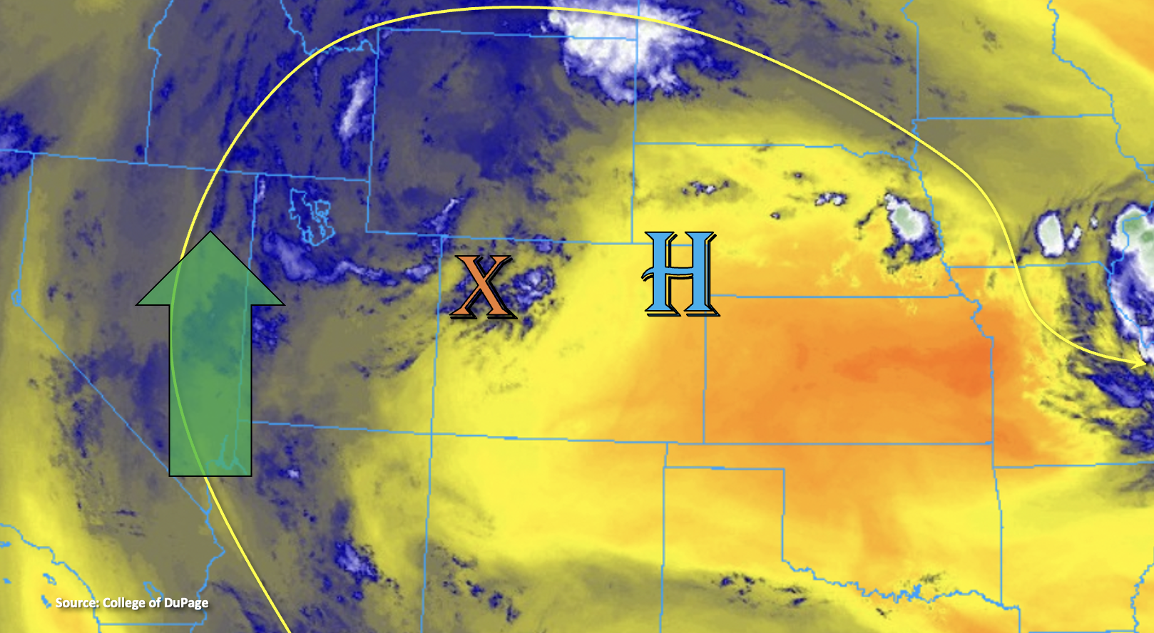
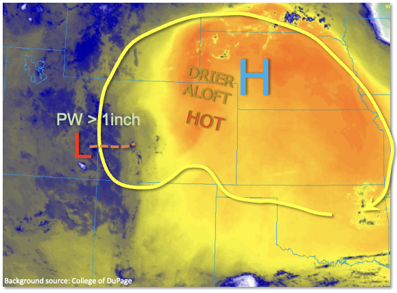
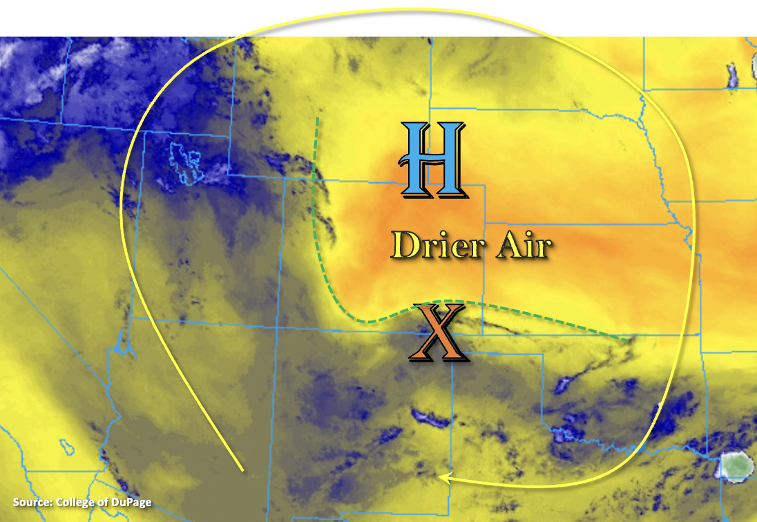
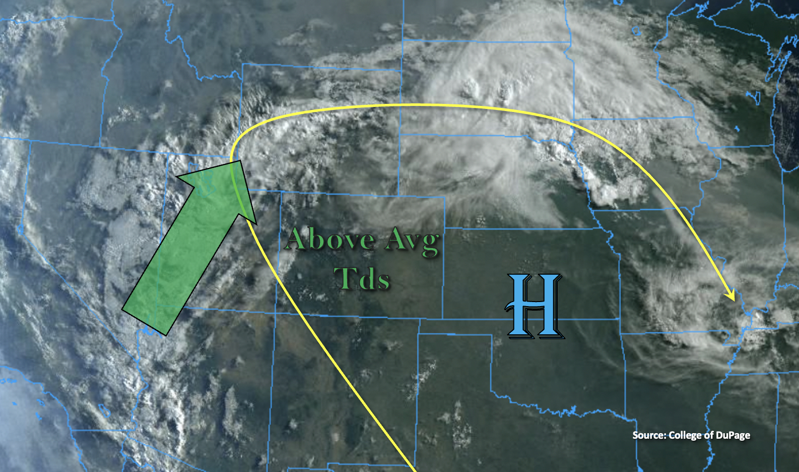
An active rainfall day is ahead with the well-established monsoon surge (green arrow) continuing to rotate sub-tropical moisture around the High. Dew points are quite impressive across the state this morning at 50F+, which should aid in efficient rainfall rates as storms begin to fire over the mountains by early afternoon. PW at Grand Junction has risen to 1.17 inches, nearing the maximum moving average for this time year. While PW to the east, over Denver, was measured at 0.79 inches, it is expected to increase throughout the day to over 1 inch. Storms today will be mostly driven by the diurnal cycle that kicks in by early afternoon, but some weak mid-level lift from embedded shortwaves may help to generate better coverage of thunderstorms across western Colorado with a couple severe thunderstorms possible once again.
There is a much higher chance today that storms will spill into the adjacent eastern plains this evening (Urban Corridor and Northeast Plains). Part of the reason for this is that a cold front is expected to drop south through eastern Colorado around this time. Extra convergence along the front and post-frontal upslope flow will likely keep storms going over the plains and mountains into the overnight hours. Thus, the MODERATE flood threat has been extended into this region as rainfall rates could be very high with the extra convergence and high moisture content. However, over southern Colorado, storms are expected to dissipate a couple hours after sundown as instability decreases and a drier air mass works its way in from the northeast.
As far as the flood threat today, it is widespread and elevated as the storms that develop this afternoon and evening have the potential to produce a lot of rainfall over numerous locations. This is due to the high moisture, slower steering flows and the potential for back-building/training storms. It is also likely that in this moisture-rich environment, outflow boundaries from stronger storms will help to trigger additional storm coverage over the mountains. There is also a threat for riverine flooding today along local creeks and streams, especially around and near recent burn areas. Over steeper terrains, the heavy rainfall has to potential to generate mud flows and debris slides along with road flooding and field ponding possible over the adjacent plains. A large MODERATE threat has been issued for these reasons. Please stay tuned into your local NWS office this afternoon for the latest on real-time warnings that are issued.
Today’s Flood Threat Map
For more information on today’s flood threat, see the map below. If there is a threat, hover over the threat areas for more details, and click on burn areas to learn more about them. For Zone-Specific forecasts, scroll below the threat map.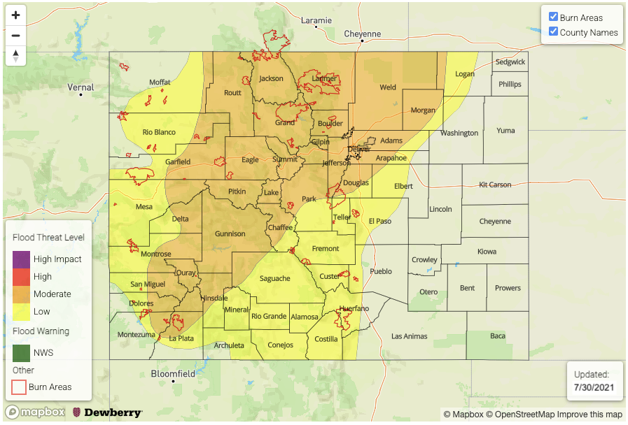
Zone-Specific Forecasts:
Grand Valley, Northern Mountains, Northwest Slope, Central Mountains, Southwest Slope & San Juan Mountains:
Over the mountains, max 1-hour rain rates up to 1.75 inches (north) and 1.50 inches (south) will be possible along with a couple severe thunderstorms. A large swath of 1-inch accumulations are likely by morning over the steeper terrains, and isolated totals just over 2 inches are possible further north. Storms will likely increase in coverage throughout the evening and may last into the overnight hours. The flood threat should end just before 10PM (south) & midnight (north) with some light rainfall lingering into tomorrow morning. A MODERATE/LOW flood threat have been issued.
Primetime: 1PM to 2AM
Front Range, Northeast Plains and Urban Corridor:
Max 1-hour rain rates up to 1.75 inches will be possible over the Front Range this afternoon and evening. Widespread areas over the mountains could receive 1-inch of rainfall, which increases the threat for riverine flooding – especially near recent burn areas. As the front drops south this evening, a couple stronger storms could develop along the area of enhance convergence. Max 1-hour rain rates up to 2.50 inches with totals over 3 inches may be possible over the adjacent plains. Storms should linger into the overnight hours with the flood threat ending just around 1AM. For these reasons, a MODERATE flood threat has been issued
Primetime: 1PM to 2AM
Southeast Mountains, Raton Ridge, San Luis Valley, Palmer Ridge & Southeast Plains:
Storms should stick close to the higher terrains this afternoon and be more isolated in nature. Isolated totals over a 1 to 2 hour period up to 1 inch will be possible, so a LOW flood threat has been issued. The clockwise rotation of the storms could push some action into the San Luis Valley with totals up to 0.60 inches by morning in the interior valley. Impending dry air from the northeast will likely end the rainfall chances by early evening.
Primetime: 1:30PM to 8PM