Issue Date: Wednesday, July 28th, 2021
Issue Time: 10:10AM MDT
— A LOW flood threat has been posted for parts of the Central Mountains, Grand Valley, San Juan Mountains and Southwest Slope
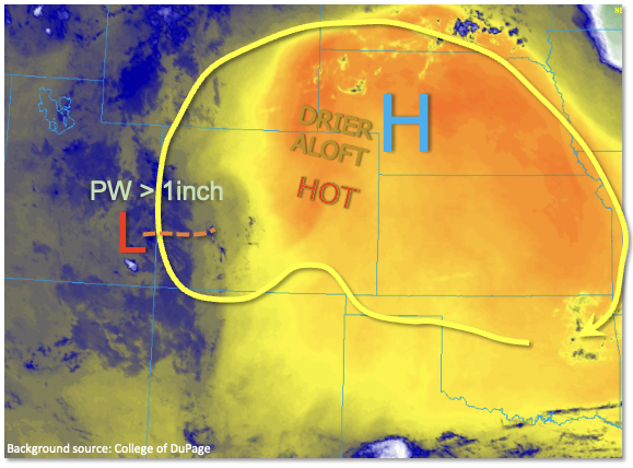
A battle of monsoonal versus dry air continues across Colorado, with the Continental Divide roughly acting as the barrier, as seen in the water vapor image below. To the east, Denver’s morning PW of 0.66 inches is up significantly from yesterday’s 0.47 inches. However, subsidence noted by a distinct warm layer around 500 mb and very dry air aloft will continue to place a lid on storms activity in most areas east of the Continental Divide (with the exception being the Southeast Mountains). To the west is where things get interesting. This morning’s PW at Grand Junction came in at an impressive 1.30 inches, which is close the daily record and also within about 10% of the all-time record value in the 1.45 inch range. PW should stay steady or perhaps slightly decrease as some intrusion of dry air is likely around the very high terrain. However, PW well above 1 inch should persist towards the UT border. Surface moisture was equally impressive with dewpoint temperatures in the low 60s over the lower elevations of the Grand Valley and Southwest Slope. Instability up to 1,500 J/kg is expected for this afternoon, which is on the higher range of typical monsoon activity. Generally southeasterly steering flow of ~15mph should keep storms moving, with enough shear present to support a more organized storm complex or two, just like on Tuesday. A once impressive, but now decaying storm complex was noted in southeast UT this morning, and its circulation could prevent storms due to cloud cover along the UT border itself. However, to the east, this decaying circulation could continue to enhance storm activity over the San Juans, Elk Mountains, Grand Mesa and the Flat Tops. With the aforementioned factors and yesterday’s storm totals on the high side of guidance (see State Precipitation Map discussion), a LOW flood threat continues to be warranted over large parts of the western slope for this afternoon through late evening. There is some inclination to go with a higher threat today, but unfortunately the main hesitation is a lack of confidence for any given location.
Today’s Flood Threat Map
For more information on today’s flood threat, see the map below. If there is a threat, hover over the threat areas for more details, and click on burn areas to learn more about them. For Zone-Specific forecasts, scroll below the threat map.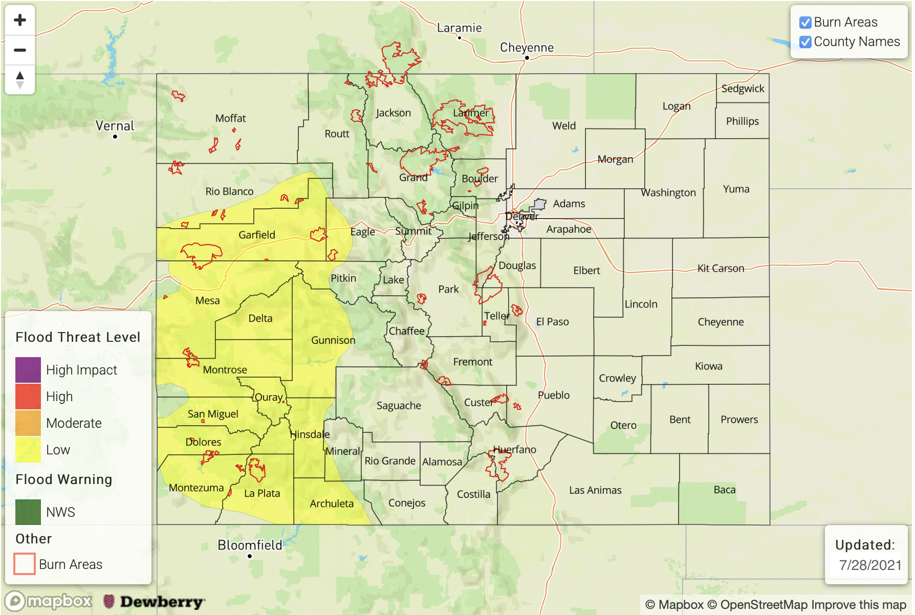
Zone-Specific Forecasts:
San Juan Mountains, Southwest Slope, Grand Valley, Central Mountains, San Luis Valley, Northwest Slope, Northern Mountains and Southeast Mountains:
Numerous showers and thunderstorms today, especially over higher elevations above 8,000 feet. Max 30-minute rainfall up to 0.8 inches, with max 1-hour rainfall up to 1.3 inches. Storm total precipitation up to 2.0 inches possible by tomorrow morning. A LOW flood threat has been posted for parts of the region for isolated flash flooding, debris slides and mud flows. Additionally, some area rivers are beginning to see higher flows from the persistent rainfall. Thus, small creek and tributary flooding is also possible for areas with already saturated soils.
Primetime: 12PM through midnight
San Luis Valley, Urban Corridor, Northeast Plains, Southeast Plains, Palmer Ridge, San Luis Valley, Raton Ridge and Front Range:
Very hot and mostly dry today with an isolated shower or storm possible especially for the higher elevations and foothills. Max 1-hour rainfall up to 0.5 inches. Flooding is NOT expected today. High temperatures are expected to exceed 100F for the lower elevations of the South Platte and Arkansas river valleys.
Primetime: 1PM through 8PM