Issue Date: Thursday, July 29th, 2021
Issue Time: 10:15AM MDT
— A LOW flood threat has been issued for the Northwest Slope, Northern Mountains, Front Range, Grand Valley, Central Mountains, Urban Corridor, Southwest Slope and San Juan Mountains
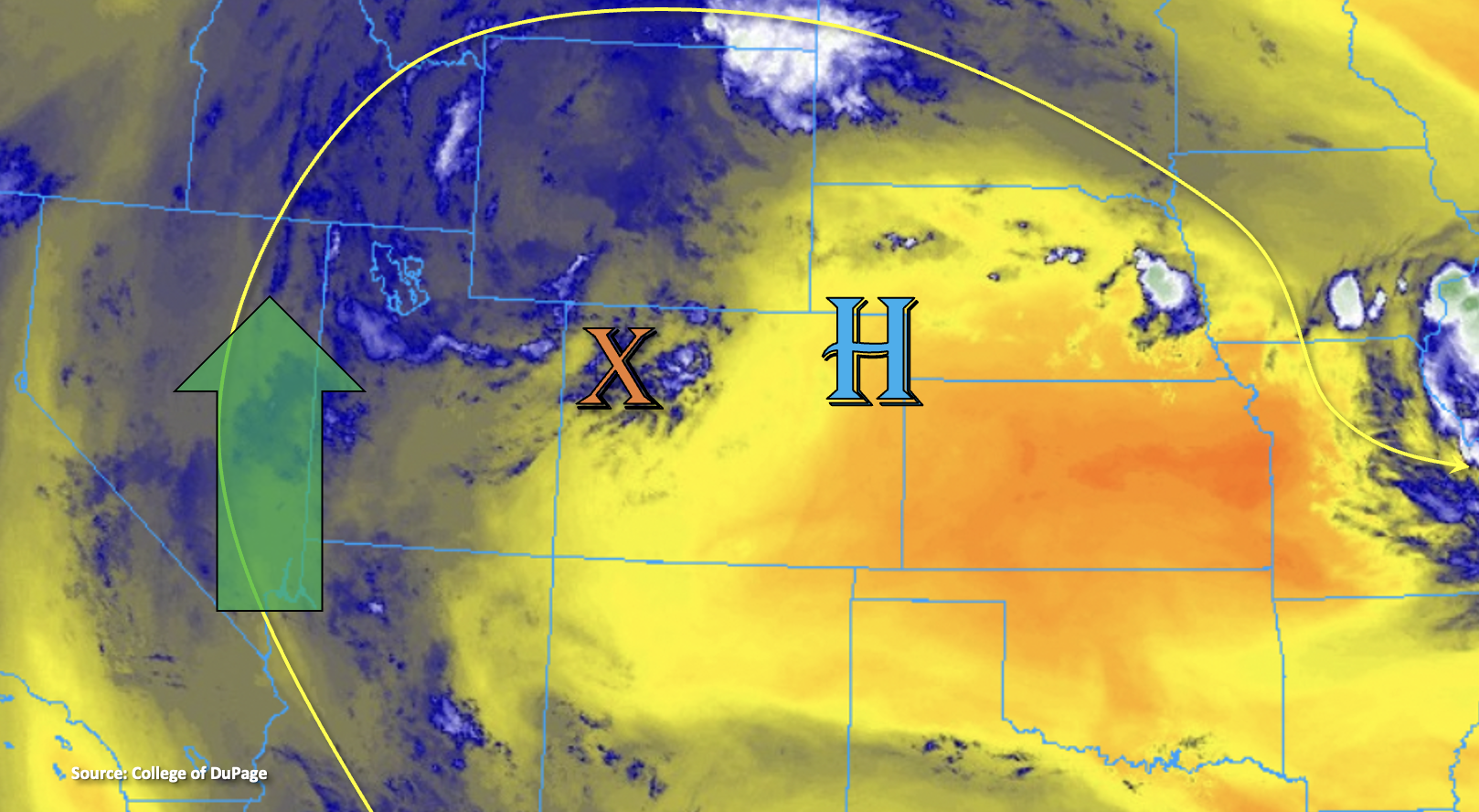
The monsoon moisture surge continues around the High pressure system shown below (green arrow). Within the plume of moisture, PW remains over 1 inch, so it’s a juicy air mass. In this morning’s Grand Junction sounding, PW was measured at 1.08 inches, and it should hover around this above average value throughout the day. Clockwise rotation around the High will pull the plume and mid-level energy noted by the orange “X” below over the northern Front Range by this afternoon. This is expected to return storm chances to the area, and the more westerly steering flows over this region will likely push storms into the Urban Corridor this evening. Storm chances are lower over the adjacent plains due to a cap in place, but a few storms could break the cap along the I-25 corridor. Drier air, marked by the yellow/orange shades below, should help to limit the rainfall potential over the eastern/central mountains south of the Palmer Ridge and over the adjacent ridges and plains. Outside of some weaker and more isolated storms for the Southeast/Central Mountains, southern and eastern Colorado should be dry and hot once again.
Steering flow speed is expected to be comparable to yesterday and training storms are forecast once again, which should let storms today produce higher-end rainfall accumulations that may lead to local flooding issues. Additionally, a couple low-end severe thunderstorms are possible, and these will be most likely over the northern portion of the state where afternoon instability looks to reach 1,500 to 2,500 J/kg. With all the ingredients for heavy rainfall coming together once again, another Low flood threat has been issued over a broad area. While chances for rainfall are lower over the adjacent, eastern plains with the aforementioned cap in place, should a storm or two break the cap, heavy rainfall will be possible. Thus, the Low threat has been extended eastward into the area that this would be most likely to occur.
Today’s Flood Threat Map
For more information on today’s flood threat, see the map below. If there is a threat, hover over the threat areas for more details, and click on burn areas to learn more about them. For Zone-Specific forecasts, scroll below the threat map.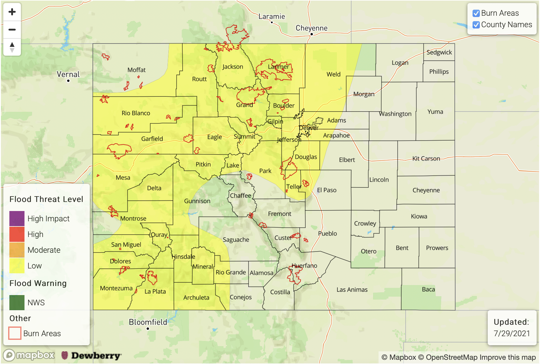
Zone-Specific Forecasts:
Grand Valley, Northwest Slope, Central Mountains, Southwest Slope & San Juan Mountains:
High moisture continues to stream into the area with the clockwise rotation around the High. While heavy rainfall chances aren’t quite as widespread as yesterday, isolated storms over these regions will be capable of producing rainfall rates up to 1.25 inches. Where training storms develop, 24-hour totals up to 2 inches will be possible. Flooding threats this afternoon and evening include mud flows/debris slides, road flooding and local stream flooding, so another LOW flood threat has been issued. A couple severe storms are also possible over the southern San Juan Mountains and further north over the Northwest Slope/Grand Valley with the threats being 1 inch hail and 60 mph gusts. Guidance indicates some stratiform rainfall over the mountains through the overnight hours, although the flood threat drops off a couple hours after sundown.
Primetime: 1:30PM to 2AM
Front Range, Northern Mountains, Palmer Ridge and Urban Corridor:
With the arrival of the plume and some mid-level energy, the flood threat increases across the Front Range and Northern Mountains today. A couple severe storms will also be possible over these forecast regions with decent CAPE and minimal shear intact. Max 1-hour rain rates up to 1.75 inches will be possible with isolated storm totals up to 2.50 inches. Westerly steering flow will push the storms into the adjacent plains this evening and a storm or two may break through the cap. If this occurs, rainfall rates up to 1.25 inches will be possible, which could create road flooding, field ponding and local stream flooding. A LOW flood threat has been issued.
Primetime: 1:30PM to 10:30PM
Southeast Mountains, Raton Ridge, San Luis Valley, Northeast Plains & Southeast Plains:
Isolated, high-based storms will be possible over the Southeast Mountains this afternoon and expect many of the storms to only produce virga. Max 1-hour rain rates up to 0.20 inches are forecast, and the main threat from storms that develop will be brief, gusty outflow winds. With more easterly steering flow around the High, storms may spill into the San Luis Valley. Isolated totals up to 0.15 inches will be possible. The plains should stay dry, and all regions should expect another hot day ahead.
Primetime: 2PM to 8:30PM