FTB 08-11-2021: Isolated Storms Expected Along Southern Border

Issue Date: Wednesday, August 11th, 2021
Issue Time: 8:30PM MDT

— Flooding is NOT expected today

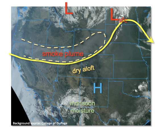
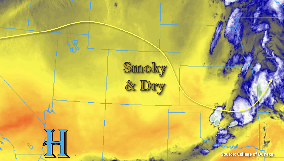
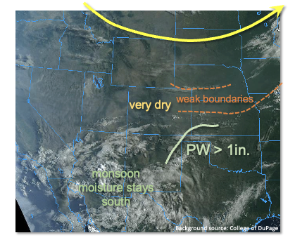
As shown in the visible satellite image, below, Colorado remains stuck between a relatively active monsoon pattern well to the south and a large-scale trough well to the north. In between, very little steering flow implies not much, if any, dynamical support for rainfall. Looking at moisture this morning, it remains well below average with Denver’s PW at 0.55 inches while Grand Junction’s was 0.55 inches. Higher PW, up to 1 inch, was found over a small area along the KS/OK borders. However, it is expected to drop this afternoon as drier air advects in from the north. A couple of weak boundaries marked by wind shifts were noted over the Northeast Plains and Southeast Plains. The northern boundary will be too dry to generate any rainfall. However, the southern boundary is expected to produce isolated to widely scattered thunderstorms over the far southeastern areas this afternoon and evening. Short-term moderate to heavy rainfall is possible, but flooding is not expected with these storms. Isolated showers or a weak storm are also possible over the climatologically favored Sangre de Cristo and San Juan mountains, but will yield little if any rainfall.

In a bit of good news, smoke concentrations, should continue to slowly drop across Colorado today. However, the Urban Corridor and surrounding areas remain under an Air Quality Alert, due to both smoke and ozone, now for over 30 consecutive days.

Today’s Flood Threat Map

For more information on today’s flood threat, see the map below. If there is a threat, hover over the threat areas for more details, and click on burn areas to learn more about them. For Zone-Specific forecasts, scroll below the threat map.

Zone-Specific Forecasts:

San Juan Mountains, San Luis Valley, Southeast Mountains, Southwest Slope, Raton Ridge and Southeast Plains:

Hot with isolated to widely scattered showers and storms possible, with the highest coverage near the OK/KS tri-state border. Max 1-hour rainfall up to 0.9 inches possible in the far southeast areas, along with a chance for damaging wind gusts. Max 1-hour rainfall up to 0.3 inches over the foothills and higher terrain. Flooding is NOT expected today.

Primetime:
4pm to 10pm (far southeast)
12pm to 8pm (foothills & higher terrain)

Grand Valley, Northwest Slope, Central Mountains, Northern Mountains, Palmer Ridge, Front Range, Urban Corridor and Northeast Plains:

Mostly sunny, very hot and dry today with temperatures about 5F above seasonal normal. Patches of smoke will remain over parts of the area, and an Air Quality Alert remains in place along the I-25 corridor from Colorado Springs northward.

FTB 08-10-2021: Poor Air Quality Continues with Isolated Storms Possible Over Eastern Colorado

Issue Date: Tuesday, August 10th, 2021
Issue Time: 9AM MDT

— Flooding is NOT expected today

Shown below is the near surface smoke, which is being advected into the state from the west with the zonal flow pattern. The smoke today is expected to be heaviest over the northern half of the state, and the westerly flow will continue push the thicker plume over the Northern Mountains/Northwest Slope eastward throughout the day. It is likely that the Air Quality Alert will continue.

Also marked in the image below is the 50F dew point line, so moisture return behind a front that passed through overnight was underwhelming. Between PW at Denver and Grand Junction measured at 0.52 inches and 0.57 inches (respectively) and mid-level warming, not expecting much in the way of diurnally driven storms over the mountains this afternoon and evening. A few high-based storms may produce a little precipitation over the San Juan and eastern mountains, but the measurable rainfall will be limited. Besides the mountain storms, a couple storms could form over the climatologically favored Palmer Ridge and along a convergence boundary created by a surface trough to our southeast. A couple of those storms over New Mexico could steer into the far southeast corner of the state. With only light to moderate rainfall anticipated today, flooding is not forecast.

Today’s Flood Threat Map

For more information on today’s flood threat, see the map below. If there is a threat, hover over the threat areas for more details, and click on burn areas to learn more about them. For Zone-Specific forecasts, scroll below the threat map.

Zone-Specific Forecasts:

Northeast Plains, Raton Ridge, Palmer Ridge, Southeast Mountains, San Juan Mountains, Southeast Plains, Front Range & Urban Corridor:

The southern mountains, especially the San Juan Mountains, are closer to the next moisture plume, so they have the best chance for seeing some measurable rainfall over the mountains this afternoon and evening. A stray storm or two may be possible over the southern Front Range. Storm totals should remain under 0.10 inches and brief, but strong outflow winds will be possible. Additional storm development is possible over the southern Raton Ridge and Palmer Ridge. With high cloud bases, only moderate rainfall totals are forecast (up to 0.50 inches), so flooding is NOT expected today. High temperatures will reach into the 90Fs for the lower elevations with 80Fs over the mountains.

Primetime: 1:30PM to 10PM

Grand Valley, San Luis Valley, Northwest Slope, Northern Mountains, Central Mountains & Southwest Slope:

A couple weak showers will be possible along and near the I-70 corridor today. For the most part, storms will produce only virga or a few sprinkles. Stronger storms may also produce some brief, windy conditions as they become outflow driven with the dry surface layer. Elsewhere, it should remain dry and hot. High temperatures are forecast to reach the 90Fs over the lower elevations with upper 90Fs for the Grand Valley. Mountain valleys will reach into the mid to upper 80Fs. Flooding is NOT forecast.

FTB 08-09-2021: Continued Hot And Smoky, With An Isolated Storm Possible Out East

Issue Date: Monday, August 9th, 2021
Issue Time: 9AM MDT

— Flooding is NOT expected today

As shown in the visible satellite image, below, Colorado continues to be positioned in between monsoonal moisture well to the south over AZ and strong shortwave well to our north. Between these features, we will remain under weak anti-cyclonic flow aloft that will generally promote subsidence. A notable surface low pressure was found over the Northern Great Plains today, which will attempt to drag a weak cool front towards Colorado by late afternoon. However, PW remains well below seasonal normal with Grand Junction measuring 0.48 inches and Denver at 0.51 inches. Thus, only an isolated shower or weak storm is expected mainly along the WY and NE borders, especially in the Northeast Plains. The main impact will likely be gusty winds, as rainfall is expected to stay well below flood thresholds.

Regarding the poor air quality, after some abatement in the past 24 hours, another plume of concentrated smoke from the CA wildfires is expected to move in later today. Thus, the entire state remains under an Air Quality Alert. Gradual but slow improvement is expected this week, but major improvement will not occur until the massive, nearly 500,000 acre, Dixie Fire in CA is either contained or put out by Mother Nature.

Today’s Flood Threat Map

For more information on today’s flood threat, see the map below. If there is a threat, hover over the threat areas for more details, and click on burn areas to learn more about them. For Zone-Specific forecasts, scroll below the threat map.

Zone-Specific Forecasts:

Northwest Slope, Central Mountains, Northern Mountains, Palmer Ridge, Front Range, Urban Corridor and Northeast Plains:

Continued hot and mainly dry conditions with an increase in smoke expected this afternoon. An isolated shower or weak storm is possible along the entire WY and NE border. Max 1-hour rainfall up to 0.6 inches in the far eastern Plains and 0.2 inches elsewhere. Damaging winds cannot be ruled out with the eastern Plains storms. Flooding is NOT expected today.

Primetime: 2PM through 9PM

Grand Valley, San Juan Mountains, San Luis Valley, Southeast Mountains, Southwest Slope, Raton Ridge and Southeast Plains:

Continued hot and mainly dry with an increase in smoke this evening. An isolated shower or weak storm cannot be ruled out over the eastern San Juan Mountains this afternoon. However, little if any rainfall is expected.

FTB 08-08-2021: Smoky & Dry Conditions Continue

Issue Date: Sunday, August 8th, 2021
Issue Time: 7:15AM MDT

— Flooding is NOT expected today

Dry air and subsidence have filled in behind the departing trough. With the High to our southwest and westerly flow aloft today, moisture availability will continue to be meager. This is shown by the yellow shades below and PW at Grand Junction being measured at 0.55 inches and 0.54 inches over Denver. Outside of a couple stray and very weak showers possible over the Front Range, all that is forecast today are some fair weather cumulus clouds. Even with the cool start to the morning across the bulk of Colorado, high temperatures today will bump from yesterday and run 5 to 8F above normal. Flooding is NOT forecast.

Despite a little relief from the near surface smoke today for many locations, a second wave of smoke is forecast to arrive to western Colorado by late afternoon into the evening hours. It is likely that the Air Quality Alert will be re-issued for portions of Colorado later this morning, so be sure to stay tuned into your local NWS office for the latest. Also, anticipate the wildfire smoke to hang around over the next few days.

Today’s Flood Threat Map

For more information on today’s flood threat, see the map below. If there is a threat, hover over the threat areas for more details, and click on burn areas to learn more about them. For Zone-Specific forecasts, scroll below the threat map.

Zone-Specific Forecasts:

Northeast Plains, Raton Ridge, Palmer Ridge, Southeast Plains, Southeast Mountains, San Juan Mountains, Front Range & Urban Corridor:

A couple stray, weak showers are possible over the mountains this afternoon and evening, but it’s likely they would only produce some light sprinkles. The increase in afternoon and evening cloud cover over the eastern mountains and adjacent plains will help to cool it off a little bit. High temperatures are forecast in the low to mid-90Fs across the lower elevations with 80Fs for the mountains. Heavier near surface smoke is forecast over the Southeast Plains with clearing of the near surface smoke elsewhere. Flooding is NOT forecast.

Grand Valley, Southeast Mountains, San Juan Mountains, San Luis Valley, Northwest Slope, Northern Mountains, Central Mountains & Southwest Slope:

Gradual clearing of the near surface smoke is forecast by this afternoon except over the southwest corner of the state and likely the San Luis Valley. This will be short-lived as another smoke plume arrives this evening. As far as rainfall, only expecting some fair weather cumulus this afternoon over portions of the southern mountains with clear conditions elsewhere. Flooding is NOT forecast. High temperatures are forecast to reach the mid-90Fs for the lower elevation valleys and 80Fs for the mountain valleys.