Issue Date: Monday, August 9th, 2021
Issue Time: 9AM MDT
— Flooding is NOT expected today
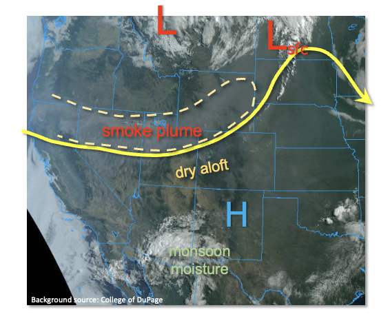
As shown in the visible satellite image, below, Colorado continues to be positioned in between monsoonal moisture well to the south over AZ and strong shortwave well to our north. Between these features, we will remain under weak anti-cyclonic flow aloft that will generally promote subsidence. A notable surface low pressure was found over the Northern Great Plains today, which will attempt to drag a weak cool front towards Colorado by late afternoon. However, PW remains well below seasonal normal with Grand Junction measuring 0.48 inches and Denver at 0.51 inches. Thus, only an isolated shower or weak storm is expected mainly along the WY and NE borders, especially in the Northeast Plains. The main impact will likely be gusty winds, as rainfall is expected to stay well below flood thresholds.
Regarding the poor air quality, after some abatement in the past 24 hours, another plume of concentrated smoke from the CA wildfires is expected to move in later today. Thus, the entire state remains under an Air Quality Alert. Gradual but slow improvement is expected this week, but major improvement will not occur until the massive, nearly 500,000 acre, Dixie Fire in CA is either contained or put out by Mother Nature.
Today’s Flood Threat Map
For more information on today’s flood threat, see the map below. If there is a threat, hover over the threat areas for more details, and click on burn areas to learn more about them. For Zone-Specific forecasts, scroll below the threat map.

Zone-Specific Forecasts:
Northwest Slope, Central Mountains, Northern Mountains, Palmer Ridge, Front Range, Urban Corridor and Northeast Plains:
Continued hot and mainly dry conditions with an increase in smoke expected this afternoon. An isolated shower or weak storm is possible along the entire WY and NE border. Max 1-hour rainfall up to 0.6 inches in the far eastern Plains and 0.2 inches elsewhere. Damaging winds cannot be ruled out with the eastern Plains storms. Flooding is NOT expected today.
Primetime: 2PM through 9PM
Grand Valley, San Juan Mountains, San Luis Valley, Southeast Mountains, Southwest Slope, Raton Ridge and Southeast Plains:
Continued hot and mainly dry with an increase in smoke this evening. An isolated shower or weak storm cannot be ruled out over the eastern San Juan Mountains this afternoon. However, little if any rainfall is expected.