Issue Date: Sunday, August 15th, 2021
Issue Time: 9:20AM MDT
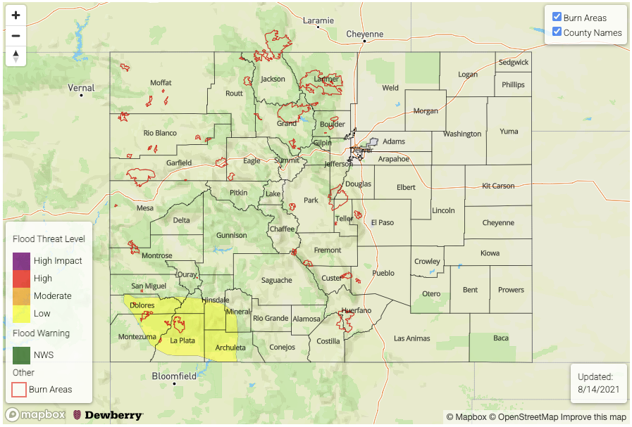
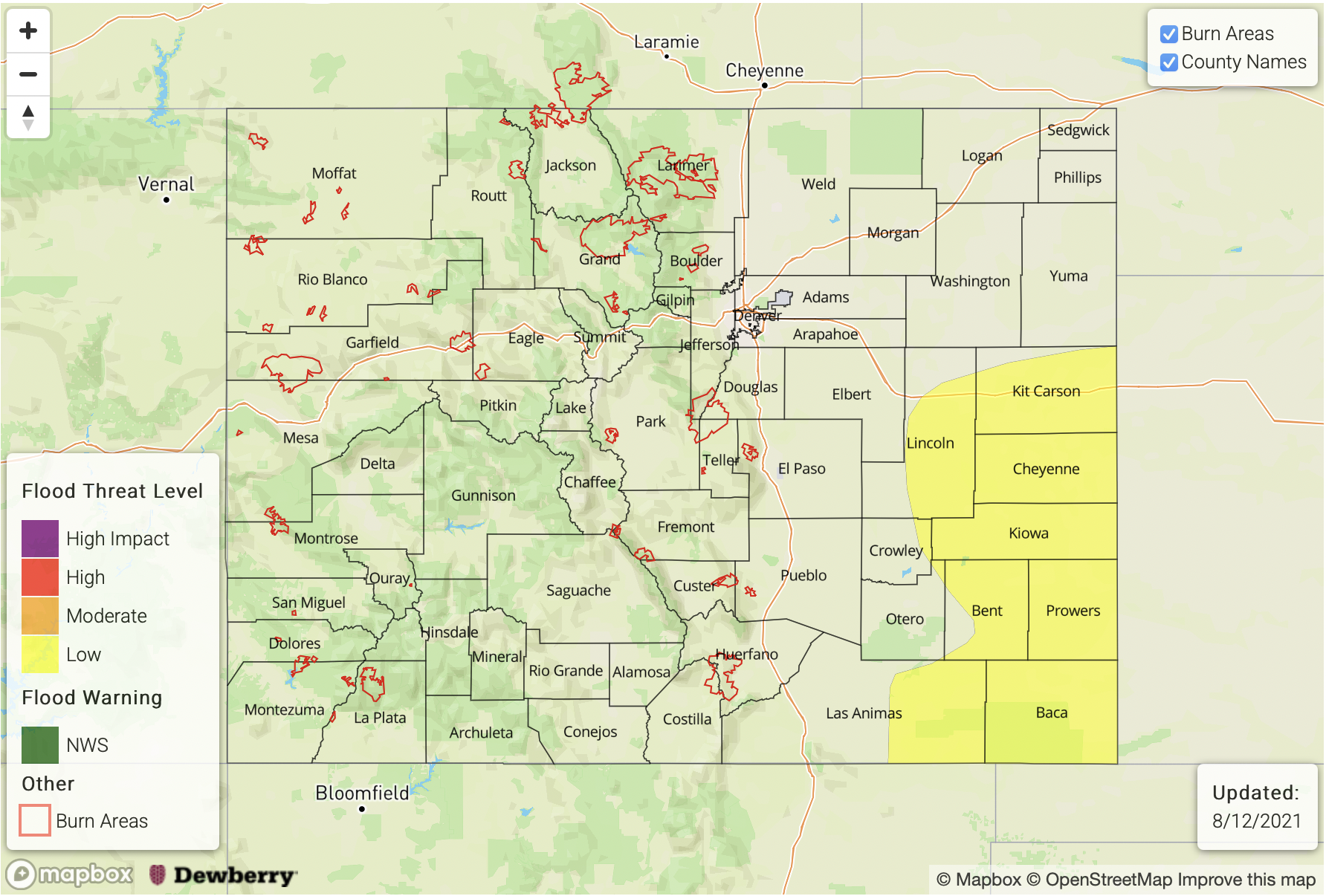
— A LOW flood threat has been posted for parts of the San Juan Mountains, Central Mountains and Southeast Mountains
It is quite unusual for any part of Colorado to wake up to thunderstorm activity especially this late in the summer, but such is the case this Sunday morning. A narrow line of elevated convection is fueling some very short pulses of heavy rainfall over the Northeast Plains. This is a good indication that today’s atmosphere is ready to generate rainfall, although the vast majority of it will fortunately not pose a flood threat.
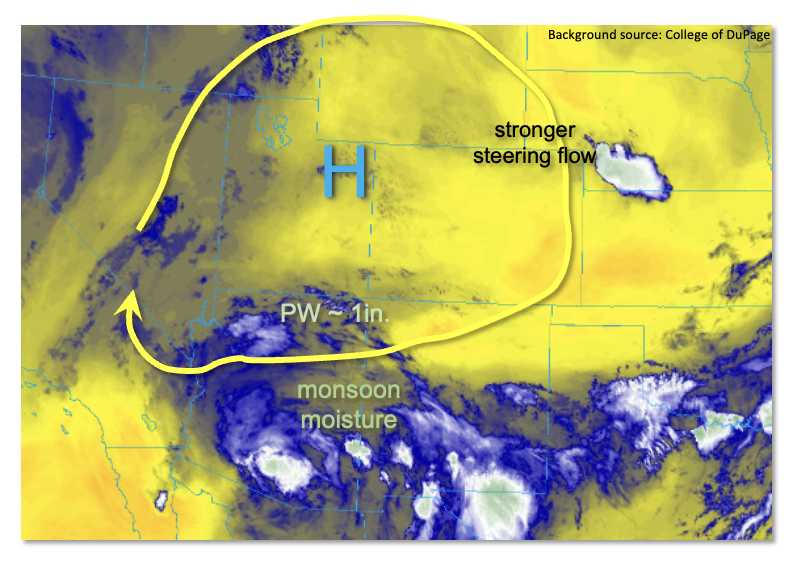
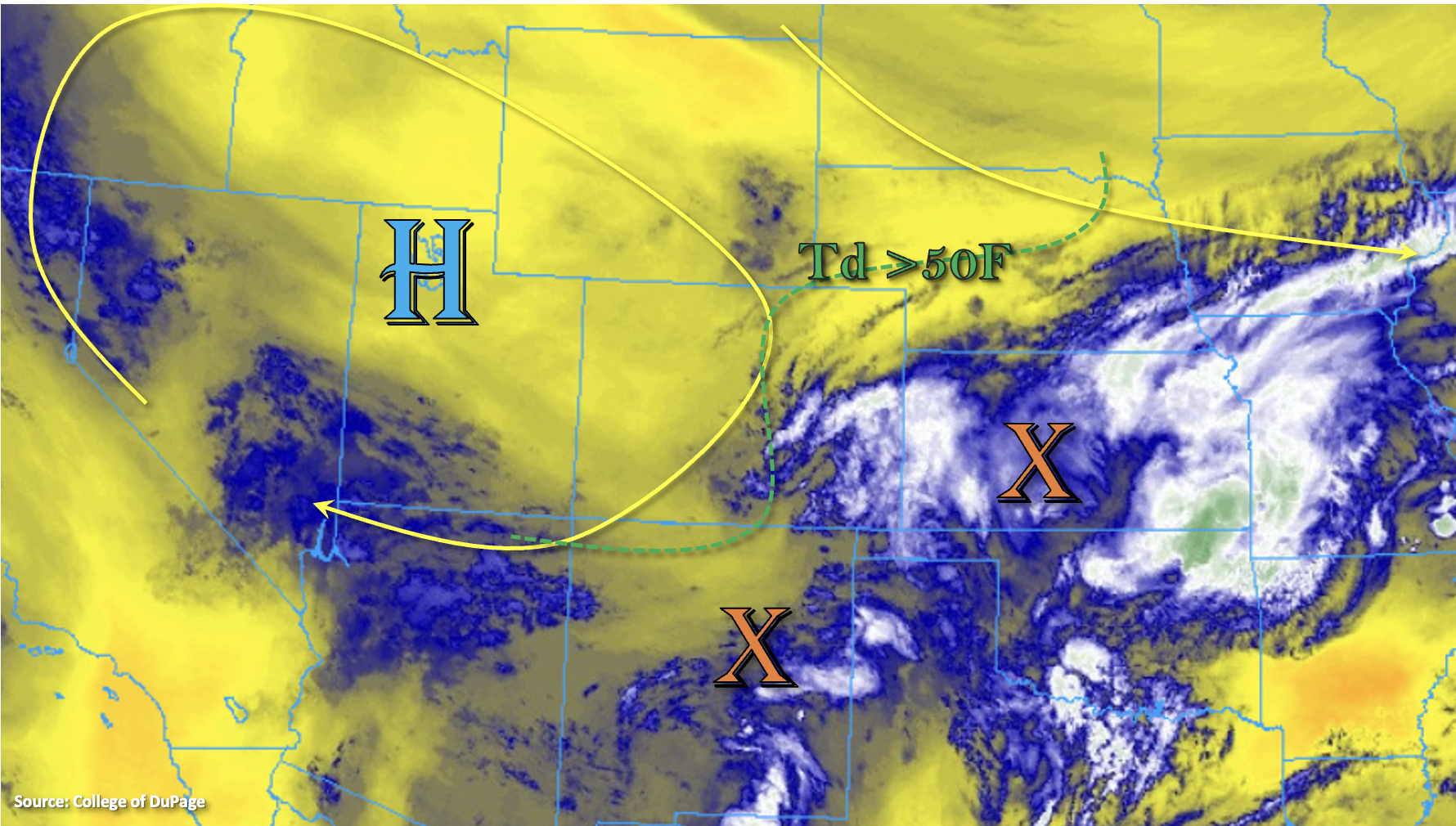
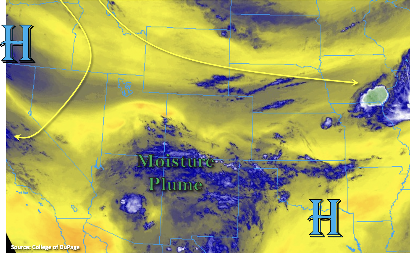
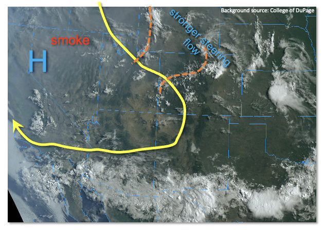
Looking at the visible satellite image, below, we continue to see a very messy picture over Colorado. Our state lies on the eastern periphery of a seasonably strong upper-level ridge that is centered over CA. With a fairly strong pressure gradient between the ridge and a trough over the Central Plains, southeasterly steering winds continue to remain strong, above 25mph for most of Colorado. This will limit point rainfall for most areas. Switching to the moisture analysis, Denver’s Precipitable Water (PW) is 0.79 inches, up slightly from yesterday. On the other side of the Continental Divide, Grand Junction’s PW has also increased a bit to 0.8 inches. However, at both soundings, moisture was “top-heavy”, which is not a good sign for heavy rainfall potential. Further south, however, the moisture profile looks better, with PW up to 0.9 inches along the NM border and higher near-surface moisture. Mid-level temperatures are colder today than yesterday and there is more substantial synoptic scale lift today, both of which will result in an uptick in rainfall coverage. The key to the heavy rainfall potential will be to find the juxtaposition of instability and relatively slow steering flow, with the southern high terrain appearing to meet both criteria.
Translating everything into sensible weather, we expect scattered to numerous showers and thunderstorms over basically the entire Continental Divide spine of higher terrain. Over northern and central areas, only very short-term heavy rainfall is expected. Further south, over the San Juans and Southeast Mountains, 60-90 minutes of heavy rainfall will be possible, which warrants a LOW flood threat for isolated flash flooding, debris slides and mud flows.
Isolated severe storms are expected in the foothills and plains east of the Continental Divide. The main impact looks to be damaging wind gusts over 60mph, though hail up to 1.25 inches is also possible.
Today’s Flood Threat Map
For more information on today’s flood threat, see the map below. If there is a threat, hover over the threat areas for more details, and click on burn areas to learn more about them. For Zone-Specific forecasts, scroll below the threat map.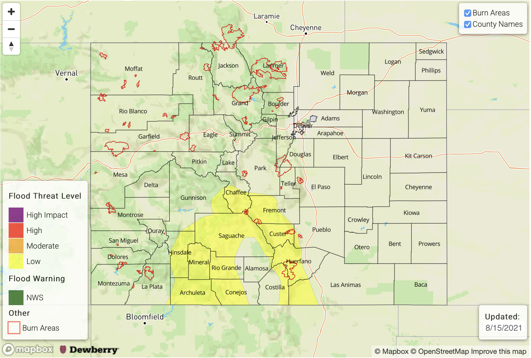
Zone-Specific Forecasts:
Central Mountains, San Juan Mountains, Southwest Slope, San Luis Valley and Southeast Mountains:
Numerous showers and thunderstorms likely this afternoon and evening with max 30-minute rainfall up to 0.8 inches and max 1-hour rainfall up to 1.2 inches. The highest coverage will be at elevations above 7,500 feet. A LOW flood threat has been posted for isolated flash flooding, mud flows and debris slides especially over steeper terrain. A few storms with gusty winds will be possible late into the evening.
Primetime:
1PM through 10PM
Southeast Plains and Northeast Plains:
Isolated to widely scattered thunderstorms this afternoon with ax 1-hour rainfall up to 1.5 inches possible. Some nuisance field and road ponding is possible today but flooding is NOT expected today. Damaging winds and large hail up to 1.25 inches will be possible with the stronger storms today.
Primetime: 12PM through 10PM
Grand Valley, Northwest Slope, Central Mountains, Northern Mountains, Palmer Ridge, Front Range, Urban Corridor and Raton Ridge:
Scattered showers and thunderstorms expected this afternoon and evening, mainly over the higher terrain above 7,500 feet but a few storms will make it into the foothills and plains east of the Continental Divide. Max 30-minute rainfall up to 0.6 inches, with max 1-hour rainfall up to 0.9 inches. Gusty winds will be possible with the stronger storms especially later this afternoon.
Primetime: 12PM through 11PM