Issue Date: Friday, August 13th, 2021
Issue Time: 10:20AM MDT
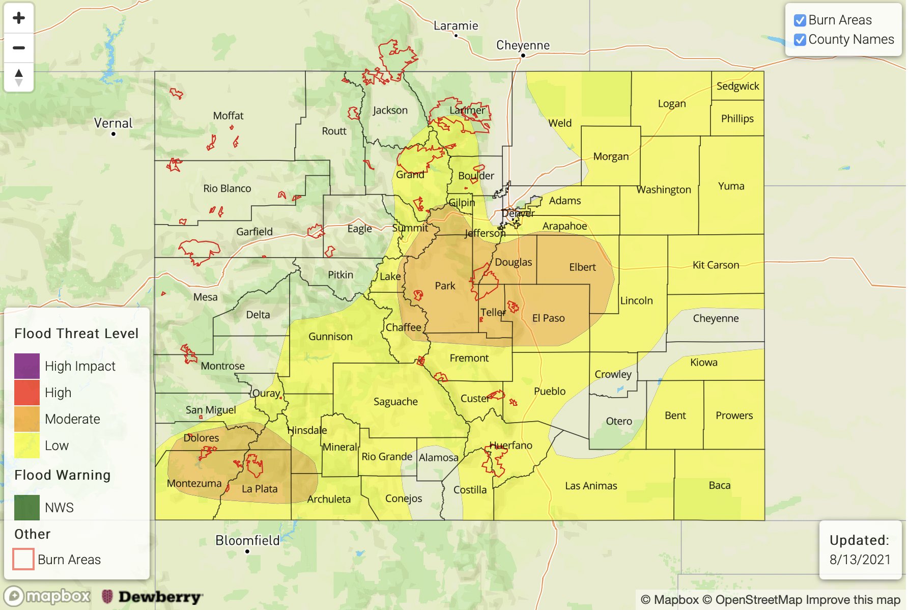
— A MODERATE flood threat has been issued for the Southwest Slope, San Juan Mountains, Central Mountains, Front Range, Urban Corridor and Palmer Ridge
— A LOW flood threat has been issued for the Southeast Mountains, Northern Mountains, Northeast Plains, Raton Ridge and Southeast Plains
Today the 500mb High will continue to strengthen, and the majority of the state will be under the influence of the clockwise flow. Over the far southeast corner of the state, there’s still some westerly flow with yesterday’s front draped over the central eastern plains. Monsoon moisture has started to fill in statewide as shown by dew points > 50F over eastern Colorado and at a few stations over the southwest corner. PW has risen to 0.60 inches over Grand Junction and 0.92 inches at Denver. Dew points should remain high throughout the day as the surface flow will be favorable for moisture advection in a post-frontal, upslope flow environment. With slow steering flows under the building ridge and some mid-level energy in the area, widespread, heavy rainfall producing storms are forecast today. Additionally, a couple severe thunderstorms will be possible over the eastern plains.
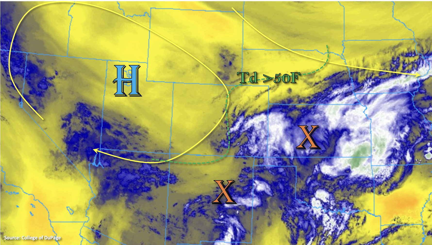
Storms over the mountains will pop by early afternoon and are forecast to be widespread in nature. It is likely that outflow boundaries will help to produce additional storm coverage in the moisture-rich environment. A couple stronger thunderstorms possible with the main threats being hail and brief outflow winds. Best chance for these storms will be over the Southwest Slope high terrains and southern Front Range. A MODERATE flood threat has been issued for these areas due to a higher likelihood for stronger and training storms producing heavy rainfall.
Rainfall might not be as easy to come by over the adjacent plains today as Denver’s sounding this morning showed a decent cap, which could inhibit convection this afternoon. Morning model guidance has also quieted over the far eastern plains. Should an outflow boundary from a storm to the north or enhanced convergence from a developing Denver Cyclone be able to trigger convection with the eroding cap, a couple severe thunderstorms may be possible over this forecast region later this afternoon and evening. This would also hold true for any storms that track into the state off the Cheyenne Ridge. On top of severe weather, these storms will also be capable of producing very heavy downpours, so a LOW flood threat has been issued.
Finally, further south over the far Southeast Plains, it is possible that a convergence boundary may move northward from New Mexico and Oklahoma late this afternoon. It may be able to help break the cap over the area, if it does so, a couple severe thunderstorms may be possible. In addition to hail and strong outflow winds, heavy rainfall would be likely due to dew points in the low to mid-60s. Less confidence that the boundary will make it northward into the state, so only a LOW flood threat has been issued.
Today’s Flood Threat Map
For more information on today’s flood threat, see the map below. If there is a threat, hover over the threat areas for more details, and click on burn areas to learn more about them. For Zone-Specific forecasts, scroll below the threat map.
Zone-Specific Forecasts:
Central Mountains, Southeast Mountains, Urban Corridor, San Luis Valley, & Front Range:
More copious storms are is forecast today with some mid-level energy and a post-frontal upslope flow environment. In addition to heavy rainfall, storms may produce some small hail and strong outflow winds. Max 1-hour rain rates up to 1.75 inches and storm totals up to 2.75 inches will be possible if multiple storms track over the same area. Flood threats include mud flows and debris slides along with road flooding and local stream flooding. A MODERATE/LOW flood threat have been issued.
Primetime: 1PM to 10PM
Grand Valley, San Juan Mountains, Northwest Slope, Northern Mountains, & Southwest Slope:
It should stay more dry north and across the western border (north), but some healthy moisture has moved into the Southwest corner of the state. This will help produce numerous storms over the Southwest Slope and San Juan Mountains this afternoon. Max 1-hour rain rates up to 1.75 inches will be possible and a couple rounds of storms could bump totals near 3 inches. A MODERATE flood threat has been issued for road flooding, mud flows/debris slides and local stream/creek flooding. Stronger thunderstorms could produce hail and brief outflow winds as well.
Primetime: 1PM to 11PM
Northeast Plains, Raton Ridge, Palmer Ridge & Southeast Plains:
There’s a chance for some severe thunderstorms to develop late this afternoon/evening out east both north and south. This would only occur if storms can break through the cap. Max 1-hour rain rates up to 2.50 inches with storm totals up to 3.50 inches would be possible. Further north, there’s a bit more low-level wind shear, so a brief, weak tornado may be possible. The main threats from the severe storms would be large hail and strong outflow winds. Additional storms could develop over the plains from other outflow boundaries, so a large area of a LOW flood threat has been issued. Flood threats for storms that can develop include road flooding, field ponding and local stream flash flooding.
Primetime: 3:30PM to Midnight