Issue Date: Saturday, August 14th, 2021
Issue Time: 9:25AM MDT
— A LOW flood threat has been posted for parts of the San Juan Mountains
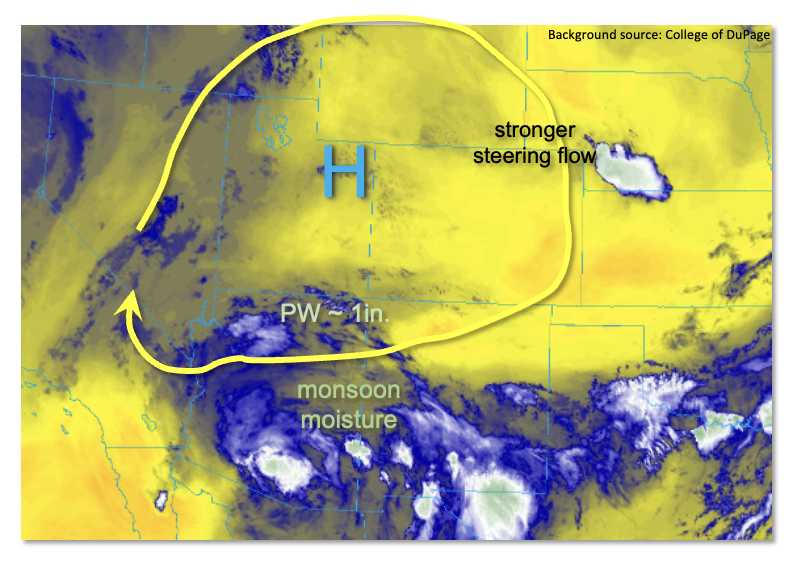
Colorado awoke to mainly clear skies this morning. However, as shown in the water vapor image, below, the atmosphere today remains in a rather confused state with pockets of higher moisture intertwined with drier air. Precipitable Water (PW) at Denver this morning was 0.74 inches, down from yesterday’s 0.92 inches. However, PW at North Platte (NE) and Dodge City (KS) were over 1.30 inches, signifying a strong moisture gradient over eastern Colorado. Grand Junction’s morning PW was 0.67 inches, up slightly from yesterday, but with a moisture profile not conducive for much, if any, rainfall. The PW in Albuquerque was an impressive 1.15 inches, and up to 1 inch of PW is estimated over far southwest Colorado. This appears to be the area to watch for flooding potential today.
In the mid-levels, a strengthening upper-level ridge, currently centered over Utah will support a generally clockwise flow of air around its eastern fringe. Little to no forcing features are easily discernable, making for a challenging forecast. An ongoing storm complex over western Nebraska was being fueled by elevated convection and is expected to dissipate later this morning. However, it could send an outflow boundary south along the KS border and spark an isolated to widely scattered severe storm. Flooding looks unlikely with this situation as steering winds will be strengthening through the day and exceed 25 mph by afternoon. With adequate instability and strong wind shear, however, large hail and damaging winds will be possible with any storms that form.
Over most of the higher terrain, moisture is not overly impressive this morning, but scattered showers and thunderstorms are still expected this afternoon. The vast majority of the activity should be benign with only short-term moderate intensity rainfall possible. Over the San Juans, however, a bit more moisture with slower steering flow does support storms capable of 30-60 minute duration heavy rainfall. A LOW flood threat has been posted for this limited area for today.
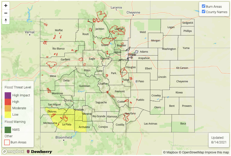
Today’s Flood Threat Map
For more information on today’s flood threat, see the map below. If there is a threat, hover over the threat areas for more details, and click on burn areas to learn more about them. For Zone-Specific forecasts, scroll below the threat map.
Zone-Specific Forecasts:
San Juan Mountains and Southwest Slope:
Scattered showers and thunderstorms likely this afternoon and evening with max 30-minute rainfall up to 0.7 inches and max 1-hour rainfall up to 1.1 inches. A LOW flood threat has been posted for isolated flash flooding, mud flows and debris slides especially over steeper terrain. A few storms with gusty winds will be possible late into the evening.
Primetime:
1PM through 10PM
Southeast Plains and Northeast Plains:
Hot and mainly dry today though isolated to widely scattered thunderstorms are possible mainly along the KS border this afternoon and evening. Max 1-hour rainfall up to 1.5 inches possible, which could cause some nuisance field and road ponding. However, flooding is NOT expected today. Severe weather wise, large hail and damaging winds will be possible with the stronger storms.
Primetime: 2PM through 10PM
Southeast Mountains, Raton Ridge, San Luis Valley, Grand Valley, Northwest Slope, Central Mountains, Northern Mountains, Palmer Ridge, Front Range and Urban Corridor:
Scattered showers and thunderstorms expected this afternoon and evening, mainly over the higher terrain above 8,000 feet. Max 30-minute rainfall up to 0.5 inches, with max 1-hour rainfall up to 0.8 inches. Gusty winds will be possible with the stronger storms especially later this afternoon. A few storms could make it eastward off the higher terrain by late evening, but only short-term moderate intensity rainfall is expected, along with possibly gusty winds.
Primetime: 12PM through 11PM