Issue Date: Thursday, August 12th, 2021
Issue Time: 9:50AM MDT
— A LOW flood threat has been issued for the Southeast Plains, Palmer Ridge, Raton Ridge and Northeast Plains
— Possible PM update may be issued
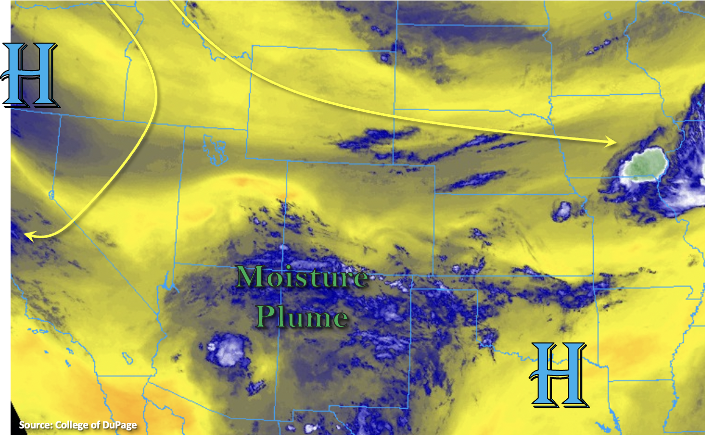
The departing trough to our north will allow a ridge to begin to build today, which will pull the moisture plume, that was sitting to our south over the last few days, northward. There is already a sharp increase in moisture across the southern border as shown in the water vapor imagery below. While PW at Grand Junction was measured only at 0.33 inches, just to our south over Albuquerque, PW was over 1 inch. PW has also begun to rise over Denver with a morning measurement of 0.63 inches with PW over an inch at Amarillo and Dodge City. So, it’s a strong moisture gradient. This will translate to an uptick in rainfall today, particularly over the southern mountains and Southeast Plains.
Initially, the dry surface layer will cause storms that develop over the mountains to produce less efficient rain rates and promote strong outflow winds. Furthermore, an increase in some mid-level energy will allow storms to be more widespread than just the typical diurnally driven thunderstorms that we’ve seen the last couple of days. Over the plains, slightly better surface moisture will translate into some higher rain rates. Enhanced convergence along a couple boundaries and some mid-level energy from the south will be the main forcing mechanisms for storms. While the severe threat will be limited with the pulse-like storms, some hail and strong outflow winds could still occur. Very slow steering flows and enhanced convergence may allow for some local heavy downpours within the high moisture environment, so a LOW flood threat has been issued.
Finally, an axis of instability may help generate some storms over the foothills, Urban Corridor, and perhaps the Northeast Plains overnight. Unsure about the amount of moisture that will develop over the area behind the front, and if the lift will be enough to overcome the cap. For now, we’ll go with no flood threat for this region and issue a PM update if the threat for heavy rainfall increases.
Today’s Flood Threat Map
For more information on today’s flood threat, see the map below. If there is a threat, hover over the threat areas for more details, and click on burn areas to learn more about them. For Zone-Specific forecasts, scroll below the threat map.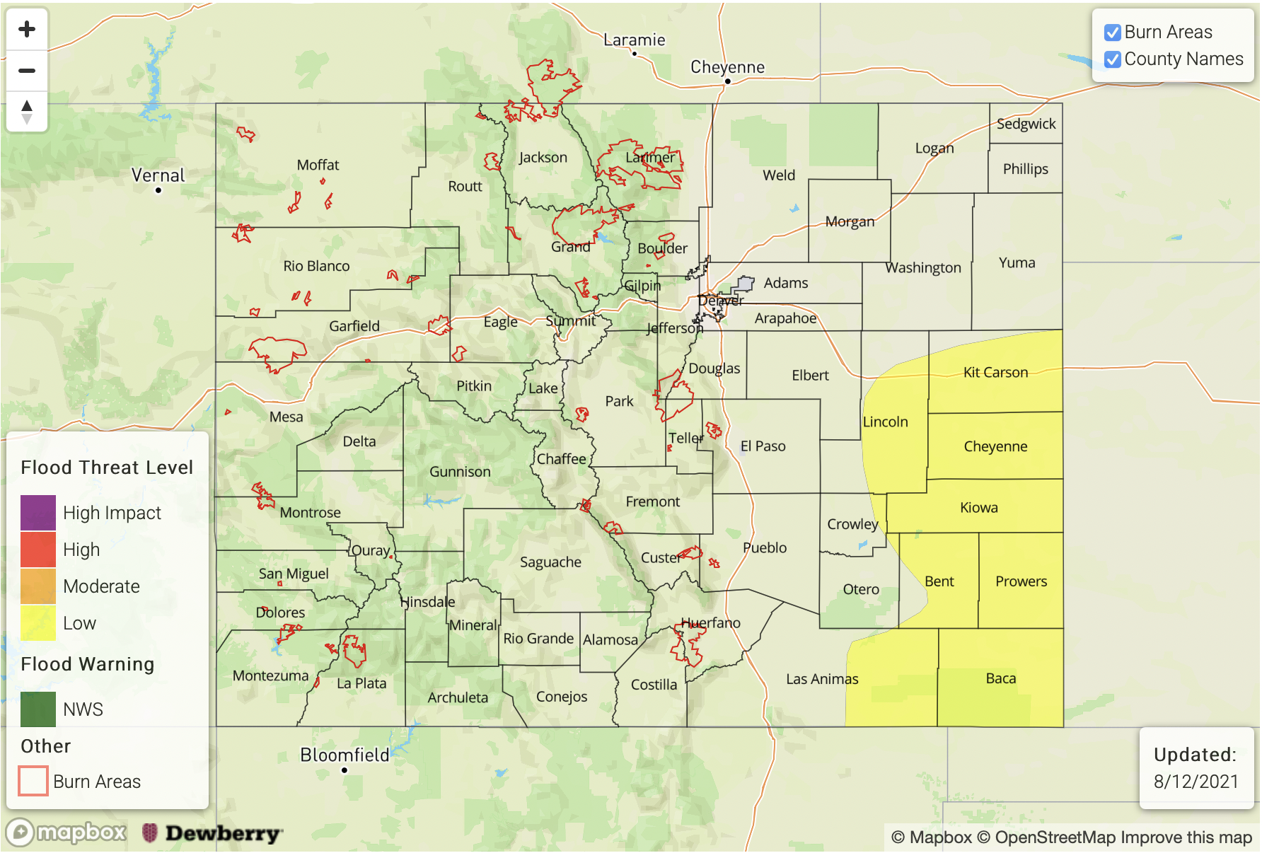
Zone-Specific Forecasts:
Northeast Plains, Raton Ridge, Palmer Ridge & Southeast Plains:
Best chance for heavy rainfall this afternoon will be over the Palmer Ridge and Southeast Plains. Enhanced convergence along boundaries, lee troughing and mid-level energy could help anchor storms and promote some heavy downpours. Max 1-hour rain rates up to 1.90 inches will be possible with isolated storm totals up to 2.75 inches. Field ponding, arroyo flooding and road flooding will be the main threats from the stronger storms that can develop. A LOW flood threat has been issued. Additional overnight storms may be possible over the Northeast Plains along an axis of instability that develops behind the front. If storms can break the cap with some lift, max 1-hour rain rates up to 1.75 inches will be possible.
Primetime: 1PM to 3:30AM
Central Mountains, Southeast Mountains, San Juan Mountains, San Luis Valley, Front Range & Urban Corridor:
Storms should pick up in coverage over the mountains this afternoon and evening. Further north storms will be located along and near the Continental Divide, and further south, storms should have more widespread coverage. Isolated max 1-hour rain rates up to 0.50 inches will be possible, but most storms will produce lower accumulations and more brief windy conditions and dangerous lightning. Flooding is NOT anticipated from these storms.
Overnight, some additional rainfall over the Front Range and Urban Corridor could be possible. For this to occur, first, moisture will have to increase, and second, lift will have to be sufficient to break the cap. If both of these occur, heavy rainfall would be possible with the storms that develop. However, low confidence in this outcome, so going with no flood threat for now. If the overnight, heavy rainfall threat increases, a PM update will be issued.
Primetime: 1PM to 3:30AM
Grand Valley, Northwest Slope, Northern Mountains, & Southwest Slope:
Storms should be confined to the mountains this afternoon, though an increase in cloud cover will likely occur over the Southwest Slope. Hot temperatures return, especially over the Grand Valley and near surface smoke will continue to promote poor air quality.