Issue Date: Thursday, August 19th, 2021
Issue Time: 10:40AM MDT
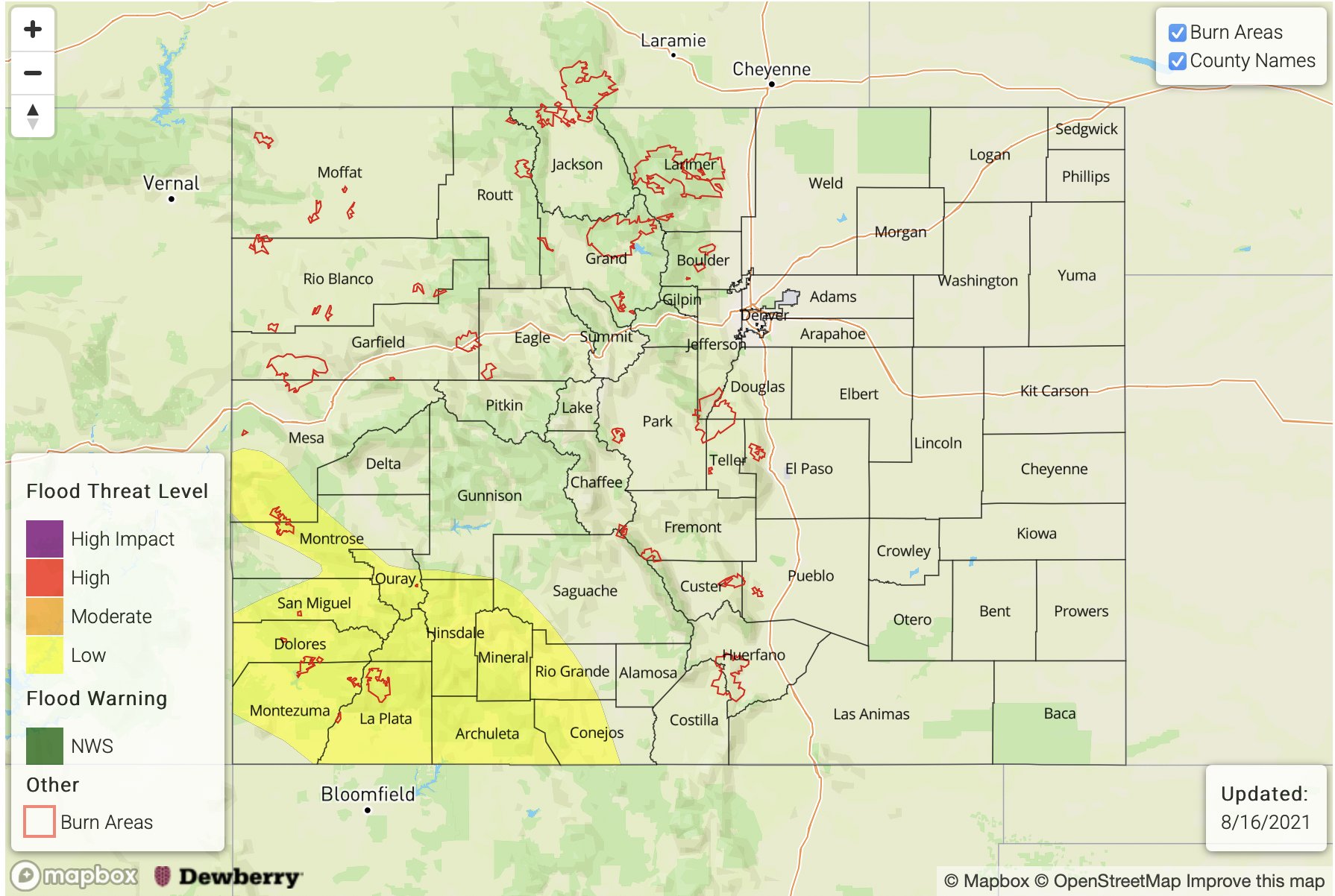
— A HIGH flood threat has been issued for the Grand Valley, Southwest Slope & Northeast Plains
— A MODERATE flood threat has been issued for the Northwest Slope
— A LOW flood threat has been issued for the San Juan Mountains, Central Mountains, Northern Mountains, Front Range, Urban Corridor and Southeast Plains
PM Update: Very heavy and widespread rainfall is becoming increasingly likely over the far Northeast Plains this evening/overnight due to strong moisture convergence in the area and training storms aided by the jet. A HIGH flood threat has now been issued for Sedgwick, Phillips and Yuma Counties, and the MODERATE flood threat has been shifted slightly further south. Max 3-hour rain rates up to 5 inches will be possible and local accumulations could slightly exceed that amount by morning. These totals have the potential to cause local creek/stream flooding, heavy field ponding and severe road flooding. Please stay tuned to your local NWS office for the latest on real-time warnings that are issued.
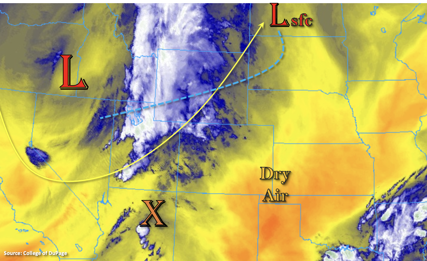
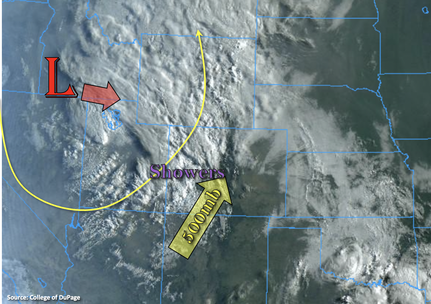
It’s a busy weather day ahead for most of the state, so we’ll just go ahead and jump right into the discussion. Over western Colorado, above average moisture (PW just over an inch) is already combining with upper-level lift from the jet, which is producing moderate showers this morning. Snow was being reported at Wolf Creek Pass, so it’s possible that there is a dusting of snow on some of the high peaks. This first round of rainfall is forecast to continue to move northeast throughout the morning before the next set of storms to arrives with the cold front early this afternoon. Within this second wave of storms, rain rates should pick up in intensity and coverage, and a good soaking is anticipated for most of the region. A couple severe storms might be possible south where there is a better chance for a break in cloud cover, which would allow some instability to build. Moderate rainfall accumulations over a longer duration should lead way to an increase in runoff as soils become saturated, which could cause local streams and creeks to run at bankfull or minor flooding conditions. There is also an uptick in the risk for mud flows and debris slides with embedded convection as the soils become more unstable. A HIGH/MODERATE flood threat has been issued for this area, and the flood threat is over a longer duration rather than the typical 1 to 2 hour threat. Storms are expected continue into the overnight hours, but should decrease in intensity by the early morning hours.
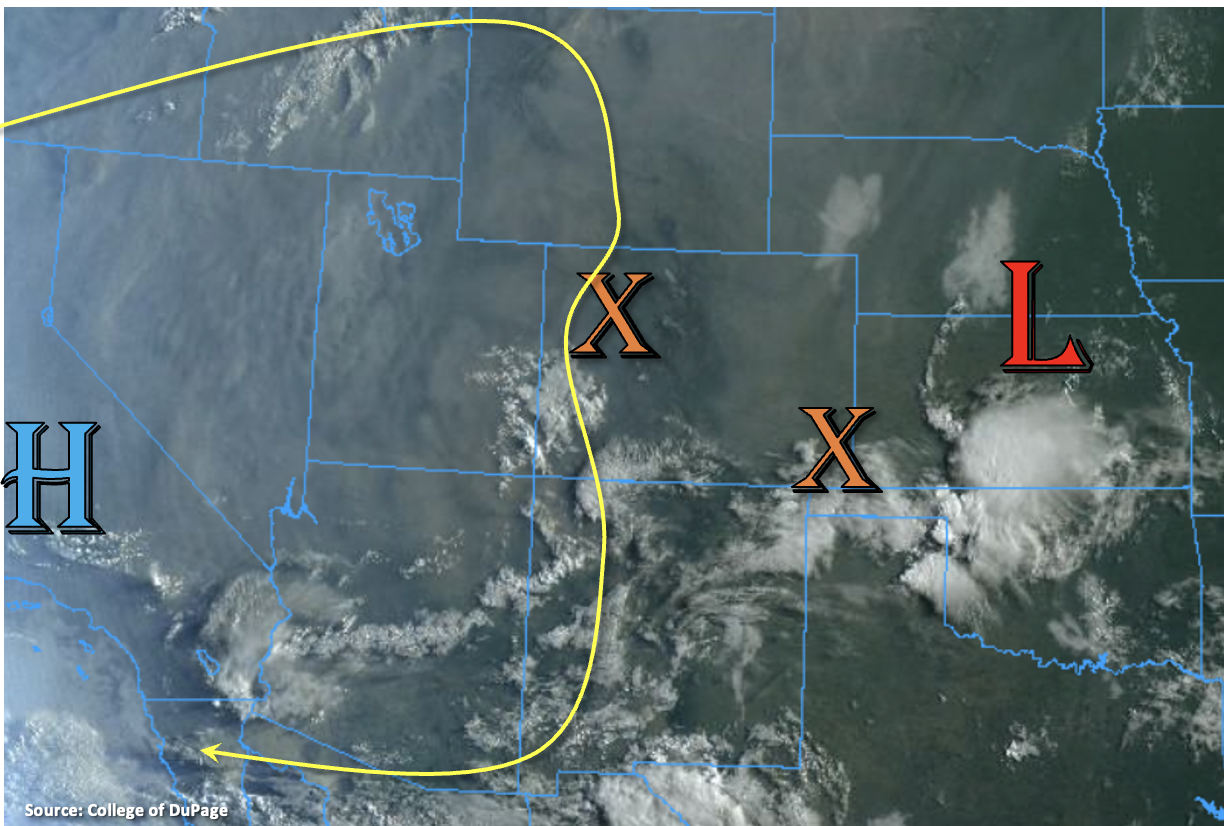
As the closed Low system, marked below, slowly meanders southeast throughout the day, the area of lift currently over western Colorado will move east with it. This mid-level energy arriving at peak heating, diffluent flow aloft and a convergence boundary should help to spark some showers and thunderstorms over the Front Range and adjacent Urban Corridor this afternoon and evening. Additional severe thunderstorms may be possible over the Northeast Plains later this afternoon and overnight, which would be capable of producing strong outflow winds, large hail and a possible tornado or two. Throughout the day, surface moisture is expected to be reinforced over the area with southeasterly winds on the east side of the surface Low, which combined with the increased dynamics in the area will make storms capable of producing very heavy rainfall. Thus, a MODERATE/LOW flood threat has been issued. Drier air on the south and east side of the surface Low along with downsloping winds should limit the chances for precipitation over the southern half of eastern Colorado.
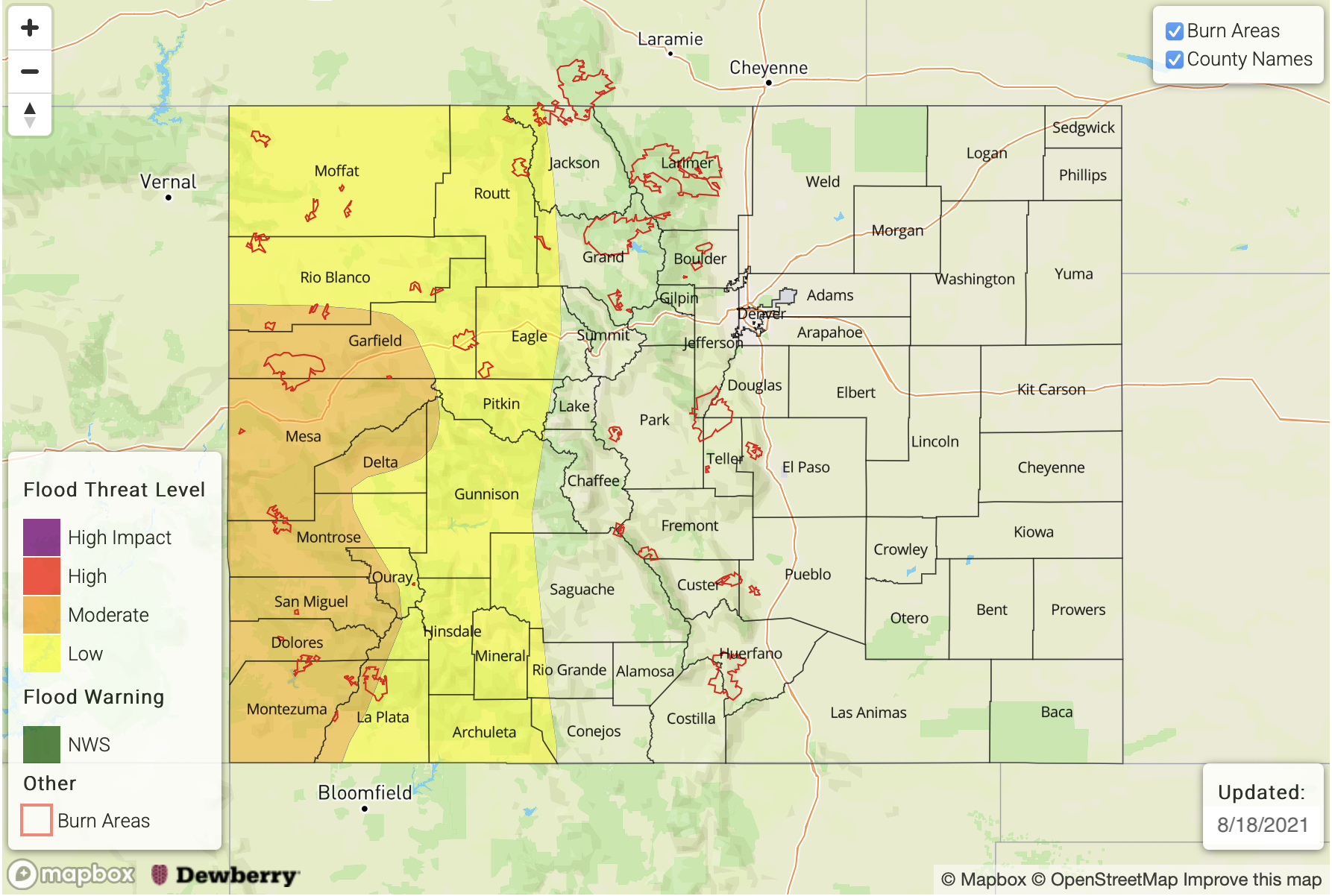
Today’s Flood Threat Map
For more information on today’s flood threat, see the map below. If there is a threat, hover over the threat areas for more details, and click on burn areas to learn more about them. For Zone-Specific forecasts, scroll below the threat map.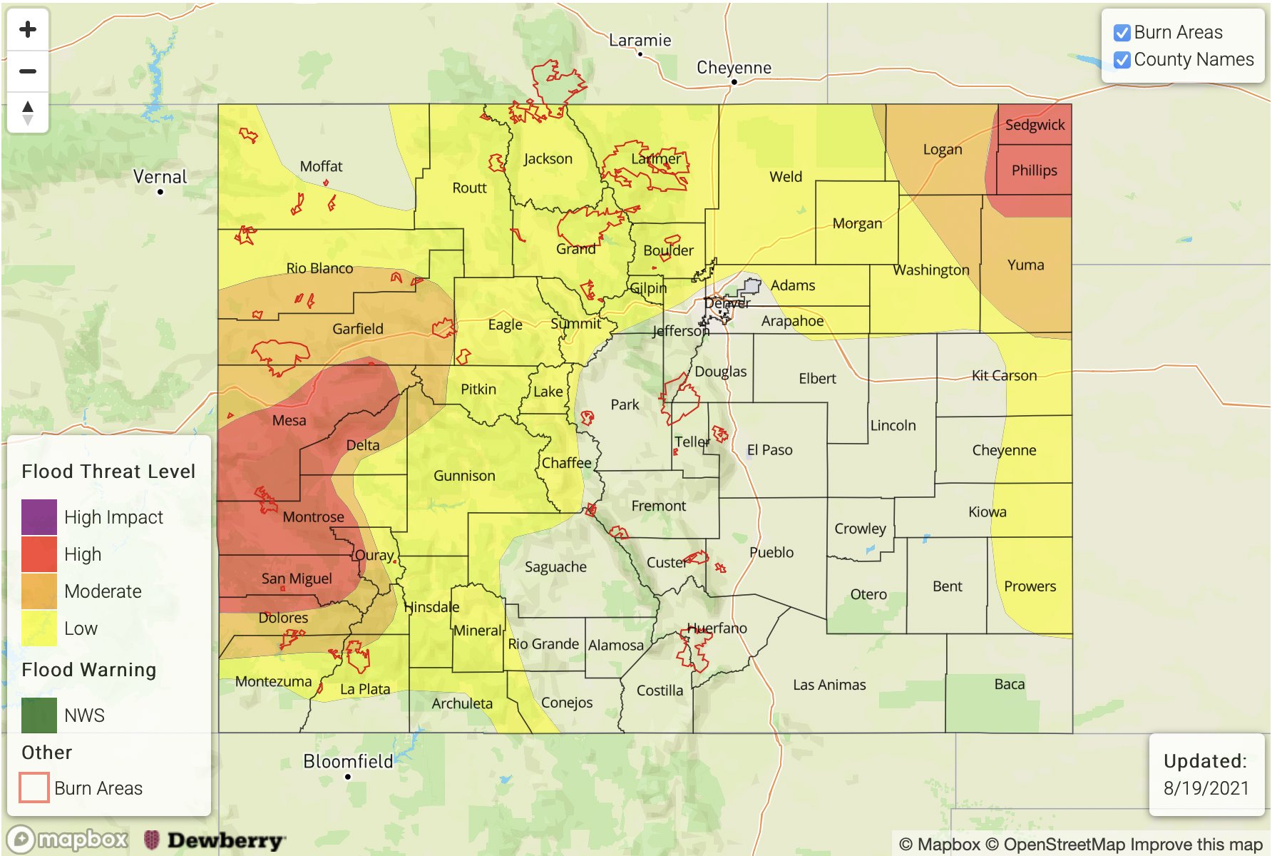
Zone-Specific Forecasts:
Grand Valley, Central Mountains, San Juan Mountains, Northwest Slope, Northern Mountains, & Southwest Slope:
Another round of more vigorous storms is on its way this afternoon. Max 1-hour rain rates up to 1 inch with storm totals up 3.50 in the HIGH threat area are possible. This longer duration threat with more widespread rainfall could cause excessive runoff and flooding of local streams, creeks and roads. There is also an increased threat for mud flows and debris slides with embedded convection over saturated soils. Thus, a HIGH flood threat has been issued. Storms will likely continue over the mountains into the overnight hours with the heavier rainfall ending around midnight. Moderate and lighter rainfall should end around 4AM. Stay tuned to your local NWS office for the latest on real-time warnings that will likely be issued today.
Primetime: Ongoing to 4AM
Front Range, Northeast Plains, Urban Corridor & Southeast Plains:
Increasing chance for rainfall across the northern portion of eastern Colorado today. Max 1-hour rain rates up to 1.25 inches (west) and 2 inches (east) will be possible. Severe thunderstorms will also be possible over the Northeast Plains with the main threats being very large hail, strong outflow winds and perhaps a tornado or two this afternoon and overnight. On top of these threats, very heavy rainfall could accompany the storms with isolated totals up 4.50 inches possible. The potential for this very heavy rainfall is most likely along the border. A MODERATE threat has been issued for this reason with the main threats being road flooding, heavy field ponding and flooding of local streams/creeks. There is an outside heavy rainfall across the far Southeast Plains if the moisture doesn’t scour out too far east on the southeast side of the surface Low. If storms can pop or back-build into the area, max 1-hour rain rates up to 1.75 inches will be possible. A LOW flood threat has been extended south for this reason. Storms will likely continue into the overnight hours making this an overnight flood threat, and some showers are possible over the Urban Corridor tomorrow morning.
Primetime: 12PM to 10PM (west); 3PM to 4AM (east)
Southeast Mountains, San Luis Valley, Raton Ridge & Palmer Ridge:
Downsloping winds and lower moisture over these regions from the surface Low should keep the areas mostly rain-free today. There is still a chance for a couple showers to develop over the Southeast Mountains where rain rates up to 0.15 inches will be possible. As anticipated, flooding is NOT forecast.